Highlights:
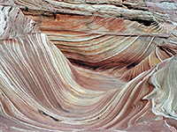
Thin-layered, multicolored sandstone eroded into hoodoos, tepees, ravines, arches and countless other strange forms, spread out over an eight mile section of sandy terrain spanning the Utah/Arizona border. Divided into North and South regions. By far the most famous location (in the north) is The Wave, a smooth, stripy gully between a group of conical mounds
Nearby town:
Page, 45 miles
Management:
BLM; part of Paria Canyon-Vermilion Cliffs Wilderness, and Vermilion Cliffs National Monument. Visitation is managed via a permit system
Location:
36.995, -112.006 (The Wave)
Seasons:
All year
Rating (1-5):
★★★★★

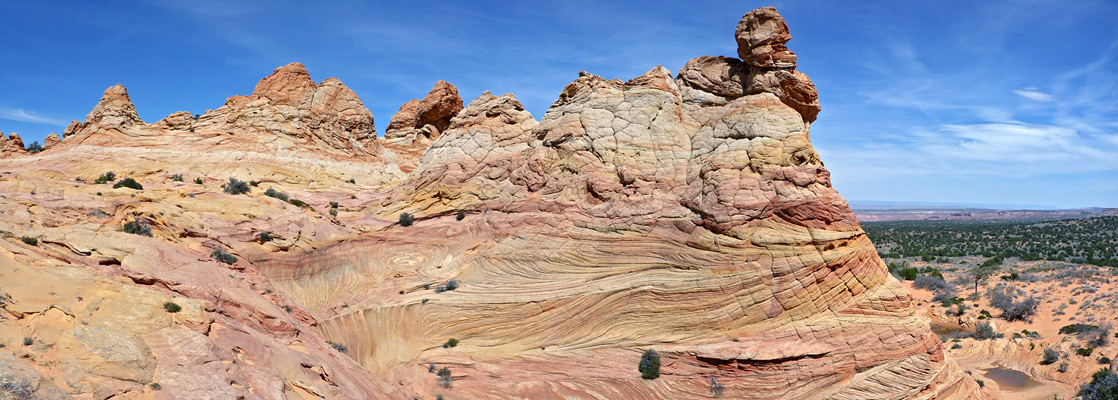
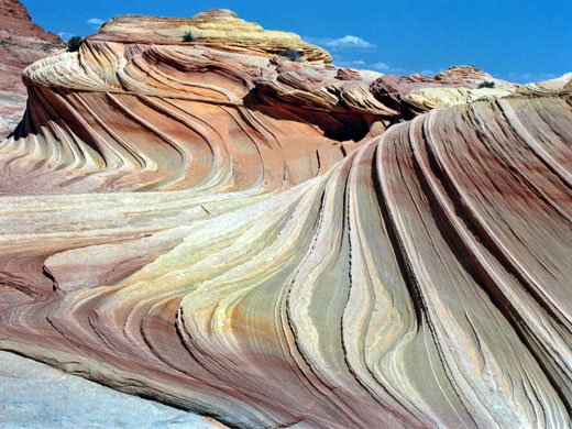
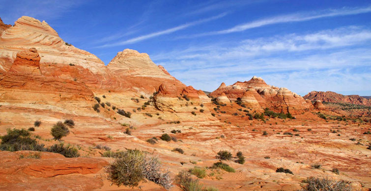
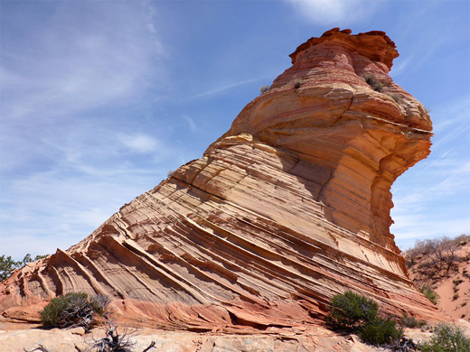
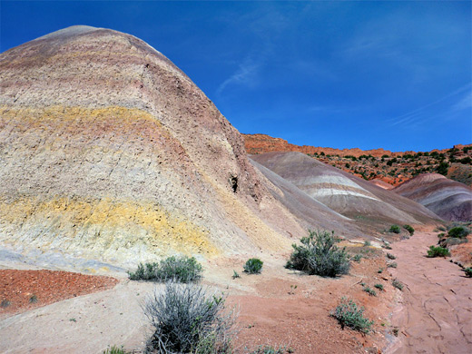
Multicolored, eroded rock formations dominate most of southeast Utah, though particularly outstanding is the desert either side of the Paria River, beneath the Vermilion Cliffs - seen for example along the Cottonwood Canyon Road or at the Paria Rimrocks. The kaleidoscopic scenery extends a little way south into Arizona, before the land becomes more sandy and barren, and all can be visited free of charge and with no access restrictions apart from the Paria Canyon system and one small area spanning the UT/AZ border (mostly in Arizona); this is Coyote Buttes, which was unknown before the mid 1990s but is now quite popular mostly because of just one formation, The Wave, a small ravine between eroded sandstone domes formed of amazingly beautiful rocks containing thin, swirling strata.
The location was first publicized in Germany, in magazine articles and a movie ('Faszination Natur' by Gogol Lobmayr, 1995), and for the following few years was visited only by a small number of Europeans, becoming widely known just in the last decade or so. All the formations are contained within the Paria Canyon-Vermilion Cliffs Wilderness, of which the majority (the Arizona section) is also part of Vermilion Cliffs National Monument. Because the BLM considers the formations to be particularly delicate, Coyote Buttes is subject to fees, entry limitations and other regulations, with visitors having to apply in advance for a small number of daily permits.
The location was first publicized in Germany, in magazine articles and a movie ('Faszination Natur' by Gogol Lobmayr, 1995), and for the following few years was visited only by a small number of Europeans, becoming widely known just in the last decade or so. All the formations are contained within the Paria Canyon-Vermilion Cliffs Wilderness, of which the majority (the Arizona section) is also part of Vermilion Cliffs National Monument. Because the BLM considers the formations to be particularly delicate, Coyote Buttes is subject to fees, entry limitations and other regulations, with visitors having to apply in advance for a small number of daily permits.
Coyote Buttes Table of Contents
Coyote Buttes Map
Map of north and south Coyote Buttes.
Photographs
North, south, west.
Location of the Coyote Buttes
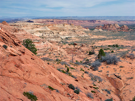
Coyote Buttes are the far southern portion of the Coxcomb Ridge, a 40 mile escarpment that parallels much of the Cottonwood Canyon Road and provides an impressive barrier to US 89 between Kanab and Page. The buttes are reached by House Rock Valley Road which links US 89 with ALT-US 89, south of the Vermilion Cliffs in Arizona. The southern part of this track may have soft sand or mud at some times of the year and a rather longer drive (21 miles vs. 8.5 miles) is required to reach the main Coyote Buttes trailhead, so the northern route is preferred; this still rather bumpy road is also used to reach the Buckskin Gulch slot canyon, and the trailhead for the Wave is the same as for the Wire Pass entrance of the gulch.
North and South Coyote Buttes
The BLM divides the Coyote Buttes into two equally sized sections, North and South (see map). The northern region contains the Wave and most of the other famous sites, and extends from Wire Pass about 4 miles south (2 miles in Utah and 2 miles in Arizona), while the southern half stretches a further 4 miles. Apart from the Wire Pass trailhead, the only other easily reached starting point for Coyote Buttes North is The Notch, 2 miles from Wire Pass, where a trail crosses a pass in the cliffs and leads to the south end of the north section. South Coyote Buttes is generally harder to reach though a lesser quality dirt track provides access from the east, while the very southern end (Paw Hole) can be reached by a 2.6 mile 4WD track starting from Lone Tree Reservoir, along House Rock Valley Road. An alternative way to reach this area is by an off-trail, cross-country hike starting directly from House Rock Valley Road, climbing right over the main ridge; between 2.5 and 3.5 miles, depending on the route. Along here are several sites of interest including Top Rock Spring, a hidden arch, a group of stripy mounds and the tepees of Cottonwood Cove.
Vermilion Cliffs Tours
Coyote Buttes Permits
Permits allowing entry to North or South Coyote Buttes cost $7 per person, with a daily limit of 64 and 20 people for each region respectively, and no more than six in a single group. Actually applying for a permit costs another $9. The system in place for 2024 allocates all permits by online lotteries, of two types; Daily and Advanced. The Daily Lottery is for people actually in the local area and is held two days before the intended visit; there are 16 places for the northern area (The Wave) available, and ten for the south. Most people though use the Advanced Lottery, which is held four months prior; this has 48 and ten places respectively, for north and south. The details of each application are the same for both regions, and are described on the North Coyote Buttes page. All permits are always greatly oversubscribed, sometimes by a factor of a hundred or more. Successful applicants receive a copy of the access regulations and, for North Coyote Buttes, a topographic map to help identify the route to the Wave, which is not so well marked on the ground. Permits are also required for dogs - another $7. No overnight camping is permitted anywhere in the area; the nearest locations for this are along House Rock Valley Road.
Coyote Buttes Hiking
The Wave; North Coyote Buttes
★★★★★
★★★★★
2.6 miles, 400 feet
The trail to the Wave, from where many other formations can be seen close by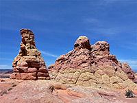
South Coyote Buttes (Cottonwood Spring)
★★★★★
★★★★★
Up to 5 miles, round trip
More dispersed and harder-to-reach formations in the south, explored by a loop hike from a 4WD trailhead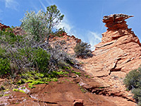
South Coyote Buttes (West)
★★★★★
★★★★★
2.5 miles, or longer
Cross-country routes to South Coyote Buttes from House Rock Valley Road in the west, passing a variety of interesting sitesCoyote Buttes - Nearby Places
- Paria Rimrocks (12 miles) - sculpted formations near the Paria River
- Buckskin Gulch (adjacent) - spectacular 13 mile slot canyon
Coyote Buttes - Similar Places
- White Pocket - amazing formations in a remote region of the Paria Plateau
- Yellow Rock, Grand Staircase-Escalante National Monument, Utah - swirling rock formations
All Contents © Copyright The American Southwest | Comments and Questions | Contribute | Affiliate Marketing Disclosure | Site Map