White Pocket, Vermilion Cliffs National Monument
Arizona > Vermilion Cliffs National Monument > White Pocket
White Pocket
Remote region of the Paria Plateau; swirling, multicolored formations of Navajo sandstone, including domes, hoodoos, gullies and potholes. Reached by a long drive on unpaved roads, some requiring a high clearance 4WD vehicle
Length: around 2 miles (round trip)
Elevation change: up to 200 feet
Difficulty: Easy
Type: Off-trail loop
Usage: Low
Season: All year, unless after heavy rain as the access tracks may be impassable
Trailhead: 16.4 miles along House Rock Valley Road then 11.8 miles on lesser tracks
Rating (1-5): ★★★★★
Elevation change: up to 200 feet
Difficulty: Easy
Type: Off-trail loop
Usage: Low
Season: All year, unless after heavy rain as the access tracks may be impassable
Trailhead: 16.4 miles along House Rock Valley Road then 11.8 miles on lesser tracks
Rating (1-5): ★★★★★

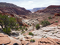
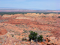
The Paria Plateau is the central geographic feature of Vermillion Cliffs National Monument; a remote, sandy area 20 by 20 miles in size bordered by Buckskin Gulch and the Paria River to the north, the cliffs themselves to the east and south, and House Rock Valley to the west. Some parts are flat, others gently sloping, and the area is crossed only by rough tracks, most requiring a 4WD vehicle due to long stretches of deep, soft sand. Dotted across this generally featureless region are numerous small outcrops of the underlying Navajo sandstone, eroded to form unusually varied shapes, generally colored white or red but mixed with layers of many other shades.
The largest and best known formations are the Coyote Buttes, in the northwest corner of the plateau, including the famous Wave, while the second most visited site is six miles southeast - this is White Pocket, a group of domes and ridges covering an area of one square mile, below a larger mesa lined by similar rocks. A pocket, in this sense, refers to a relatively small area of land markedly different to its surroundings, which here, like most of the plateau, are sandy plains sparsely covered by bushes and small trees.
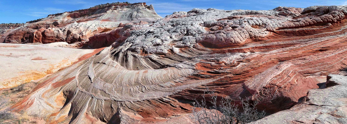
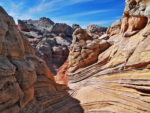
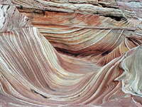
White, or light grey is the dominant rock color at White Pocket, in contrast to the red of the Coyote Buttes, but the general features are similar - swirling, thin-layered strata, adjacent layers of contrasting color, and curious erosive features. Other colorful pockets are found further south and east on the plateau, some also with an official name but most unrecognized. There are several dozen locations, all with the potential to have photogenic formations.
Like Coyote Buttes, some formations at the White Pockets are delicate and could be damaged if subject to a large number of hikers, but there is no permit system and visitation is unlimited; it is however naturally restricted due to the difficulty of access. The main approach to the Paria Plateau is along House Rock Valley Road to the west (see map); an unpaved route generally suitable for regular vehicles except after heavy rain. The usual turn-off for White Pocket is 16.4 miles south of US 89 (13.3 miles north of US 89A) at Lone Tree Reservoir. From here, a track heads southeast then northeast, past Paw Hole (2.6 miles) to a junction at Poverty Flat (5.7 miles), then on to another intersection at an old ranch site (7.6 miles), further east to a third junction (10.4 miles) and finally north to a parking area beside a fence on the east side of the pocket.
There are several difficult, sandy places before and after Poverty Flat, though this place may be reached by an alternative route, free of the deep sand; this involves driving 3.8 miles further south along House Rock Valley then east, across Corral Valley, turning north at the first major junction, past the generally uninteresting Red Pocket (6.2 miles) and on to the flat (15 miles). The first sandy section is a mile or so further, but non-4WD visitors are now within hiking distance of White Pocket, around 3 miles along the track or 2 miles partly cross country. Very determined hikers could reach the place via a strenuous hike of about 8 miles, starting directly from House Rock Valley, while another option is to take an all-day guided tour, which in 2024 costs around $220 per person. The roads to Poverty Flat also form part of the route to the Cottonwood Cove region of South Coyote Buttes.
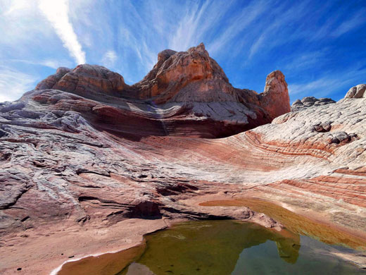
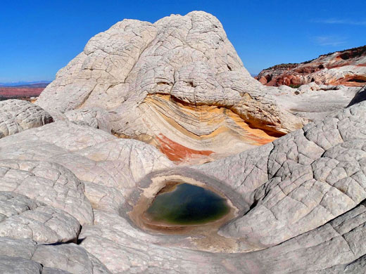
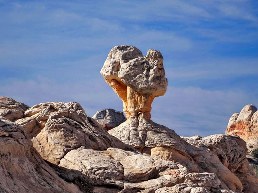
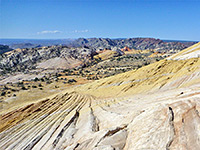
The closest formations to the end of the road are 1,000 feet west, part of a broad, low relief ridge of white sandstone which to the north approaches taller white cliffs at the edge of a mesa and to the south breaks up to a series of little domes and outcrops of 'brain rocks' - curving surfaces split by deep cracks into irregular polygonal shapes. The ridge has various gullies, wave-like formations and potholes that retain water for a long time after rain. A quarter of a mile west is a smaller but higher white hill, the actual White Pocket, with similar forms and features, centered on a thin ridge rising up to 450 feet above the surroundings. All the major features in both sites can be seen in a couple of hours, walking between 2 and 3 miles, but as usual with this kind of intricate landscape, much more time can be spent looking into all the little ravines and crevices, and waiting for the best light conditions.
The largest and best known formations are the Coyote Buttes, in the northwest corner of the plateau, including the famous Wave, while the second most visited site is six miles southeast - this is White Pocket, a group of domes and ridges covering an area of one square mile, below a larger mesa lined by similar rocks. A pocket, in this sense, refers to a relatively small area of land markedly different to its surroundings, which here, like most of the plateau, are sandy plains sparsely covered by bushes and small trees.
White, or light grey is the dominant rock color at White Pocket, in contrast to the red of the Coyote Buttes, but the general features are similar - swirling, thin-layered strata, adjacent layers of contrasting color, and curious erosive features. Other colorful pockets are found further south and east on the plateau, some also with an official name but most unrecognized. There are several dozen locations, all with the potential to have photogenic formations.
White Pocket Table of Contents
- Route map; approaches from House Rock Valley
- Tours to the White Pocket
- White Pocket FAQ
- Access from the north, via Paw Hole
- Access from the south, via Corral Valley
- The formations
- Similar places
Route Map
Map of driving routes to White Pocket and South Coyote Buttes
Selected tours to White Pocket:
White Pocket Tours
Selected tours to White Pocket:
White Pocket FAQ
- A pocket is a small area of land markedly different to its surroundings, usually rocky, as in this case, where the rocks are predominantly white or pale grey, surrounded by sandy flats.
- The Lower Unit of the Navajo sandstone, which is mainly white in color, but stained shades of red, orange and pink by iron oxide.
- No, unlike the nearby Wave (Coyote Buttes), there are no restrictions, in part because of the difficulty of getting here, so visitor numbers are likely always to remain low.
- There are two outcrops of exposed rocks; that closest to the trailhead is nearly a mile across, and a quarter of a mile wide, while a little further west is a second, smaller area, half a mile by a quarter of a mile.
- The usual approach is from US 89 in the north, from where the distance to the trailhead is 34 or 28 miles depending on the route; the drive typically takes between 90 and 120 minutes. The pocket can also be reached from US 89A to the south; distance 15 miles, taking around 70 minutes.
- Self-driving is a good option for people with capable high clearance 4WD vehicles, due to long stretches of soft sand on the approach roads; for all others a tour is by far the best option, though in theory the pocket can be reached on foot after a hike of around 3 miles, starting from a place accessible to 2WD vehicles, before the sandiest sections. If people do drive, and get stuck, it can cost upwards of $1000 to get rescued.
- Dreamland Safari Tours, Kanab Tour Company, ROAM Outdoors, Coral Cliffs Tours of Kanab, Paria Outpost & Oufitters.
- Yes, there are no restrictions at the pocket itself, though drones are not allowed in the area east of the trailhead since that is within the Paria Canyon-Vermilion Cliffs Wilderness Area.
- Limited; AT&T have the best coverage, T-Mobile and Verizon less so.
- Yes, along the approach roads - the surroundings are public BLM land. Although technically permitted at the trailhead, campers are asked not to stay here, to keep this area clear for regular visitors.
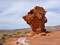
- Elsewhere on the Paria Plateau are smaller Navajo sandstone outcrops such as Hole in the Rock, Joe's Tank and The Beehives, plus others unnamed, while more well known areas are Coyote Buttes (North and South) and Edmaiers Secret.
White Pocket Access, Via Paw Hole
Like Coyote Buttes, some formations at the White Pockets are delicate and could be damaged if subject to a large number of hikers, but there is no permit system and visitation is unlimited; it is however naturally restricted due to the difficulty of access. The main approach to the Paria Plateau is along House Rock Valley Road to the west (see map); an unpaved route generally suitable for regular vehicles except after heavy rain. The usual turn-off for White Pocket is 16.4 miles south of US 89 (13.3 miles north of US 89A) at Lone Tree Reservoir. From here, a track heads southeast then northeast, past Paw Hole (2.6 miles) to a junction at Poverty Flat (5.7 miles), then on to another intersection at an old ranch site (7.6 miles), further east to a third junction (10.4 miles) and finally north to a parking area beside a fence on the east side of the pocket.
Southern Route, via Corral Valley
There are several difficult, sandy places before and after Poverty Flat, though this place may be reached by an alternative route, free of the deep sand; this involves driving 3.8 miles further south along House Rock Valley then east, across Corral Valley, turning north at the first major junction, past the generally uninteresting Red Pocket (6.2 miles) and on to the flat (15 miles). The first sandy section is a mile or so further, but non-4WD visitors are now within hiking distance of White Pocket, around 3 miles along the track or 2 miles partly cross country. Very determined hikers could reach the place via a strenuous hike of about 8 miles, starting directly from House Rock Valley, while another option is to take an all-day guided tour, which in 2024 costs around $220 per person. The roads to Poverty Flat also form part of the route to the Cottonwood Cove region of South Coyote Buttes.
The Formations
The closest formations to the end of the road are 1,000 feet west, part of a broad, low relief ridge of white sandstone which to the north approaches taller white cliffs at the edge of a mesa and to the south breaks up to a series of little domes and outcrops of 'brain rocks' - curving surfaces split by deep cracks into irregular polygonal shapes. The ridge has various gullies, wave-like formations and potholes that retain water for a long time after rain. A quarter of a mile west is a smaller but higher white hill, the actual White Pocket, with similar forms and features, centered on a thin ridge rising up to 450 feet above the surroundings. All the major features in both sites can be seen in a couple of hours, walking between 2 and 3 miles, but as usual with this kind of intricate landscape, much more time can be spent looking into all the little ravines and crevices, and waiting for the best light conditions.
White Pocket - Similar Hikes
All Contents © Copyright The American Southwest | Comments and Questions | Contribute | Affiliate Marketing Disclosure | Site Map