Western Approach to South Coyote Buttes
Cross-country routes to South Coyote Buttes from House Rock Valley Road in the west, passing a variety of interesting sites including Top Rock Spring, Cottonwood Cove, stripy badlands, a narrow ravine and a hidden arch
Length: Between 2.5 and 3.5 miles one way, depending on the route
Elevation change: 900 feet
Difficulty: Moderate to strenuous; route finding, scrambling
Type: One way, off trail
Usage: Low; visitor numbers are restricted, to 20 per day. Permits are required
Season: All year (except after rain), though summers are very hot
Trailhead: End of a short track off House Rock Valley Road
Rating (1-5): ★★★★★

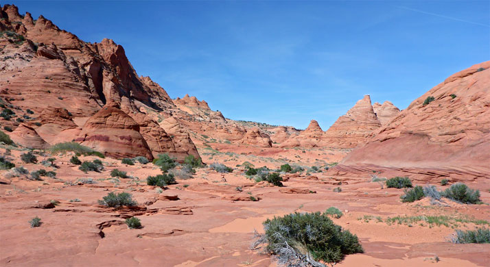
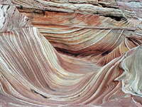
The more remote, southern section of Coyote Buttes is much less popular than the northern part, yet even here the 20 daily permits are also usually reserved many weeks in advance. The best formations are along the rim of a steep slope on the southeast side of Cottonwood Spring, reached by a short walk from the trailhead parking area, 8 miles from House Rock Valley along sometimes very sandy tracks that always require high clearance, 4WD vehicles.
For 2WD drivers, one alternative is to park at Paw Hole at the far southern end of the Coyote Buttes ridge, accessed by a track which is still somewhat sandy, then hike northwards, cross-country for 3 miles, while another, detailed below, is to start from House Rock Valley and walk east, right over the high point of the ridge and down towards the formations. This has the advantage of much easier vehicular access, directly from the main road, though even here the surface can be impassable when wet.
There are various options as to the exact hiking route to the Cottonwood Spring area from House Rock Valley; the two described below allow for a loop hike to the formations of about 8 miles, approaching via Top Rock Spring in the north, and returning through Cottonwood Cove further south. In addition to these two locations - an unusual, elevated spring, and a rocky drainage lined by sandstone cliffs, the loop also passes several other features of interest including a slender double arch, a slot-like, red rock chamber, and a band of stripy, pastel-colored badlands. The terrain is mostly not too difficult but the hike as a whole is quite strenuous, requiring route finding and some scrambling over steep slopes, with moderate exposure.
A suitable parking place for the western approach to South Coyote Buttes is the end of a very short track on the east side of House Rock Valley Road 12 miles south of US 89, on a low bench beside Coyote Wash. The road is generally accessible for most vehicles including small RVs, but not in wet weather. The first few miles from US 89 are rather stony, up to a pass and down to the crossing of Buckskin Gulch, then the surface improves over the next few miles as far as the Wire Pass trailhead, the usual start point for hikes to North Coyote Buttes and the Wave. The next section is generally flatter, sometimes quite smooth, though also liable to be rutted. The side track is also a good primitive camping spot, shielded from the road, and with expansive views east towards the Coyote Buttes ridge.
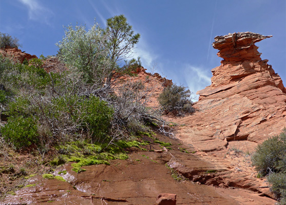
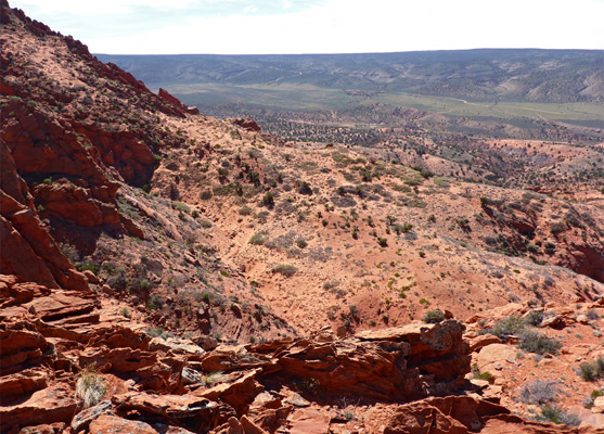
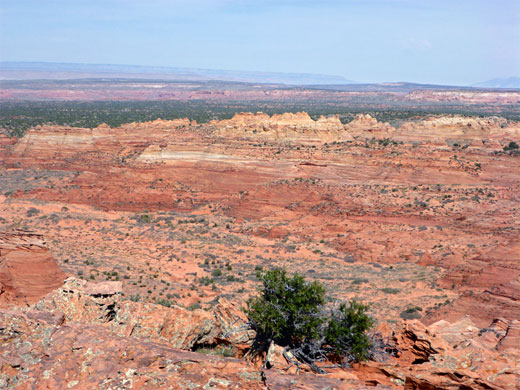
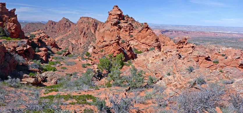
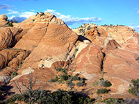
A minor drainage provides an easy route for about two thirds of the distance to the ridge, forking east off Coyote Wash just south of the parking area. Footprints suggests this is used fairly regularly, as does a BLM notice that marks the boundary of the Paria Canyon-Vermilion Cliffs Wilderness, and also states the need to be in possession of a Coyote Buttes permit if entering the restricted zone, the west edge of which is about one mile ahead. The dry wash winds round a few bends then straightens, leading to a dryfall in the middle of an intermediate ridge, which becomes significantly higher to the north. The fall is passed by climbing up a sandy slope to the south, then dropping back down, across a south fork of the drainage, and continuing up the main fork, which soon divides again. The easiest route to the ridgetop seems to be along the left fork briefly, then up the steep rock slope beyond, aiming for the top of a sandier slope, traversing sideways near the top and finally ascending a short gully to the crest; a broad, flat area that affords the first views of the formations around Cottonwood Spring and the expansive country of the Paria Plateau beyond.
A brief northwards descent down a gully reaches a basin just above Top Rock Spring, a semi-permanent water source that is unusual for its elevated position, 600 feet above the valley floor to the east. The waters emerge beneath a dense clump of vegetation that includes a tall pine tree and lots of bright green moss, and while most soon sinks underground, the shallow ravine below is usually wet for several hundred feet. A few very shallow pools provide drinkable water. From the spring it is an easy 0.6 mile walk over flattish, sandy terrain to the nearest tepee formations, on the west side of Cottonwood Spring, or 1.2 miles to the most popular area, higher up on the far side of the valley.
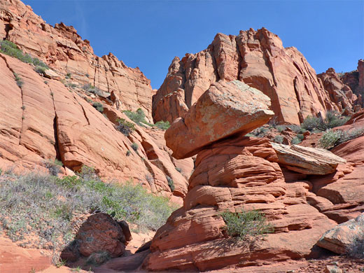
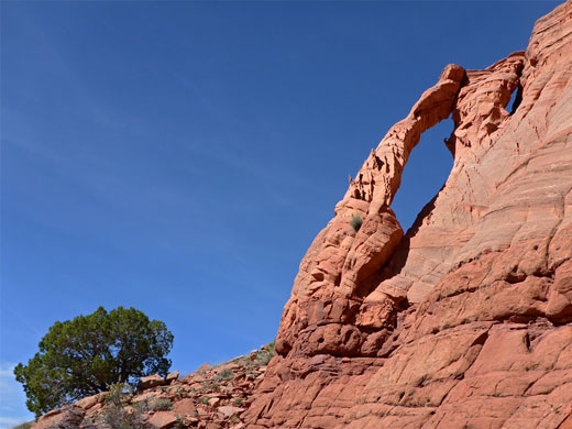
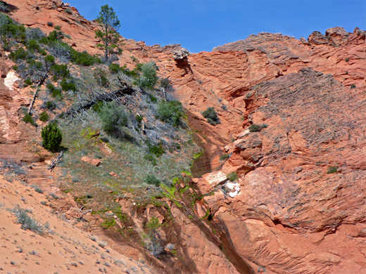
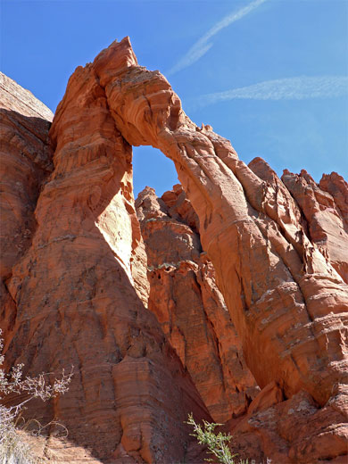
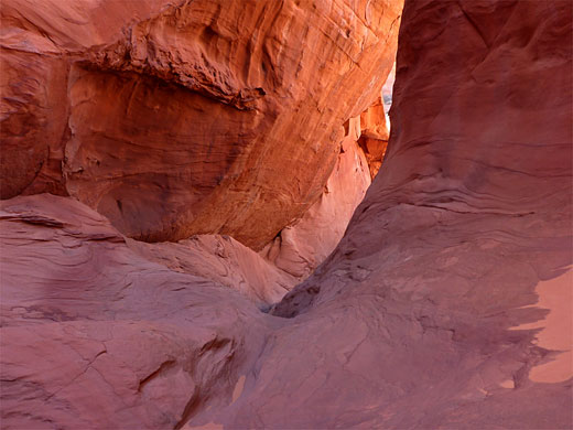
The southern route from the Cottonwood Spring formations to House Rock Valley first involves descending about 400 feet to the valley floor, down smooth, steep slickrock slopes, then walking southwest along a wide, sandy wash, and over a short, bushy patch to another wash, which leads into Cottonwood Cove. The cove has one large group of red tepees just north of the wash, though the rocks are uniformly colored deep red, and the formations are not so interesting as those further east. At the upper (south) end of the basin, the wash forms a short but photogenic, slot-like passage between smooth red cliffs, then opens out to a broad expanse of rock benches and slopes, which allow easy climbing, veering west and later northwest, up towards the ridgetop. The uppermost section is a little more difficult to traverse, and the steeper terrain makes it harder to identify a good route. Once on top, again there are several choices as to the way down, but the most direct is to walk a little way south and descend a short ravine, containing several dryfalls. A less steep, sandier slope to the north provides an easier route, however the ravine is also notable for a slender double arch near its lower end. The main span is maybe 30 feet tall, formed by a narrow fin leaning against a second fin, which forms a much smaller arch at the top. The shadow created by the main arch by the afternoon sun can just be seen from the road, through House Rock Valley, though it seems the arch has not previously been observed.
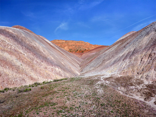
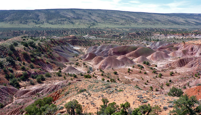
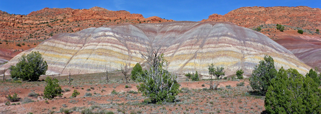
The small drainage below the arch provides the first part of the route back to the start point; an alternately sandy and rocky ravine containing a few dryfalls, which need diversions to pass. The wash later curves westwards, leaving a more direct route cross-country, at first over a fairly flat ridge then quite steeply down to a line of mounds and undulating hills along the east side of Coyote Wash, formed of soft rocks of the Chinle Formation, here colored many pastel shades of pink, yellow, purple and orange. Known informally as the rainbow badlands, these are part of a gently curving outcrop nearly a mile long, and a couple of hours could be spent exploring. In spring the otherwise barren slopes are covered with innumerable tiny parsley flowers. The edge of the badlands is less than half a mile from the parking area along House Rock Valley Road.
For 2WD drivers, one alternative is to park at Paw Hole at the far southern end of the Coyote Buttes ridge, accessed by a track which is still somewhat sandy, then hike northwards, cross-country for 3 miles, while another, detailed below, is to start from House Rock Valley and walk east, right over the high point of the ridge and down towards the formations. This has the advantage of much easier vehicular access, directly from the main road, though even here the surface can be impassable when wet.
There are various options as to the exact hiking route to the Cottonwood Spring area from House Rock Valley; the two described below allow for a loop hike to the formations of about 8 miles, approaching via Top Rock Spring in the north, and returning through Cottonwood Cove further south. In addition to these two locations - an unusual, elevated spring, and a rocky drainage lined by sandstone cliffs, the loop also passes several other features of interest including a slender double arch, a slot-like, red rock chamber, and a band of stripy, pastel-colored badlands. The terrain is mostly not too difficult but the hike as a whole is quite strenuous, requiring route finding and some scrambling over steep slopes, with moderate exposure.
House Rock Valley Road
A suitable parking place for the western approach to South Coyote Buttes is the end of a very short track on the east side of House Rock Valley Road 12 miles south of US 89, on a low bench beside Coyote Wash. The road is generally accessible for most vehicles including small RVs, but not in wet weather. The first few miles from US 89 are rather stony, up to a pass and down to the crossing of Buckskin Gulch, then the surface improves over the next few miles as far as the Wire Pass trailhead, the usual start point for hikes to North Coyote Buttes and the Wave. The next section is generally flatter, sometimes quite smooth, though also liable to be rutted. The side track is also a good primitive camping spot, shielded from the road, and with expansive views east towards the Coyote Buttes ridge.
Route to the Ridgetop
A minor drainage provides an easy route for about two thirds of the distance to the ridge, forking east off Coyote Wash just south of the parking area. Footprints suggests this is used fairly regularly, as does a BLM notice that marks the boundary of the Paria Canyon-Vermilion Cliffs Wilderness, and also states the need to be in possession of a Coyote Buttes permit if entering the restricted zone, the west edge of which is about one mile ahead. The dry wash winds round a few bends then straightens, leading to a dryfall in the middle of an intermediate ridge, which becomes significantly higher to the north. The fall is passed by climbing up a sandy slope to the south, then dropping back down, across a south fork of the drainage, and continuing up the main fork, which soon divides again. The easiest route to the ridgetop seems to be along the left fork briefly, then up the steep rock slope beyond, aiming for the top of a sandier slope, traversing sideways near the top and finally ascending a short gully to the crest; a broad, flat area that affords the first views of the formations around Cottonwood Spring and the expansive country of the Paria Plateau beyond.
Top Rock Spring
A brief northwards descent down a gully reaches a basin just above Top Rock Spring, a semi-permanent water source that is unusual for its elevated position, 600 feet above the valley floor to the east. The waters emerge beneath a dense clump of vegetation that includes a tall pine tree and lots of bright green moss, and while most soon sinks underground, the shallow ravine below is usually wet for several hundred feet. A few very shallow pools provide drinkable water. From the spring it is an easy 0.6 mile walk over flattish, sandy terrain to the nearest tepee formations, on the west side of Cottonwood Spring, or 1.2 miles to the most popular area, higher up on the far side of the valley.
Cottonwood Cove
The southern route from the Cottonwood Spring formations to House Rock Valley first involves descending about 400 feet to the valley floor, down smooth, steep slickrock slopes, then walking southwest along a wide, sandy wash, and over a short, bushy patch to another wash, which leads into Cottonwood Cove. The cove has one large group of red tepees just north of the wash, though the rocks are uniformly colored deep red, and the formations are not so interesting as those further east. At the upper (south) end of the basin, the wash forms a short but photogenic, slot-like passage between smooth red cliffs, then opens out to a broad expanse of rock benches and slopes, which allow easy climbing, veering west and later northwest, up towards the ridgetop. The uppermost section is a little more difficult to traverse, and the steeper terrain makes it harder to identify a good route. Once on top, again there are several choices as to the way down, but the most direct is to walk a little way south and descend a short ravine, containing several dryfalls. A less steep, sandier slope to the north provides an easier route, however the ravine is also notable for a slender double arch near its lower end. The main span is maybe 30 feet tall, formed by a narrow fin leaning against a second fin, which forms a much smaller arch at the top. The shadow created by the main arch by the afternoon sun can just be seen from the road, through House Rock Valley, though it seems the arch has not previously been observed.
Badlands
The small drainage below the arch provides the first part of the route back to the start point; an alternately sandy and rocky ravine containing a few dryfalls, which need diversions to pass. The wash later curves westwards, leaving a more direct route cross-country, at first over a fairly flat ridge then quite steeply down to a line of mounds and undulating hills along the east side of Coyote Wash, formed of soft rocks of the Chinle Formation, here colored many pastel shades of pink, yellow, purple and orange. Known informally as the rainbow badlands, these are part of a gently curving outcrop nearly a mile long, and a couple of hours could be spent exploring. In spring the otherwise barren slopes are covered with innumerable tiny parsley flowers. The edge of the badlands is less than half a mile from the parking area along House Rock Valley Road.
South Coyote Buttes - Similar Hikes
All Contents © Copyright The American Southwest | Comments and Questions | Contribute | Affiliate Marketing Disclosure | Site Map