Cosmic Ashtray, Grand Staircase-Escalante National Monument
Utah > Grand Staircase-Escalante National Monument > Cosmic Ashtray
Cosmic Ashtray
Cosmic Ashtray, The Volcano, or the Inselberg Pit - a huge, sand-filled crater, ringed by partly overhanging cliffs, with a rock pillar at the center; created by wind erosion. Reached by a cross-country route, over sand and slickrock
Length: 4.6 miles
Elevation change: 200 feet
Difficulty: Moderate; requires route-finding
Type: One way, off trail, unmarked route
Usage: Low
Season: All year, though exposed and hot in summer
Trailhead: 5.8 miles along Old Sheffield Road
Rating (1-5): ★★★★★
Elevation change: 200 feet
Difficulty: Moderate; requires route-finding
Type: One way, off trail, unmarked route
Usage: Low
Season: All year, though exposed and hot in summer
Trailhead: 5.8 miles along Old Sheffield Road
Rating (1-5): ★★★★★

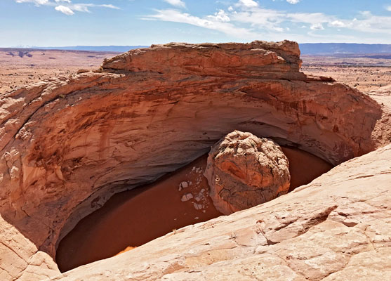
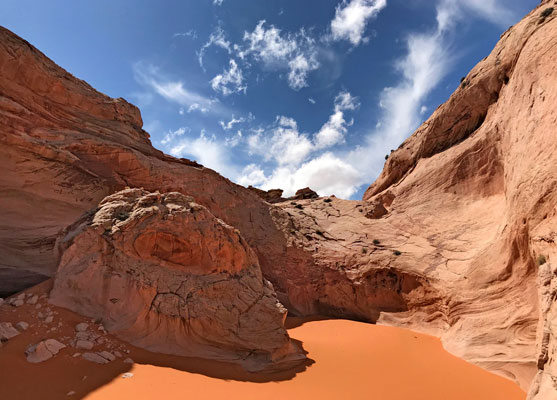
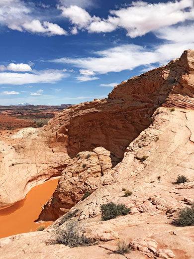
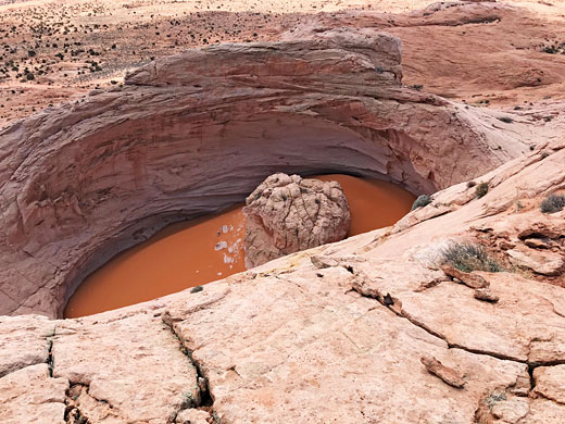
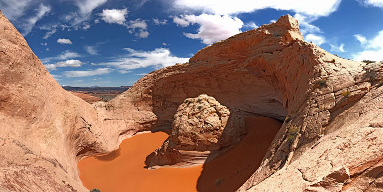
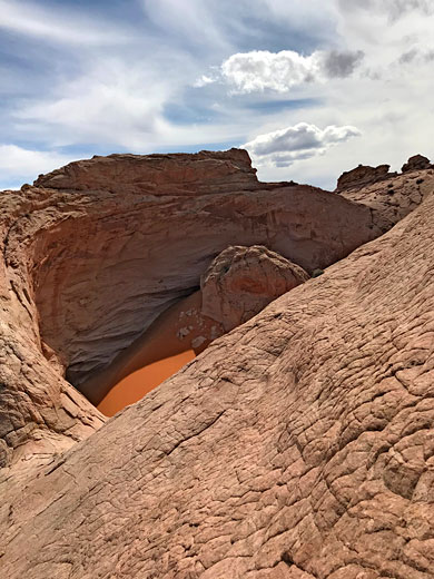
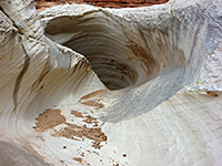
The Cosmic Ashtray, the Cosmic Navel, The Volcano and the Inselberg Pit, are some of the names given to an unusual geological feature in the vast Navajo sandstone plateau east of the Escalante River - a huge, circular, cliff-lined depression, filled with bright orange sand and centered on a rock pinnacle, resembling a dinosaur skull. The pit is 200 feet across and up to 60 feet deep, the result of erosion over the millennia by the prevailing southwesterly winds and the sands they carry. Inselberg is a German word meaning 'island mountain', here seemingly referring to the central pinnacle.
The official term of the formation is a cyclonic weathering pit, and this is considered to be the best example on Earth. It has formed in a gap between two minor peaks, along the ridge to the northeast of a large, low relief basin bisected by the various forks of Red Breaks; the wind blows across the basin and through the gap, where unevenness in the surface generates a circular motion, and this has led to the formation of the crater, which is still being actively enlarged. Having attained this great size, the hollow now draws in the wind due to differences in pressure, and thus the rate of enlargement increases.
The pit has a remote location, over eight miles from a paved road but may be accessed relatively easily, by driving 5.8 miles along a track, the unpaved Old Sheffield Road, and then a hike of 4 miles, across open sand and slickrock with only minor changes in elevation. Moqui steps have been constructed down in the lowest portion of the enclosing cliffs, allow scrambling down to the deep, coarse sand on the floor of the pit, while walking all around the rim allows viewing of the crater from all angles.
Topographic map of the Cosmic Ashtray, and the Red Breaks drainage.
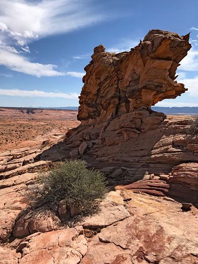
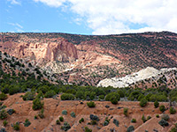
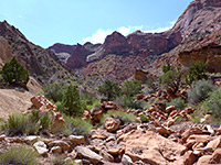
Old Sheffield Road leaves Highway 12 just south of its dramatic descent towards the Escalante River, and heads east, following the rim of a low plateau then crossing a large grassy area (Big Spencer Flats), up to a junction, with a track to the south. A sign advises that vehicles are prohibited from continuing, so the hike begins from here - initially along the eastwards continuation of the track until it approaches a sandy wash, 1.6 miles from the junction, then ends not far ahead in the vicinity of Spencer Canyon. The unmarked route to the pit is firstly across the wash and then southeastwards over slickrock at the base of a low ridge to the south, staying almost level at around 5,700 feet, past the upper ends of a few drainages, until, 3.8 miles from the road junction, veering due south below a white dome to the west, and ending 0.8 miles further with a climb of about 150 feet up a cross-bedded slope, approaching the pit from the east side, shortly after the bedrock changes color from orange to pale grey.
The walls of the pit are high to the north and south, low again to the west, and here, the direction of the prevailing wind is evident from a sizable groove in the bedrock, enlarged and worn smooth by the Aeolian currents. The pit can also be reached by a much shorter walk, 0.8 miles, from the south, but this involves a ten mile drive on a sandy road, the last few miles of which, from shortly before Harris Wash, require 4WD.
The official term of the formation is a cyclonic weathering pit, and this is considered to be the best example on Earth. It has formed in a gap between two minor peaks, along the ridge to the northeast of a large, low relief basin bisected by the various forks of Red Breaks; the wind blows across the basin and through the gap, where unevenness in the surface generates a circular motion, and this has led to the formation of the crater, which is still being actively enlarged. Having attained this great size, the hollow now draws in the wind due to differences in pressure, and thus the rate of enlargement increases.
The pit has a remote location, over eight miles from a paved road but may be accessed relatively easily, by driving 5.8 miles along a track, the unpaved Old Sheffield Road, and then a hike of 4 miles, across open sand and slickrock with only minor changes in elevation. Moqui steps have been constructed down in the lowest portion of the enclosing cliffs, allow scrambling down to the deep, coarse sand on the floor of the pit, while walking all around the rim allows viewing of the crater from all angles.
Map
Topographic map of the Cosmic Ashtray, and the Red Breaks drainage.
Excursion to the Cosmic Ashtray
Route to the Pit
Old Sheffield Road leaves Highway 12 just south of its dramatic descent towards the Escalante River, and heads east, following the rim of a low plateau then crossing a large grassy area (Big Spencer Flats), up to a junction, with a track to the south. A sign advises that vehicles are prohibited from continuing, so the hike begins from here - initially along the eastwards continuation of the track until it approaches a sandy wash, 1.6 miles from the junction, then ends not far ahead in the vicinity of Spencer Canyon. The unmarked route to the pit is firstly across the wash and then southeastwards over slickrock at the base of a low ridge to the south, staying almost level at around 5,700 feet, past the upper ends of a few drainages, until, 3.8 miles from the road junction, veering due south below a white dome to the west, and ending 0.8 miles further with a climb of about 150 feet up a cross-bedded slope, approaching the pit from the east side, shortly after the bedrock changes color from orange to pale grey.
The Pit
The walls of the pit are high to the north and south, low again to the west, and here, the direction of the prevailing wind is evident from a sizable groove in the bedrock, enlarged and worn smooth by the Aeolian currents. The pit can also be reached by a much shorter walk, 0.8 miles, from the south, but this involves a ten mile drive on a sandy road, the last few miles of which, from shortly before Harris Wash, require 4WD.
Cosmic Ashtray - Similar Hikes
All Contents © Copyright The American Southwest | Comments and Questions | Contribute | Affiliate Marketing Disclosure | Site Map