

Mansard Trail
Hike into the Vermilion Cliffs east of Kanab, up to a sandy plateau and on to an alcove at the base of a mesa, where a sloping rockface is adorned with petroglyphs and pictographs. Grand views over the Arizona Strip
Length: 2.2 miles
Elevation change: 820 feet
Difficulty: Moderate
Type: One way
Usage: Low to medium
Season: All year
Trailhead: End of a short track off Rock Ledge Lane, 1 mile from US 89
Rating (1-5): ★★★★★
Elevation change: 820 feet
Difficulty: Moderate
Type: One way
Usage: Low to medium
Season: All year
Trailhead: End of a short track off Rock Ledge Lane, 1 mile from US 89
Rating (1-5): ★★★★★

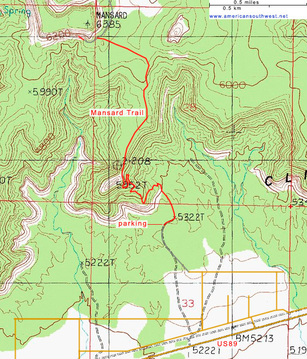
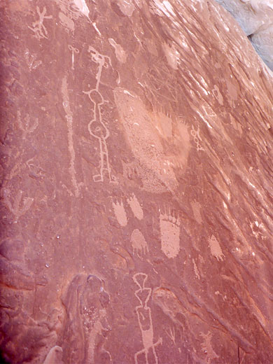
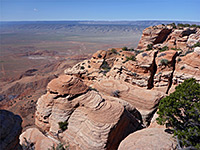
Six miles east of Kanab, just off US 89, the 2.2 mile Mansard Trail is a relatively popular route, with a BLM-maintained trailhead. Starting in the flat lands at the edge of the Arizona Strip district, the path climbs the red rocks of the Vermilion Cliffs, then crosses a sandy plateau towards the base of an isolated, flat-topped peak - Mansard Mesa, ending at an elevated alcove with grand views south, and with the added interest of a large assortment of petroglyphs and pictographs. These are etched, unusually, on a sloping rock face angled at around 20 degrees from horizontal, in contrast to the great majority of such rock art which is on vertical cliffs or the sides of boulders.
The hike gains 820 feet in elevation, mostly towards the start, as it climbs the cliffs, and is fairly easy, especially once on the plateau. Wildflower species are quite numerous, and the geology varied; the route rises through seven different strata groups, and passes a few photogenic eroded formations.
The peak after which the trail is named is presumably so-called because of its resemblance to a mansard, a type of roof with flat top and sides of two differing angles, ultimately deriving from the French architect François Mansart, 1598-1666.
The Mansard Trail is reached driving along residential streets for nearly a mile, on the north side of US 89, the last one Rock Ledge Lane, which leads to a short, unpaved track ending at the trailhead parking area, elevation 5,320 feet, at the foot of the Vermilion Cliffs.
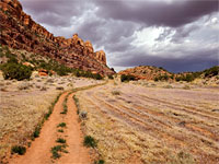
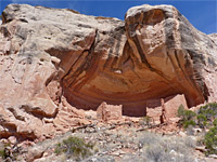
The Mansard Trail starts by winding through bushy, earthen hills - barren mounds and little ravines, from the Dinosaur Canyon Member of the Moenave Formation, then rises a little more steeply through successive red ledges - briefly of the Whitmore Point Member of the Moenave, and into the more extensive Springdale Sandstone Member of the Kayenta Formation, though all these three layers are similar in appearance. The route cuts briefly south to a promontory, and north again, steepening, and approaching the main section of the Vermilion Cliffs where the individual layers are thickest and most vertical. A short traverse southwards followed by another climb takes the path to a saddle between two thin red buttes, the rocks now the main component of the Kayenta Formation.
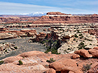
Another brief climb reaches the sandy plateau, where the ground is initially reddish, later becoming white to pale yellow, as the bedrock changes once more, now the Lamb Point Tongue of the Navajo sandstone. The land rises a little, flattens, and rises again, through some sand dunes, and meets a 4WD track, which ends a short distance west, directly below Mansard Mesa. This track enables suitably equipped vehicles to drive here, a trip of around 16 miles, starting along Johnson Canyon Road. Beside the track is a notice about the Mansard site, which is just 250 feet away, along a westwards path.
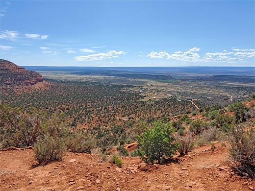
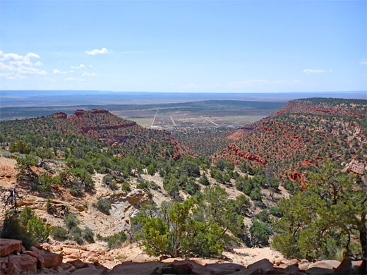
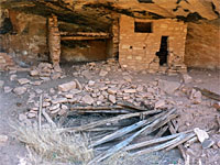
Part of the cliffs all around the sides of Mansard Mesa are formed of pale brown sandstone from the Tenney Canyon Tongue of the Kayenta Formation, while all the top is white Navajo sandstone; it is not quite clear which of these two comprise the rocks around the alcove at the end of the trail. The alcove is not so obvious, properly visible only when directly below, and a faint path continuing west suggests that some people fail to notice the site. The alcove is equipped with a BLM trail register, which indicates that up to a couple of dozen people may visit here on busy days. Hikers are asked not to walk on the petroglyph rockface, which is quite large, maybe 40 feet across, with many dozen individual designs. The southwards views span nearly 180 degrees of the horizon; west, south and east, across the Kaibab Plateau towards the distant cliffs of the Grand Canyon.
The hike gains 820 feet in elevation, mostly towards the start, as it climbs the cliffs, and is fairly easy, especially once on the plateau. Wildflower species are quite numerous, and the geology varied; the route rises through seven different strata groups, and passes a few photogenic eroded formations.

The peak after which the trail is named is presumably so-called because of its resemblance to a mansard, a type of roof with flat top and sides of two differing angles, ultimately deriving from the French architect François Mansart, 1598-1666.
The Mansard Trail is reached driving along residential streets for nearly a mile, on the north side of US 89, the last one Rock Ledge Lane, which leads to a short, unpaved track ending at the trailhead parking area, elevation 5,320 feet, at the foot of the Vermilion Cliffs.
Start of the Trail
The Mansard Trail starts by winding through bushy, earthen hills - barren mounds and little ravines, from the Dinosaur Canyon Member of the Moenave Formation, then rises a little more steeply through successive red ledges - briefly of the Whitmore Point Member of the Moenave, and into the more extensive Springdale Sandstone Member of the Kayenta Formation, though all these three layers are similar in appearance. The route cuts briefly south to a promontory, and north again, steepening, and approaching the main section of the Vermilion Cliffs where the individual layers are thickest and most vertical. A short traverse southwards followed by another climb takes the path to a saddle between two thin red buttes, the rocks now the main component of the Kayenta Formation.

The Plateau
Another brief climb reaches the sandy plateau, where the ground is initially reddish, later becoming white to pale yellow, as the bedrock changes once more, now the Lamb Point Tongue of the Navajo sandstone. The land rises a little, flattens, and rises again, through some sand dunes, and meets a 4WD track, which ends a short distance west, directly below Mansard Mesa. This track enables suitably equipped vehicles to drive here, a trip of around 16 miles, starting along Johnson Canyon Road. Beside the track is a notice about the Mansard site, which is just 250 feet away, along a westwards path.

The Alcove
Part of the cliffs all around the sides of Mansard Mesa are formed of pale brown sandstone from the Tenney Canyon Tongue of the Kayenta Formation, while all the top is white Navajo sandstone; it is not quite clear which of these two comprise the rocks around the alcove at the end of the trail. The alcove is not so obvious, properly visible only when directly below, and a faint path continuing west suggests that some people fail to notice the site. The alcove is equipped with a BLM trail register, which indicates that up to a couple of dozen people may visit here on busy days. Hikers are asked not to walk on the petroglyph rockface, which is quite large, maybe 40 feet across, with many dozen individual designs. The southwards views span nearly 180 degrees of the horizon; west, south and east, across the Kaibab Plateau towards the distant cliffs of the Grand Canyon.
Map of the Mansard Trail

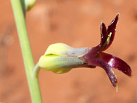
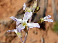
Mansard Wildflowers
More plants along the trail
 Utah penstemon |
 Heartleaf twistflower |
 Desert rockcress |
More plants along the trail
Mansard Trail - Similar Hikes
All Contents © Copyright The American Southwest | Comments and Questions | Contribute | Affiliate Marketing Disclosure | Site Map