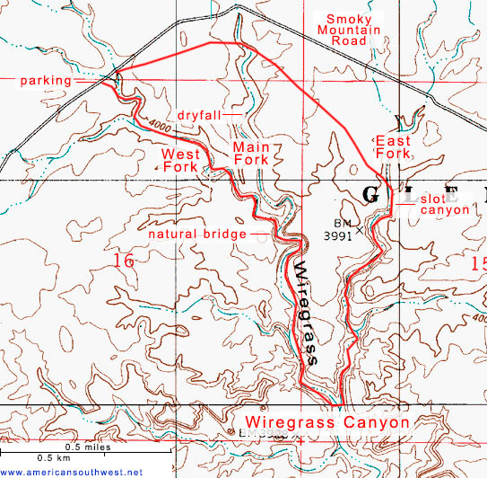
Wiregrass Canyon
Wiregrass is a relatively minor drainage on the north side of Lake Powell, through dull, light-colored rock. The usual hike here is to a small natural bridge, at the junction of a side ravine, while a longer option is to continue further downstream, then up another fork to the east, which forms a short, deep slot at its upper end
Length: 0.9 miles to the bridge, 3.2 miles round trip including the east fork slot
Elevation change: 150 feet, 220 feet
Difficulty: Easy, strenuous (if climbing through the slot)
Type: One-way or round trip, mostly off-trail
Usage: Low
Season: Fall, winter, spring are best; summers are hot
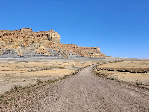
Trailhead: Pullout along Smoky Mountain Road, 4.8 miles from Big Water along US 89
Rating (1-5): ★★★★★
Elevation change: 150 feet, 220 feet
Difficulty: Easy, strenuous (if climbing through the slot)
Type: One-way or round trip, mostly off-trail
Usage: Low
Season: Fall, winter, spring are best; summers are hot
Trailhead: Pullout along Smoky Mountain Road, 4.8 miles from Big Water along US 89
Rating (1-5): ★★★★★

Wiregrass Canyon is a former tributary of Wahweap Creek, now of Lake Powell in Glen Canyon NRA - near the west end of the lake, on the north shore; it meets Wahweap Bay quite close to Lone Rock. The drainage is about 8 miles long, starting as several branches on the south side of Nipple Bench, then in its middle section crossing stark, unvegetated terrain of gray/brown badlands, which provide a course for Smoky Mountain Road, and this gives access to the lower section of the canyon.
One possible hike along Wiregrass Canyon is the walk all the way downstream from the road to the lake; this is 4.5 miles, or at least that is to where the lake used to be, but the water now is another mile further. The more interesting section though is just the first mile, since here the canyon forms some attractive narrow passageways, containing a few dryfalls, and also a small natural bridge, at the junction of two forks of the canyon. Not far below this, the drainage opens out somewhat, and there is less to see.
One option for a longer hike is to continue downstream for 0.7 miles, to the junction with another fork of the canyon, on the east side, and return up here; this also has some narrow passageways, leading to a short section of quite a deep slot canyon which can be upclimbed, back to the flat land above. The hike is completed via a cross-country walk to make a loop of 3.2 miles. The climb of the slot, although short, is quite strenuous, however.
Rocks along Wiregrass Canyon are generally dull in color - whitish, grey or light brown, so not particularly pretty. They are composed of four different strata; Dakota Formation around the trailhead, a narrow band of the Morrison Formation in the upper section of the canyon, then Romana Sandstone around the natural bridge and the East Fork slot, and Entrada Sandstone for the remainder of the canyon, all the way to the lake.
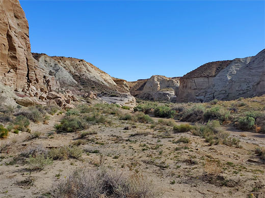
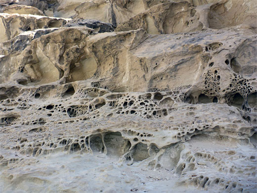
Smoky Mountain Road departs from Big Water along US 89 and is paved at the start, down to the crossing of Wahweap Creek, and for a short distance further, then wide, smooth gravel. The trailhead parking area, with NPS noticeboard, is reached after just less than 5 miles. A constructed path descends via some steps, curves across a bench then leads down to the streambed, of what is the west fork of the canyon. The route passes a small dryfall then climbs back to the plateau to avoid a larger fall - a two-stage drop, often with a residual green pool at the base - after which it winds back down to the canyon floor, just opposite a fine wall of tafoni.
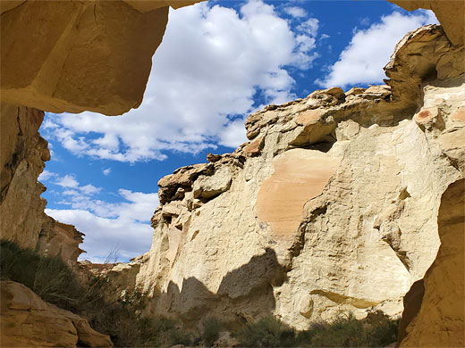
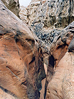
After another few minutes walking along the shallow, cliff-lined ravine, the natural bridge comes in to view - formed where the occasional floodwaters have broken through a narrow fin separating the west fork from the main branch of the canyon, the original confluence point being 600 feet downstream. The main fork can be followed upstream a short distance to a shallow slot section which ends with a dryfall, perhaps with a pile of tumbleweed at the base. The main fork is much shallower above.
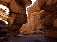
Continuing down the drainage, below the west-main confluence the passageways become rather wide and less photogenic. A very short slot joints from the west then after the same distance again is the junction with the East Fork, approximately similar in size to the main drainage. Walking north up here, a minor tributary joins from the east, with a possible climb-out route opposite. Soon after are a few shallow pools, from a seep, after which the canyon gradually narrows, eventually to a good slot; this rounds a bend and narrows further, to a dark, V-shaped ravine that soon gains height via a series of sloping dryfalls, which can be ascended by stemming, aided by ledges in the walls. Above is a slightly wider section, leading to the initial fall. The exit route from here is up a holey rock face, on the west side, and then a sloping bench and finally a bolder-covered slope, to the canyon rim and the flat land above, returning to the trailhead via cross-country walk of one mile, veering north a way to avoid a deepish part of the main fork..
One possible hike along Wiregrass Canyon is the walk all the way downstream from the road to the lake; this is 4.5 miles, or at least that is to where the lake used to be, but the water now is another mile further. The more interesting section though is just the first mile, since here the canyon forms some attractive narrow passageways, containing a few dryfalls, and also a small natural bridge, at the junction of two forks of the canyon. Not far below this, the drainage opens out somewhat, and there is less to see.
One option for a longer hike is to continue downstream for 0.7 miles, to the junction with another fork of the canyon, on the east side, and return up here; this also has some narrow passageways, leading to a short section of quite a deep slot canyon which can be upclimbed, back to the flat land above. The hike is completed via a cross-country walk to make a loop of 3.2 miles. The climb of the slot, although short, is quite strenuous, however.
Rocks along Wiregrass Canyon are generally dull in color - whitish, grey or light brown, so not particularly pretty. They are composed of four different strata; Dakota Formation around the trailhead, a narrow band of the Morrison Formation in the upper section of the canyon, then Romana Sandstone around the natural bridge and the East Fork slot, and Entrada Sandstone for the remainder of the canyon, all the way to the lake.
Wiregrass Canyon Video
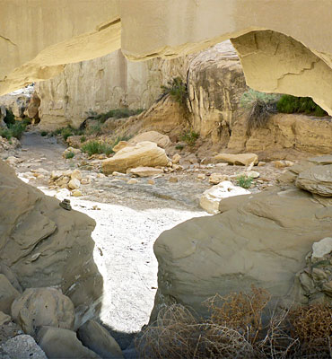
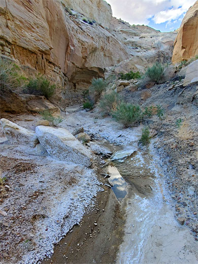
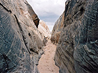
Wiregrass Canyon Trailhead
Smoky Mountain Road departs from Big Water along US 89 and is paved at the start, down to the crossing of Wahweap Creek, and for a short distance further, then wide, smooth gravel. The trailhead parking area, with NPS noticeboard, is reached after just less than 5 miles. A constructed path descends via some steps, curves across a bench then leads down to the streambed, of what is the west fork of the canyon. The route passes a small dryfall then climbs back to the plateau to avoid a larger fall - a two-stage drop, often with a residual green pool at the base - after which it winds back down to the canyon floor, just opposite a fine wall of tafoni.
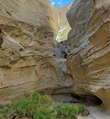
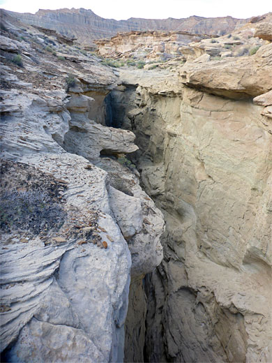
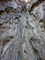
Wiregrass Natural Bridge
After another few minutes walking along the shallow, cliff-lined ravine, the natural bridge comes in to view - formed where the occasional floodwaters have broken through a narrow fin separating the west fork from the main branch of the canyon, the original confluence point being 600 feet downstream. The main fork can be followed upstream a short distance to a shallow slot section which ends with a dryfall, perhaps with a pile of tumbleweed at the base. The main fork is much shallower above.
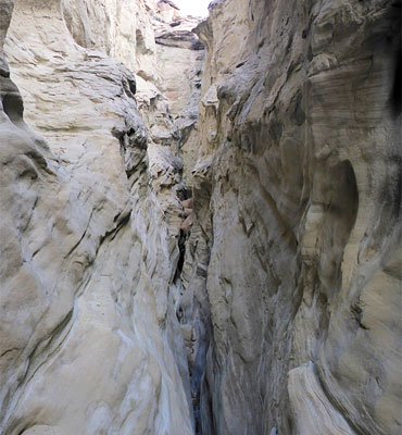
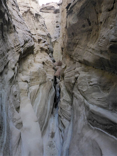
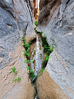
The East Fork Slot
Continuing down the drainage, below the west-main confluence the passageways become rather wide and less photogenic. A very short slot joints from the west then after the same distance again is the junction with the East Fork, approximately similar in size to the main drainage. Walking north up here, a minor tributary joins from the east, with a possible climb-out route opposite. Soon after are a few shallow pools, from a seep, after which the canyon gradually narrows, eventually to a good slot; this rounds a bend and narrows further, to a dark, V-shaped ravine that soon gains height via a series of sloping dryfalls, which can be ascended by stemming, aided by ledges in the walls. Above is a slightly wider section, leading to the initial fall. The exit route from here is up a holey rock face, on the west side, and then a sloping bench and finally a bolder-covered slope, to the canyon rim and the flat land above, returning to the trailhead via cross-country walk of one mile, veering north a way to avoid a deepish part of the main fork..
Topographic Map of Wiregrass Canyon
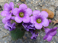
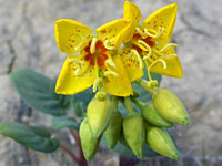
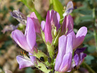
Wiregrass Canyon Wildflowers
More flowers in the canyon
 Beautiful phacelia |
 Paiute suncup |
 Freckled milkvetch |
 Cisco woodyaster |
More flowers in the canyon
Wiregrass Canyon - Similar Hikes
All Contents © Copyright The American Southwest | Comments and Questions | Contribute | Affiliate Marketing Disclosure | Site Map