Trail Point Trail
Path to the top of Boulder Mountain; a gentle climb up sparsely forested slopes, past Divide Lake, followed by a steeper ascent to a viewpoint at the edge of the summit plateau, covered by basalt boulders. The route continues through trees and meadows to the more scenic Circle Lake
Length: 4 miles, to Circle Lake
Elevation change: 1,700 feet
Difficulty: Moderate; one steep section
Type: One way
Usage: Low
Season: Spring, summer, fall
Trailhead: FR 165, Kings Pasture Reservoir
Rating (1-5): ★★★★★
Elevation change: 1,700 feet
Difficulty: Moderate; one steep section
Type: One way
Usage: Low
Season: Spring, summer, fall
Trailhead: FR 165, Kings Pasture Reservoir
Rating (1-5): ★★★★★

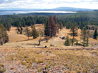
Boulder Mountain, part of the Aquarius Plateau, is an extensive area of flat, elevated, volcanic land, up to 12 miles across - the highest timbered plateau in the US - peaking at 11,317 foot Bluebell Knoll. Woodland flanks the eastern portion while the center and west are mostly treeless, covered instead by grassy prairie, dotted with numerous streams and small lakes. The plateau is edged by steep slopes, with a largely straight escarpment on the west side and more undulating cliffs in other directions, and it is most easily accessed from the east, via trails and tracks starting along Hwy 12, though vehicular access is also possible on longer tracks from the north. Almost all of the mountain is within the Dixie National Forest.
Fishing is the main recreation activity on Boulder Mountain. Hiking is much less popular since the summit is so large, and relatively featureless, and most points along the rim, where the views are better, are not easily accessible. The slopes below the plateau generally lack much of interest, a mix of thick forest and small meadows, and nearly all the land is grazed by cattle, but there are still some good trails, all very lightly used, leading up to the plateau and to the nearby lakes, either just below the rim, where the trees tend to be a bit less dense, or on top, near the edge of the high ground.
One such route is the Trail Point Trail, which climbs gently through aspen woodland, past Divide Lake, followed by a steeper ascent to a viewpoint at the edge of the plateau, where the ground is formed of basalt boulders. The route continues through trees and meadows to the more scenic Circle Lake, where it divides, both branches leading to other lakes. The round-trip to Circle Lake is 8 miles in length taking four hours or more, and is generally easy apart from the steep climb to the plateau, where the path rises 700 feet over less than half a mile. Meadows on the plateau are noted for their wildflowers, with several endemic species found here such as Aquarius Plateau paintbrush and Boulder Mountain cinquefoil.
19 views along the Trail Point Trail.
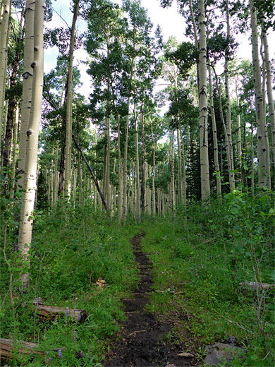
The Trail Point Trail starts near Kings Pasture Reservoir, a small artificial lake along the upper reaches of East Fork Boulder Creek, reached by a 5.7 mile drive along unpaved road FR165, which meets Hwy 12, five miles north of Boulder town. The first section of the track is quite smooth, up to a junction (with FR166), after which it gradually becomes steeper and bumpier but is still normally fine for most vehicles including small RVs, at least during dry times of the year. Near the end is another junction, with a lesser track, soon after which FR165 is blocked by gate, at the edge of the private land surrounding the reservoir. There is parking space for a dozen or so vehicles just before. The trailhead for the hike is 0.6 miles further along the track (which is open for foot traffic) - this descends to edge of the reservoir, crosses the earthen dam, leads across a field and through woodland to a second gate, where it re-enters the national forest. The trail begins on the far side of the gate and is signed Divide Lake, 1 mile.
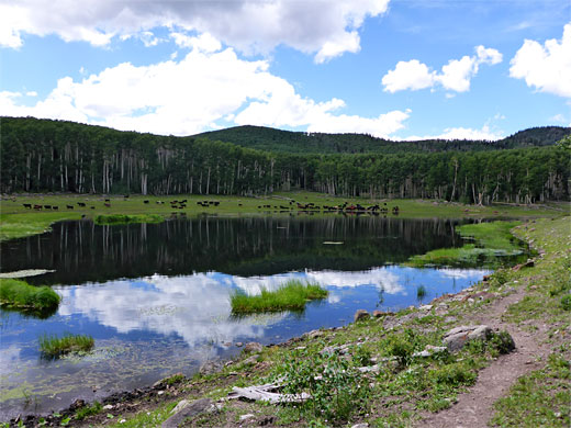
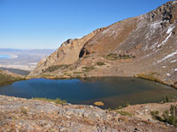
The path heads north through light aspen woods and into a long meadow in a shallow valley centered on a tiny stream; ascending gradually past many dead, fallen trees. The gradient increases a little then lessens towards the head of the valley, as the trail passes over a minor divide and emerges from a belt of trees to the grassy basin containing Divide Lake, a popular watering hole for the many cattle that roam the surrounding slopes. Water smartweed grows at the edge of the water, and the banks harbor a few yellow monkey flowers, but otherwise the surroundings are rather barren. The lake is the final destination for nearly all of the few people who hike the trail, which ahead becomes much fainter. A post on the far side of the lake marks a junction; the East Boulder Creek Trail continues north while the Trail Point Trail forks west, soon moving back to wooded land, where the trees are larger and more closely spaced. The narrow path veers back north and leaves the trees for a sheltered meadow, with a minor seasonal pond near its center. At an indistinct cairn, close to the pond, the trail changes direction again, heading west, though is barely evident until it re-enters the forest. The ground is now more overgrown, and the woodland moister, still with only limited wildflowers.
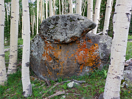
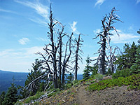
The trail climbs steadily up the slopes, becoming level for a while then rising again as it approaches an area of jumbled basalt boulders at the base of the plateau. The next half mile is much steeper, ascending via switchbacks or directly up the slope, and eventually arriving on the plateau rim, where the woodland is abruptly replaced by piles of boulders, and the views open out. There are still a few trees to block the panorama; the best perspective is about 800 feet away, at the southern tip of a protruding section of the plateau; this is the actual Trail Point, overlooking a vast area of land, towards the upper canyons of the Escalante. One closer feature of interest is a spectacular (seasonal) waterfall 1.8 miles northwest, formed by the West Fork of Boulder Creek as it flows down from the plateau through a narrow gorge, a location not reachable by trail.
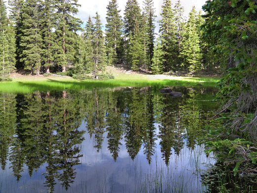
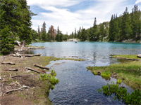
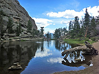
The hiking route, now the Trail Point - Spectacle Lake Trail, continues northwards, and although marked by many closely-spaced cairns, is difficult to follow since the ground is entirely covered by the boulders, with no recognizable sign of a path. The trail soon moves away from the rim, and sparse woodland resumes; the boulders become smaller, and earthen patches appear, where the path is visible once more, though still not easy to follow until it exits the forest and crosses a large dry meadow, with many wildflowers in summer, including the Aquarius Plateau paintbrush. On the far side of the grassland, the path leads down a wooded slope then runs alongside a patch of marshy grassland, through some dry woods and out to a pretty, reed-lined pond at the southern edge of Circle Lake, one of over a dozen similar-looking lakes on this part of the summit plateau. Around the lakes are a different selection of wildflowers to the drier meadows, including american bistort, diamond-leaf pseudosaxifrage and parry's lousewort. In summer all the riparian areas are heavily infested with mosquitoes. The path divides near the pond; the left branch is signed to Crescent Lake and the right to Halfmoon Lake. The two paths lead respectively to Spectacle Lake (2.5 miles) and Horseshoe Lake (1.5 miles), where they meet with 4WD tracks. In summary, the Trail Point Trail is interesting only towards the end, once on the plateau, since the lower section, up to Divide Lake, is spoiled by the cattle, while the middle forest is unremarkable.
Fishing is the main recreation activity on Boulder Mountain. Hiking is much less popular since the summit is so large, and relatively featureless, and most points along the rim, where the views are better, are not easily accessible. The slopes below the plateau generally lack much of interest, a mix of thick forest and small meadows, and nearly all the land is grazed by cattle, but there are still some good trails, all very lightly used, leading up to the plateau and to the nearby lakes, either just below the rim, where the trees tend to be a bit less dense, or on top, near the edge of the high ground.
One such route is the Trail Point Trail, which climbs gently through aspen woodland, past Divide Lake, followed by a steeper ascent to a viewpoint at the edge of the plateau, where the ground is formed of basalt boulders. The route continues through trees and meadows to the more scenic Circle Lake, where it divides, both branches leading to other lakes. The round-trip to Circle Lake is 8 miles in length taking four hours or more, and is generally easy apart from the steep climb to the plateau, where the path rises 700 feet over less than half a mile. Meadows on the plateau are noted for their wildflowers, with several endemic species found here such as Aquarius Plateau paintbrush and Boulder Mountain cinquefoil.
Photographs
19 views along the Trail Point Trail.
Trail Point Trailhead
The Trail Point Trail starts near Kings Pasture Reservoir, a small artificial lake along the upper reaches of East Fork Boulder Creek, reached by a 5.7 mile drive along unpaved road FR165, which meets Hwy 12, five miles north of Boulder town. The first section of the track is quite smooth, up to a junction (with FR166), after which it gradually becomes steeper and bumpier but is still normally fine for most vehicles including small RVs, at least during dry times of the year. Near the end is another junction, with a lesser track, soon after which FR165 is blocked by gate, at the edge of the private land surrounding the reservoir. There is parking space for a dozen or so vehicles just before. The trailhead for the hike is 0.6 miles further along the track (which is open for foot traffic) - this descends to edge of the reservoir, crosses the earthen dam, leads across a field and through woodland to a second gate, where it re-enters the national forest. The trail begins on the far side of the gate and is signed Divide Lake, 1 mile.
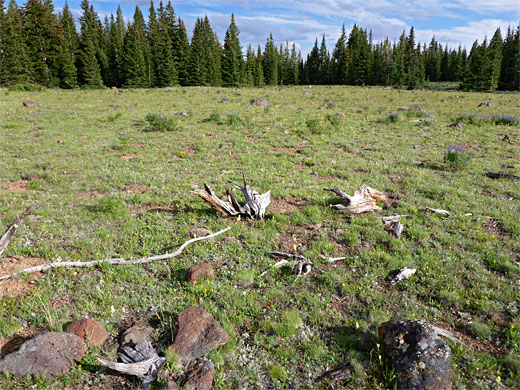
Divide Lake
The path heads north through light aspen woods and into a long meadow in a shallow valley centered on a tiny stream; ascending gradually past many dead, fallen trees. The gradient increases a little then lessens towards the head of the valley, as the trail passes over a minor divide and emerges from a belt of trees to the grassy basin containing Divide Lake, a popular watering hole for the many cattle that roam the surrounding slopes. Water smartweed grows at the edge of the water, and the banks harbor a few yellow monkey flowers, but otherwise the surroundings are rather barren. The lake is the final destination for nearly all of the few people who hike the trail, which ahead becomes much fainter. A post on the far side of the lake marks a junction; the East Boulder Creek Trail continues north while the Trail Point Trail forks west, soon moving back to wooded land, where the trees are larger and more closely spaced. The narrow path veers back north and leaves the trees for a sheltered meadow, with a minor seasonal pond near its center. At an indistinct cairn, close to the pond, the trail changes direction again, heading west, though is barely evident until it re-enters the forest. The ground is now more overgrown, and the woodland moister, still with only limited wildflowers.
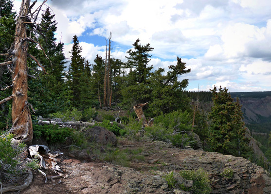
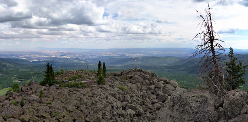
Path to the Rim
The trail climbs steadily up the slopes, becoming level for a while then rising again as it approaches an area of jumbled basalt boulders at the base of the plateau. The next half mile is much steeper, ascending via switchbacks or directly up the slope, and eventually arriving on the plateau rim, where the woodland is abruptly replaced by piles of boulders, and the views open out. There are still a few trees to block the panorama; the best perspective is about 800 feet away, at the southern tip of a protruding section of the plateau; this is the actual Trail Point, overlooking a vast area of land, towards the upper canyons of the Escalante. One closer feature of interest is a spectacular (seasonal) waterfall 1.8 miles northwest, formed by the West Fork of Boulder Creek as it flows down from the plateau through a narrow gorge, a location not reachable by trail.
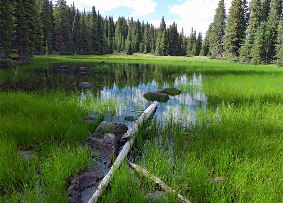
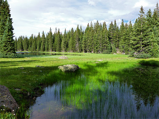
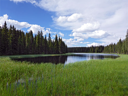
Circle Lake
The hiking route, now the Trail Point - Spectacle Lake Trail, continues northwards, and although marked by many closely-spaced cairns, is difficult to follow since the ground is entirely covered by the boulders, with no recognizable sign of a path. The trail soon moves away from the rim, and sparse woodland resumes; the boulders become smaller, and earthen patches appear, where the path is visible once more, though still not easy to follow until it exits the forest and crosses a large dry meadow, with many wildflowers in summer, including the Aquarius Plateau paintbrush. On the far side of the grassland, the path leads down a wooded slope then runs alongside a patch of marshy grassland, through some dry woods and out to a pretty, reed-lined pond at the southern edge of Circle Lake, one of over a dozen similar-looking lakes on this part of the summit plateau. Around the lakes are a different selection of wildflowers to the drier meadows, including american bistort, diamond-leaf pseudosaxifrage and parry's lousewort. In summer all the riparian areas are heavily infested with mosquitoes. The path divides near the pond; the left branch is signed to Crescent Lake and the right to Halfmoon Lake. The two paths lead respectively to Spectacle Lake (2.5 miles) and Horseshoe Lake (1.5 miles), where they meet with 4WD tracks. In summary, the Trail Point Trail is interesting only towards the end, once on the plateau, since the lower section, up to Divide Lake, is spoiled by the cattle, while the middle forest is unremarkable.
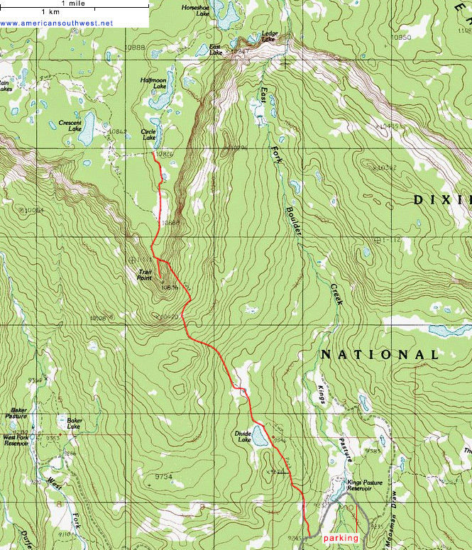
Topographic Map of the Trail Point Trail
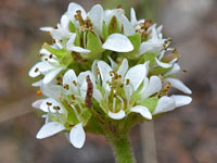
Trail Point Wildflowers
More flowers along the trail
 Diamondleaf pseudosaxifrage |
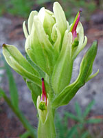 Aquarius paintbrush |
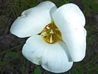 Sego lily |
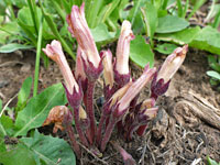 Clustered broomrape |
More flowers along the trail
Trail Point Trail - Similar Hikes
All Contents © Copyright The American Southwest | Comments and Questions | Contribute | Affiliate Marketing Disclosure | Site Map