Gem Lake and Balanced Rock, Rocky Mountain National Park
Colorado > Rocky Mountain National Park > Trails in the East > Gem Lake and Balanced Rock

Gem Lake and Balanced Rock
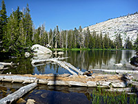
Gem is a small lake, attractively lined by granite cliffs, at the edge of Lumpy Ridge a few miles north of Estes Park, reached by a short trail. Continuation paths head further along the ridge, one to Balanced Rock and similar eroded formations, the other to meadows around Cow Creek, filled with abundant summer wildflowers
Length: 1.6 miles to Gem Lake; 3.8 miles to Balanced Rock or 4.6 miles to Cow Creek. 10 miles partial loop to all three
Elevation change: 1,100 feet to Gem Lake; other paths descend a little
Difficulty: Easy to moderate
Type: One way, or partial off-trail loop
Usage: High to the lake, low thereafter
Season: Spring, summer, fall
Trailhead: Lumpy Ridge, off Devils Gulch Road
Rating (1-5): ★★★★★
Elevation change: 1,100 feet to Gem Lake; other paths descend a little
Difficulty: Easy to moderate
Type: One way, or partial off-trail loop
Usage: High to the lake, low thereafter
Season: Spring, summer, fall
Trailhead: Lumpy Ridge, off Devils Gulch Road
Rating (1-5): ★★★★★

Lumpy Ridge is a mostly wooded line of granite hills on the north side of Estes Park, right by the east edge of Rocky Mountain National Park. The highest point is a relatively low summit of 10,068 feet, below the timberline, yet despite the scenery being generally less spectacular than the higher elevation regions of the park to the west, the trailhead at the base of the ridge is very popular, owing to the proximity to town, the year round access, and perhaps because it can be reached without payment; fees are only collected when entering the park along US 34 or US 36.
The main destination from the Lumpy Ridge trailhead is the small but pretty Gem Lake, reached after a short (1.6 mile) but rather steep hike that gains over 1,000 feet and gives some good views of Estes Park along the way, even though most of the surroundings are quite thickly wooded. Far fewer people continue beyond the lake, as the path descends to a junction, from where the right branch traverses slopes on the north side of the ridge to an intersection with the Cow Creek Trail, passing small streams and grassy meadows, ideal habitat for summer wildflowers.
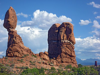
The other branch heads back south towards the top of the ridge to Balanced Rock, a distinctive granite formation, surrounded by other shapely outcrops. This path ends at the rock, but walking cross country eastwards rejoins the initial trail a little way south of Gem Lake to form a loop, saving 2 miles compared with returning along with the official route.
Rocky Mountain National Park map, Gem Lake and Balanced Rock topographic map
17 views along the trail
The Lumpy Ridge trailhead is situated at the end of a short spur off Devils Gulch Road, 1.5 miles north of US 34 in Estes Park. Despite its large size, containing spaces for nearly 100 vehicles, the place often fills up on a busy summer's day. Two paths start here; one to Gem Lake and beyond, around the east side of the ridge, the other (Black Canyon Trail) to the west. An intersecting path on the north side of the ridge allows for a long loop of 10 miles, perhaps staying for a night at one of two backcountry campsites along the way. Another link path near the start forms a much shorter loop of 1.5 miles, running along the base of a pair of granite summits named Twin Owls.
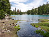
But Gem Lake is the main destination, and the route here begins by following a ravine northwards, climbing fairly steeply up to the junction with the connecting route past the Twin Owls. The surroundings now are a mix of light pine/aspen woodland and open patches, with a floor of coarse granitic sand and rounded boulders. Gaps in the trees allow views of vertical cliffs topped by rocky summits, which rise high above to the west, while occasional promontories to the east provide good vantage points overlooking Lake Estes and the eastern part of Estes Park. The undergrowth becomes a little denser as the trail enters another, cooler ravine, climbing by a few short, steep switchbacks and steps made of granite blocks. The trail ascends above the ravine, veers east and comes out to the shore of Gem Lake, which is bordered by low, vertical, layered cliffs on one side, and a gravel beach on the other. A sign just past the north end of the lake gives distances as Lumpy Ridge trailhead 1.8 miles, Balanced Rock 2.1 miles.
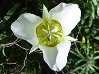
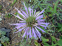
Just beyond Gem Lake is a low saddle (elevation 8,860 feet), after which the trail is briefly level then starts to go down, curving round a wide bend and heading west, still through pine woodland, to a junction with the path to Balanced Rock. The Gem Lake Trail continues north, still fairly flat for while until a steepish descent, when lands to the north first come properly into view - Cow Creek valley and the undulating hills beyond. The path levels out, now leading westwards through patches of trees mingled with meadows and small creeks, most dry by summer. One drainage that flows year-round is crossed by a narrow wooden bridge, shortly before the larger Cow Creek, where the path ends at a junction with the Cow Creek Trail. This lightly-traveled route begins 1.3 miles east along the unpaved McGraw Ranch Road and ends 1.7 miles west at Bridal Veil Falls, after another junction (with the Dark Mountain Trail) that links with the westerly of the two paths from the Lumpy Ridge trailhead. All around the first junction and the last half mile or so of the Gem Lake Trail are many wildflowers, representing at least 40 different species.
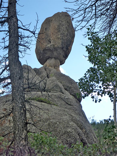
The one mile Balanced Rock Trail starts with a gentle descent, followed by a slightly longer but still not too steep ascent, passing several other balanced rocks on the way to its end point at the base of the main one, located on the east side of a valley; the land falls away by several hundred feet to the west. The rounded granite formation is best visited in the morning, as the easiest viewable face is in shadow in the afternoon, with the sun directly beyond. The top of the rock is about 30 feet above the path and all is enclosed by tall trees so the views are quite limited, and if truth be told the formation is not really that special. The location is 3.9 miles from the Lumpy Ridge trailhead, but this can be reached in only 2 miles by walking due east, through woodland over a wide ridge, passing several small granite summits and descending into a ravine. Following this downstream intersects the Gem Lake Trail about a quarter mile south of the lake. The cross-country route is not always obvious, however, and some places have thick undergrowth.
The main destination from the Lumpy Ridge trailhead is the small but pretty Gem Lake, reached after a short (1.6 mile) but rather steep hike that gains over 1,000 feet and gives some good views of Estes Park along the way, even though most of the surroundings are quite thickly wooded. Far fewer people continue beyond the lake, as the path descends to a junction, from where the right branch traverses slopes on the north side of the ridge to an intersection with the Cow Creek Trail, passing small streams and grassy meadows, ideal habitat for summer wildflowers.
The other branch heads back south towards the top of the ridge to Balanced Rock, a distinctive granite formation, surrounded by other shapely outcrops. This path ends at the rock, but walking cross country eastwards rejoins the initial trail a little way south of Gem Lake to form a loop, saving 2 miles compared with returning along with the official route.
Maps
Rocky Mountain National Park map, Gem Lake and Balanced Rock topographic map
Photographs
17 views along the trail
Trailhead for Gem Lake
The Lumpy Ridge trailhead is situated at the end of a short spur off Devils Gulch Road, 1.5 miles north of US 34 in Estes Park. Despite its large size, containing spaces for nearly 100 vehicles, the place often fills up on a busy summer's day. Two paths start here; one to Gem Lake and beyond, around the east side of the ridge, the other (Black Canyon Trail) to the west. An intersecting path on the north side of the ridge allows for a long loop of 10 miles, perhaps staying for a night at one of two backcountry campsites along the way. Another link path near the start forms a much shorter loop of 1.5 miles, running along the base of a pair of granite summits named Twin Owls.
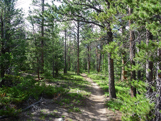
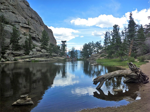
Gem Lake
But Gem Lake is the main destination, and the route here begins by following a ravine northwards, climbing fairly steeply up to the junction with the connecting route past the Twin Owls. The surroundings now are a mix of light pine/aspen woodland and open patches, with a floor of coarse granitic sand and rounded boulders. Gaps in the trees allow views of vertical cliffs topped by rocky summits, which rise high above to the west, while occasional promontories to the east provide good vantage points overlooking Lake Estes and the eastern part of Estes Park. The undergrowth becomes a little denser as the trail enters another, cooler ravine, climbing by a few short, steep switchbacks and steps made of granite blocks. The trail ascends above the ravine, veers east and comes out to the shore of Gem Lake, which is bordered by low, vertical, layered cliffs on one side, and a gravel beach on the other. A sign just past the north end of the lake gives distances as Lumpy Ridge trailhead 1.8 miles, Balanced Rock 2.1 miles.
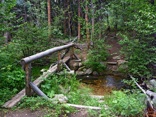
Cow Creek
Just beyond Gem Lake is a low saddle (elevation 8,860 feet), after which the trail is briefly level then starts to go down, curving round a wide bend and heading west, still through pine woodland, to a junction with the path to Balanced Rock. The Gem Lake Trail continues north, still fairly flat for while until a steepish descent, when lands to the north first come properly into view - Cow Creek valley and the undulating hills beyond. The path levels out, now leading westwards through patches of trees mingled with meadows and small creeks, most dry by summer. One drainage that flows year-round is crossed by a narrow wooden bridge, shortly before the larger Cow Creek, where the path ends at a junction with the Cow Creek Trail. This lightly-traveled route begins 1.3 miles east along the unpaved McGraw Ranch Road and ends 1.7 miles west at Bridal Veil Falls, after another junction (with the Dark Mountain Trail) that links with the westerly of the two paths from the Lumpy Ridge trailhead. All around the first junction and the last half mile or so of the Gem Lake Trail are many wildflowers, representing at least 40 different species.

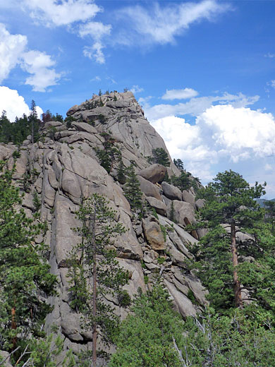
Balanced Rock
The one mile Balanced Rock Trail starts with a gentle descent, followed by a slightly longer but still not too steep ascent, passing several other balanced rocks on the way to its end point at the base of the main one, located on the east side of a valley; the land falls away by several hundred feet to the west. The rounded granite formation is best visited in the morning, as the easiest viewable face is in shadow in the afternoon, with the sun directly beyond. The top of the rock is about 30 feet above the path and all is enclosed by tall trees so the views are quite limited, and if truth be told the formation is not really that special. The location is 3.9 miles from the Lumpy Ridge trailhead, but this can be reached in only 2 miles by walking due east, through woodland over a wide ridge, passing several small granite summits and descending into a ravine. Following this downstream intersects the Gem Lake Trail about a quarter mile south of the lake. The cross-country route is not always obvious, however, and some places have thick undergrowth.


Gem Lake and Balanced Rock - Similar Hikes
All Contents © Copyright The American Southwest | Comments and Questions | Contribute | Affiliate Marketing Disclosure | Site Map