Timber Lake Trail, Rocky Mountain National Park
Colorado > Rocky Mountain National Park > Trails in the West > Timber Lake
Timber Lake Trail
Moderately steep path across the forested hillside above Timber Creek, up to the source of the stream at a pretty lake beyond the treeline, close to the continental divide. Rocky slopes enclose three sides of the lake, but a short off-trail ascent reaches a minor summit with more expansive views
Length: 4.6 miles to the lake, 5.6 miles to the summit
Elevation change: 2,060 feet, 2,780 feet
Difficulty: Moderate to strenuous
Type: One way
Usage: Low
Season: Late spring, summer, fall
Trailhead: Beside US 34
Rating (1-5): ★★★★★
Elevation change: 2,060 feet, 2,780 feet
Difficulty: Moderate to strenuous
Type: One way
Usage: Low
Season: Late spring, summer, fall
Trailhead: Beside US 34
Rating (1-5): ★★★★★

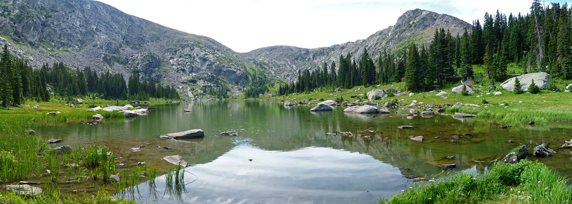
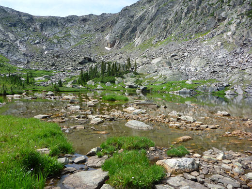
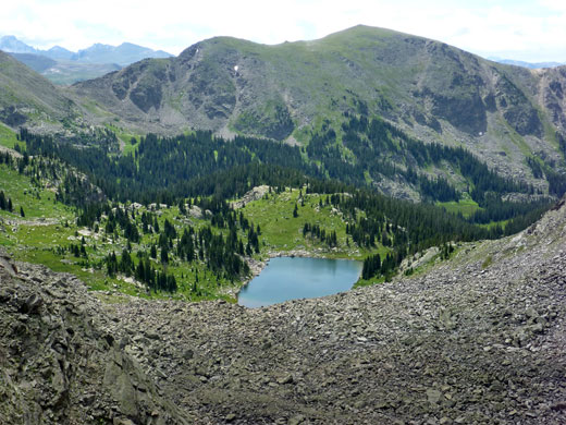
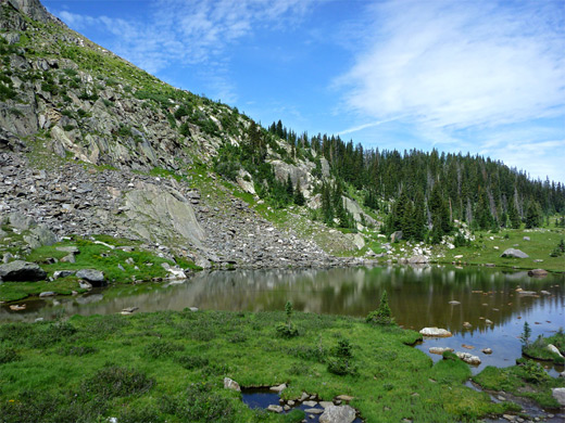
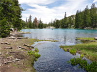
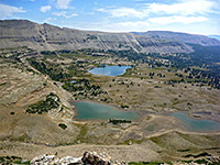
Timber Lake is a typical Rocky Mountain National Park day hike destination, situated on the slightly less busy west side of the mountains and reached by a 4.6 mile path starting from a large trailhead in Kawuneeche Valley, along US 34 just before the start of the steep climb towards Trail Ridge. Like many other paths in the park, most of the hike is through thick pine woods, albeit with occasional views of the valley and the surrounding mountains, but the trees are more dispersed towards the upper reaches, mingling with meadows and open streamways, and the forest stops completely shortly before the lake, which sits at the very upper end of a ravine at 11,060 feet elevation, lined by rocky slopes on three sides.
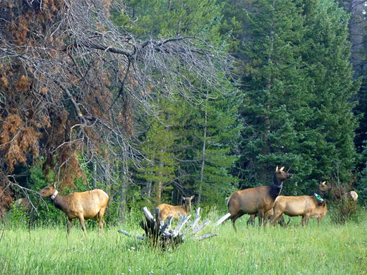
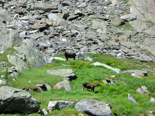
The maintained trail stops here, but it is relatively easy to climb the hillside to the south, up to a saddle above nearby Julian Lake, and on to a flat summit that gives good views of the valley to the west. In the other direction, the land slopes up at a similarly moderate gradient by another 1,000 feet to Mount Ida on the continental divide. The trail is notable for a great number of different wildflower species, reflecting the varied habitats along the way, including streams, dry meadows, boggy meadows, moist and dry forest, lakeshore and tundra. The lake and the meadows are also a renowned wildlife location; elk and moose are frequently spotted, bears less often.
Rocky Mountain National Park map
Timber Lake topographic map
18 views along the trail
The Timber Lake Trail starts from a large parking area, also used by picnickers, beside US 34 right opposite the short side road to the equally large lot at the Colorado River trailhead, for hikes to Lulu City and the upper Colorado River. This location is ten miles from the national park entry station near Grand Lake.
The hike begins by crossing a meadow, often frequented by elk, and entering light, moist woodland, soon descending slightly and crossing the small drainage of Phantom Creek. The forest thickens beyond, as the path curves south, passing a good selection of wildflowers in summer, and staying relatively level, at least until reaching Beaver Creek, a larger stream, beyond which the land is drier and so has fewer flowers. The route steepens, still heading south, traversing the lower slopes of Jackstraw Mountain, and is mostly quite straight. It arrives at a temporarily flat and open area with views of Kawuneeche Valley, and becomes more level beyond, now trending southeast, into the lower end of Timber Creek valley, its deep V-shape visible through gaps in the trees. The path crosses two relatively large tributary streams and many tiny seeps, some home solely to one particular flower species not common elsewhere in this location such as fringed grass of parnassus and Richardson's geranium. A recent landslip has created a minor obstruction, passed by climbing through a pile of boulders. Timber Creek is clearly audible, though remains quite far below for a while, becoming closer near the junction with the Long Meadow Trail (3.7 miles from the start); this crosses the stream and climbs a little to the north end of an extensive area of moist grassland, 1.5 miles in length. Also near here is a spur trail to the Timber Creek backcountry campsite, one of five in the vicinity.
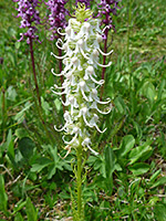
Switchbacks take the main path quickly away from the stream and along the edge of a boggy meadow that contains many distinctive wildflower species such as elegant death camas, pink wintergreen, white bog orchid, Rocky Mountain fringed gentian and elephant heads. More steep climbing follows but the path is soon back at creek level, and enters an elongated, drier meadow, crossed by a few tiny streams. The journey to the lake is completed by one more short climb, up to more grassland at the north end, which also has many flowers; most abundant are the pink/purple elephant heads, including a few of the rare all-white variety.
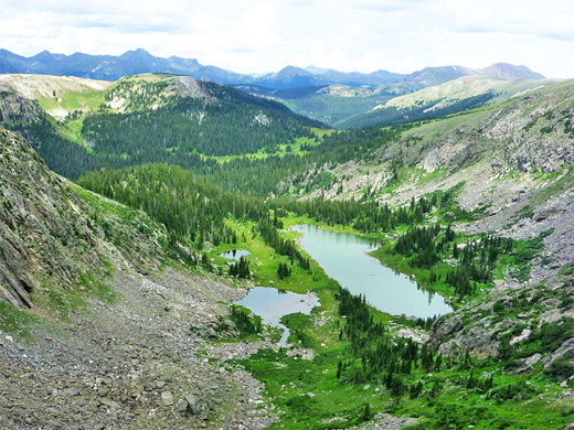
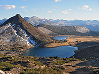
The lake is lined by cliffs of grey, metamorphic rock to the east and a thin belt of trees to the west, beyond which are two small ponds, slightly higher in elevation. Paths follow both sides of the lake, rejoining at the far end and leading towards the base of the slope to the south, which provides a route up to the saddle at the head of the valley. The route is unmarked but easy enough, climbing over a mix of boulders and grass and even more different types of flowers, becoming just boulders towards the top. At the saddle, Julian Lake comes in to view ahead, 640 feet below, and part of Kawuneeche Valley in the distance, but the views of this are much more extensive from the flat-topped summit just to the west, 100 feet higher. The land now is part of the tundra zone, home to several dwarf plant species such as moss campion, Parrys clover and mountain sorrel. A huge area of the park can be seen including many peaks along the continental divide.
The maintained trail stops here, but it is relatively easy to climb the hillside to the south, up to a saddle above nearby Julian Lake, and on to a flat summit that gives good views of the valley to the west. In the other direction, the land slopes up at a similarly moderate gradient by another 1,000 feet to Mount Ida on the continental divide. The trail is notable for a great number of different wildflower species, reflecting the varied habitats along the way, including streams, dry meadows, boggy meadows, moist and dry forest, lakeshore and tundra. The lake and the meadows are also a renowned wildlife location; elk and moose are frequently spotted, bears less often.
Maps
Rocky Mountain National Park map
Timber Lake topographic map
Photographs
18 views along the trail
Trailhead
The Timber Lake Trail starts from a large parking area, also used by picnickers, beside US 34 right opposite the short side road to the equally large lot at the Colorado River trailhead, for hikes to Lulu City and the upper Colorado River. This location is ten miles from the national park entry station near Grand Lake.

The Trail to Timber Creek
The hike begins by crossing a meadow, often frequented by elk, and entering light, moist woodland, soon descending slightly and crossing the small drainage of Phantom Creek. The forest thickens beyond, as the path curves south, passing a good selection of wildflowers in summer, and staying relatively level, at least until reaching Beaver Creek, a larger stream, beyond which the land is drier and so has fewer flowers. The route steepens, still heading south, traversing the lower slopes of Jackstraw Mountain, and is mostly quite straight. It arrives at a temporarily flat and open area with views of Kawuneeche Valley, and becomes more level beyond, now trending southeast, into the lower end of Timber Creek valley, its deep V-shape visible through gaps in the trees. The path crosses two relatively large tributary streams and many tiny seeps, some home solely to one particular flower species not common elsewhere in this location such as fringed grass of parnassus and Richardson's geranium. A recent landslip has created a minor obstruction, passed by climbing through a pile of boulders. Timber Creek is clearly audible, though remains quite far below for a while, becoming closer near the junction with the Long Meadow Trail (3.7 miles from the start); this crosses the stream and climbs a little to the north end of an extensive area of moist grassland, 1.5 miles in length. Also near here is a spur trail to the Timber Creek backcountry campsite, one of five in the vicinity.
End of the Trail
Switchbacks take the main path quickly away from the stream and along the edge of a boggy meadow that contains many distinctive wildflower species such as elegant death camas, pink wintergreen, white bog orchid, Rocky Mountain fringed gentian and elephant heads. More steep climbing follows but the path is soon back at creek level, and enters an elongated, drier meadow, crossed by a few tiny streams. The journey to the lake is completed by one more short climb, up to more grassland at the north end, which also has many flowers; most abundant are the pink/purple elephant heads, including a few of the rare all-white variety.
Timber Lake
The lake is lined by cliffs of grey, metamorphic rock to the east and a thin belt of trees to the west, beyond which are two small ponds, slightly higher in elevation. Paths follow both sides of the lake, rejoining at the far end and leading towards the base of the slope to the south, which provides a route up to the saddle at the head of the valley. The route is unmarked but easy enough, climbing over a mix of boulders and grass and even more different types of flowers, becoming just boulders towards the top. At the saddle, Julian Lake comes in to view ahead, 640 feet below, and part of Kawuneeche Valley in the distance, but the views of this are much more extensive from the flat-topped summit just to the west, 100 feet higher. The land now is part of the tundra zone, home to several dwarf plant species such as moss campion, Parrys clover and mountain sorrel. A huge area of the park can be seen including many peaks along the continental divide.

Timber Lake Trail - Similar Hikes
All Contents © Copyright The American Southwest | Comments and Questions | Contribute | Affiliate Marketing Disclosure | Site Map