Powell Point Trail
Short path to a spectacular, high elevation, red and white rock viewpoint on the south side of Escalante Mountain, overlooking a vast area of southern Utah. Reached by a rough, 3.7 mile track through pine woods, an optional hike for some
Length: 0.8 miles
Elevation change: 100 feet
Difficulty: Easy
Type: One way
Usage: Low
Season: Summer, fall
Trailhead: End of a 3.7 mile track off FR132
Rating (1-5): ★★★★★
Elevation change: 100 feet
Difficulty: Easy
Type: One way
Usage: Low
Season: Summer, fall
Trailhead: End of a 3.7 mile track off FR132
Rating (1-5): ★★★★★

Named after the famed explorer John Wesley Powell, Powell Point is the southernmost tip of a narrow promontory projecting from Table Cliff Plateau, the southern section of the Escalante Mountains - a spur off the Aquarius Plateau in the easterly of the four components of the Dixie National Forest. The elevation is 10,180 feet, high enough for the approach road to be closed by snow from fall to late spring, and even in summer access is not straightforward, requiring a drive of 13 miles along an unpaved track, another 3.7 mile drive, or hike, along a lesser track, and a 0.8 mile walk, along the actual Powell Point Trail.
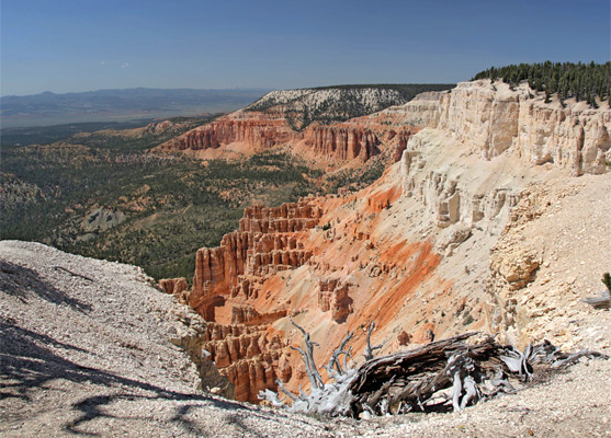
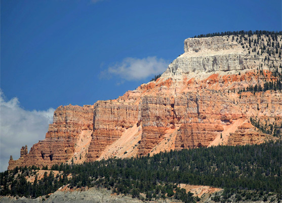
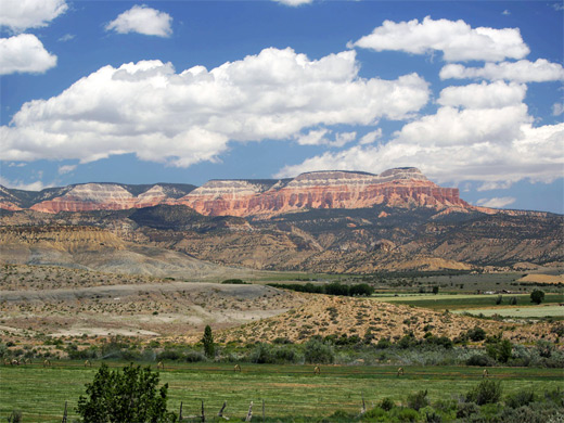
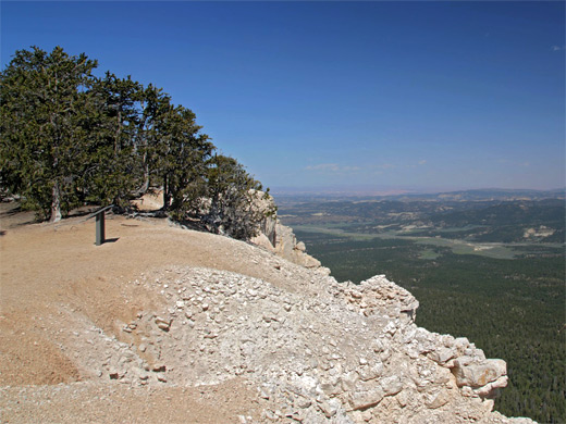
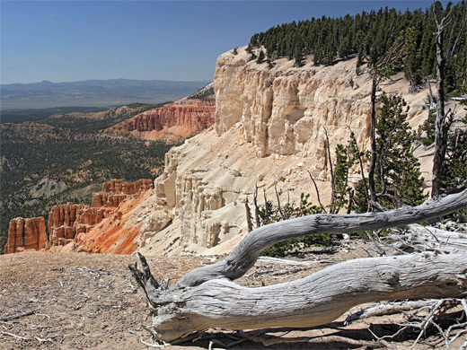
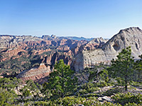
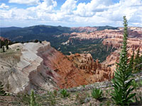
The point overlooks a vast area of southern Utah, nearly all within Grand Staircase-Escalante National Monument, and beyond to Navajo Mountain in Arizona. Rocks at the point are pure white, from the White Member of the Claron Formation, the youngest component of the Grand Staircase, while lower down are cliffs and hoodoos colored rich shades of orange, from the underlying Pink Member of the Claron Formation.
The point may be seen from afar from many locations including Powell Point Vista on Hwy 12 and from East Valley near Tropic, and viewed close up, from below, via the Under the Point Trail, the start of which is reached by a 6 mile drive along a gravel track (FR148), off Hwy 12.
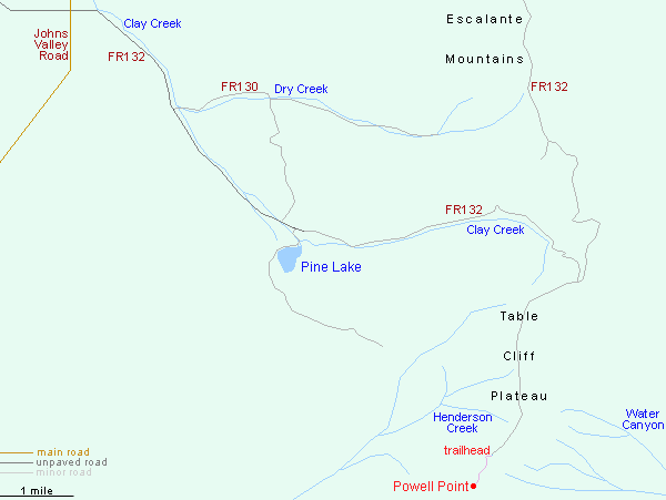
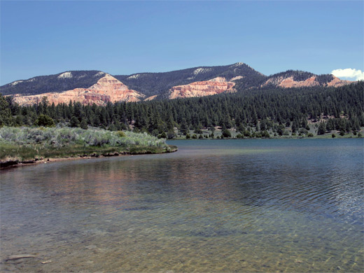
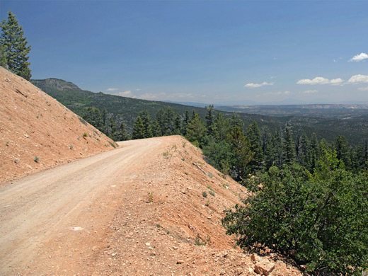
The road to the point, FR132, starts in the west at an intersection with CR1660 (Johns Valley Road), 12 miles north of Bryce Canyon Village, heading southeast for 5.5 miles along the broad valley of Clay Creek to Pine Lake, site of a campground, then following the creek further as it ascends into the mountains, eventually reaching the top of Table Cliff Plateau (10,112 feet) and the junction with the spur road to the point. The surface along FR132 deteriorates over the previous few miles, becoming stony and uneven, though it is generally fine for 2WD vehicles. The access road continues north along the plateau for 9 miles before meeting a wider track (also unpaved) - Hwy 17, which links Johns Valley Road with Hwy 12 near Escalante. The southerly of the two approaches to the point is by far the most popular.
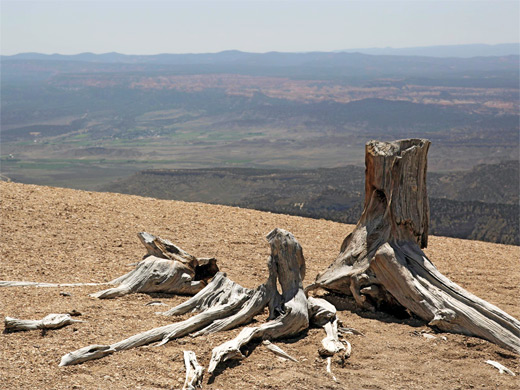
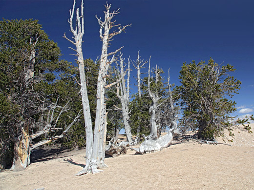
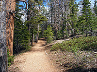
The 3.7 mile side road to the point trailhead runs really all through dense pine forest, almost level, initially with no long-distance views, until it approaches the east edge of the plateau. It passes above two west-side canyons, upper forks of Henderson Creek, and ends at a small parking place, just before the plateau narrows abruptly. The trail follows the top of a slender ridge, first descending about 100 feet then gradually rising again, passing through sparse woodland of bristlecone pines and other trees, to the elongated viewpoint, where the ground falls away very steeply by over 1,000 feet. The terrain at the rim is completely unvegetated, with just occasional ancient trunks of long-dead trees, so there is nothing to obscure the far-reaching views..
The point overlooks a vast area of southern Utah, nearly all within Grand Staircase-Escalante National Monument, and beyond to Navajo Mountain in Arizona. Rocks at the point are pure white, from the White Member of the Claron Formation, the youngest component of the Grand Staircase, while lower down are cliffs and hoodoos colored rich shades of orange, from the underlying Pink Member of the Claron Formation.
The point may be seen from afar from many locations including Powell Point Vista on Hwy 12 and from East Valley near Tropic, and viewed close up, from below, via the Under the Point Trail, the start of which is reached by a 6 mile drive along a gravel track (FR148), off Hwy 12.
Roads to Powell Point
The road to the point, FR132, starts in the west at an intersection with CR1660 (Johns Valley Road), 12 miles north of Bryce Canyon Village, heading southeast for 5.5 miles along the broad valley of Clay Creek to Pine Lake, site of a campground, then following the creek further as it ascends into the mountains, eventually reaching the top of Table Cliff Plateau (10,112 feet) and the junction with the spur road to the point. The surface along FR132 deteriorates over the previous few miles, becoming stony and uneven, though it is generally fine for 2WD vehicles. The access road continues north along the plateau for 9 miles before meeting a wider track (also unpaved) - Hwy 17, which links Johns Valley Road with Hwy 12 near Escalante. The southerly of the two approaches to the point is by far the most popular.
The Trail
The 3.7 mile side road to the point trailhead runs really all through dense pine forest, almost level, initially with no long-distance views, until it approaches the east edge of the plateau. It passes above two west-side canyons, upper forks of Henderson Creek, and ends at a small parking place, just before the plateau narrows abruptly. The trail follows the top of a slender ridge, first descending about 100 feet then gradually rising again, passing through sparse woodland of bristlecone pines and other trees, to the elongated viewpoint, where the ground falls away very steeply by over 1,000 feet. The terrain at the rim is completely unvegetated, with just occasional ancient trunks of long-dead trees, so there is nothing to obscure the far-reaching views..
Map of the Powell Point Trail
Powell Point Trail - Similar Hikes
All Contents © Copyright The American Southwest | Comments and Questions | Contribute | Affiliate Marketing Disclosure | Site Map