Highlights:
Large area either side of the Rio Grande in central New Mexico; wetlands, woodland and grassland by the river, with arid, desert hills to the west, bisected by the Rio Salado, and to the east. The reserve spans four biomes: Chihuahuan Desert, Great Plains Grasslands, Pinyon-Juniper Woodlands, and Colorado Plateau Shrub-Steppe
Nearby town:
Socorro, 20 miles
Management:
Location:
Seasons:
All year
Rating (1-5):
★★★★★
Weather:


At 230,000 acres, Sevilleta is by some distance the largest of the nine National Nature Reserves in New Mexico, occupying an approximately rectangular-shaped area of land around 30 by 15 miles in extent, either side of the Rio Grande in the center of the State. The terrain is riparian along the river, elevation as low as 4,700 feet, giving way to stony or grassy plains and small hills, rising along the east and west edges to mountains, up to 7,400 feet. The refuge sits at the crossroads of four biomes; Chihuahuan Desert, Great Plains Grasslands, Pinyon-Juniper Woodlands, and Colorado Plateau Shrub-Steppe, and so is home to a good variety of plant and animal life.
In common with many other national nature reserves, Sevilleta is not especially scenic and is not a major attraction. It has a few short trails, plus birdwatching areas in the wetlands; most of the refuge is crossed only by rough tracks, and the majority is completely pathless, and indeed not open to the public, so for a casual visit, two or three hours is enough, to drive to the wetlands and hike one or more of the maintained trails, all of which are in the vicinity of the visitor center, along I-25, which, like the Rio Grande, crosses the middle of the reserve from north to south. The western half of the reserve is itself divided into two portions by the Rio Salado, a smaller watercourse, dry at some times of the year.
In common with many other national nature reserves, Sevilleta is not especially scenic and is not a major attraction. It has a few short trails, plus birdwatching areas in the wetlands; most of the refuge is crossed only by rough tracks, and the majority is completely pathless, and indeed not open to the public, so for a casual visit, two or three hours is enough, to drive to the wetlands and hike one or more of the maintained trails, all of which are in the vicinity of the visitor center, along I-25, which, like the Rio Grande, crosses the middle of the reserve from north to south. The western half of the reserve is itself divided into two portions by the Rio Salado, a smaller watercourse, dry at some times of the year.
Sevilleta Table of Contents
- Map
- Photographs
- Access
- Hiking
- Ladrones Vista and Mesa View Trails
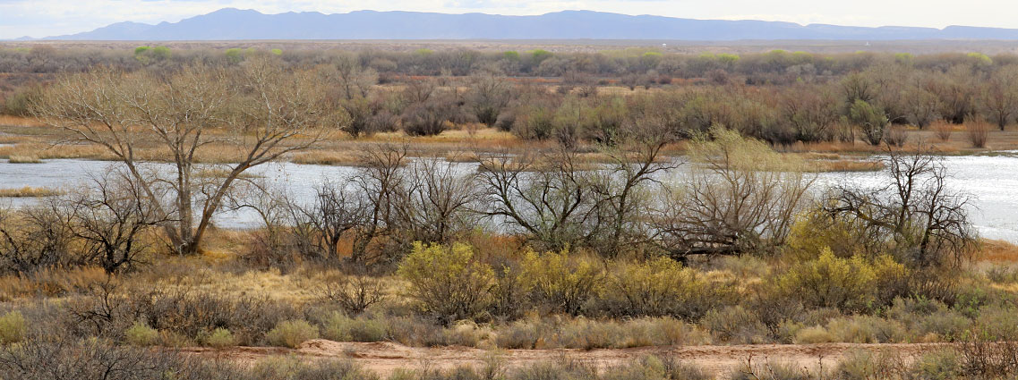
- The wetlands
- Nearby places
- Similar places
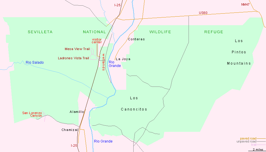
Map of Sevilleta National Wildlife Refuge
Photographs
21 views of Sevilleta National Wildlife Refuge.
Access
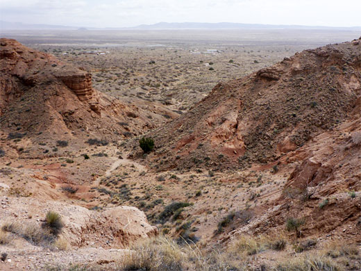
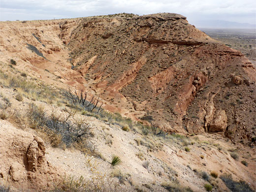
The main public access to Sevilleta National Nature Reserve is I-25 exit 169; to the west, a short road leads the visitor center, from where the short trails depart, while to the east is an unpaved track to the wetlands, close to the Rio Grande, though the river itself is not reachable, being contained within an overgrown corridor of trees, bushes and marsh. The only other section of the NWR with recognized (but unmaintained) trails is towards the southwest corner, at San Lorenzo Canyon, reached by driving 6 miles along a track that follows a dry wash to the point where it becomes enclosed in quite a narrow ravine. 4WD vehicles can continue all through the ravine, and there are several paths across the hills and side canyons to north and south, which are dotted with photogenic rock formations.
Hiking
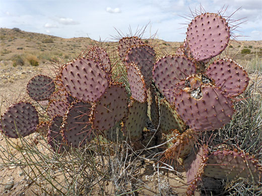
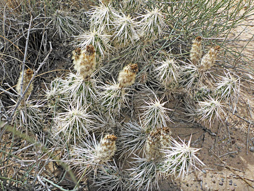
The visitor center, on the west side of I-25, is quite a large place, only open on some days of the week. Maps are available outside. Nearby are some administration buildings, usually with quite a few vehicles in front. The surroundings are bushy, dusty desert, with low hills close by to the west - rather uninspiring scenery. Four trails start here; two are very short, the quarter of a mile Wildflower Loop and the one mile Nature Loop, both over the flat desert, while the other two form a longer, figure-of-eight loop, climbing over the adjacent ridges and slopes. These have a reasonable variety of wildflowers, and several species of cacti including the fearsome-looking devil cholla.
Ladrones Vista and Mesa View Trails
The southern portion of the longer loop, the Ladrones Vista Trail, heads south initially, sharing part of the Nature Loop, then crosses a dry wash and climbs steadily, westwards, up a ridge to the rim of a plateau, where it turns north, running along the edge of a steep slope. To the west is an expanse of flat grassland, marked with 'Area Closed' notices. The path winds through some brownish red hills, past a few big drop-offs to a junction with the other component of the figure-of-eight loop, the Mesa View Trail. Turning right, the path has a quick descent back to the visitor center, en route passing the second Mesa View intersection. This loop, 2 miles, is similar to Ladrones Vista - the upper section follows the plateau rim and the lower part traverses stony flats and hills. Both trails have several benches along the way.
The Wetlands
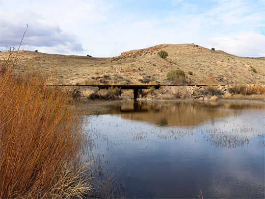
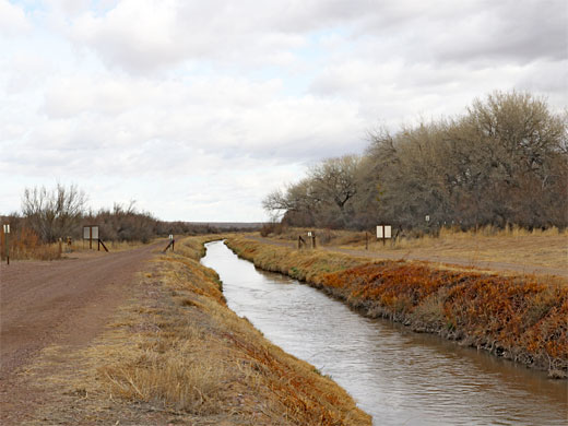
From I-25, the one track into the wetlands turns heads south a way, parallel to the interstate, then turns east for a short distance, up to an embankment, canal and BNSF railway line, where it forks. One branch goes north, past several wildlife viewing places, and the other goes south, soon crossing the railway to a few more access points. Again, for much of year the surroundings are dusty, dry even, and not so interesting as regards scenery. Slightly better is an area closer to the interstate exit; a track/path runs alongside a larger, more permanent area of open water lined by trees, and this seems to be the most likely place to see birds and other wildlife.
Sevilleta - Nearby Places
- Bosque del Apache National Wildlife Refuge (40 miles) - riparian area with desert surroundings, along the Rio Grande
- Salinas Pueblo Missions National Monument (50 miles) - Spanish missions, beside smaller ruins of ancient pueblos
Sevilleta - Similar Places
- Elephant Butte Lake State Park, New Mexico - reservoir along the Rio Grande
- Kofa National Wildlife Refufe, Arizona - isolated mountain ranges and wide cactus plains
All Contents © Copyright The American Southwest | Comments and Questions | Contribute | Affiliate Marketing Disclosure | Site Map