Highlights:
Peaceful, diverse riparian area with desert surroundings, along the Rio Grande - canals, ponds, swamps and flooded woodland, seasonal home to many bird species
Nearby town:
Socorro, 18 miles
Management:
Location:
Seasons:
All year. Greatest numbers of birds are present in the fall
Rating (1-5):
★★★★★
Weather:


Bosque del Apache NWR is part of the New Mexico Highlights itinerary
Featured Hotel
Holiday Inn Express Socorro
 Centrally located hotel along the main road through Socorro, offering free hot breakfast and an outdoor pool; 20 miles from the national wildlife refuge
Check Rates
The Rio Grande is the only significant water source in the arid Chihuahuan Desert lands of central New Mexico, flowing mostly through a wide, flat-floored valley that in some places is prone to flooding, during spring and early summer after snowmelt in the mountains to the north. The floodplain supports vegetation not otherwise present in this part of the state, including cottonwood and willow, which in turn attracts a wide variety of wildlife, and so these riverside areas were a natural home for the native Piro Indians, resident here between 1300 and 1680 AD.
One section of marsh 18 miles south of Socorro has over the last century been artificially irrigated and adapted to create a permanent expanse of ponds, swamps, canals and farmland, managed by the US Fish and Wildlife Service (FWS) as the Bosque del Apache National Wildlife Refuge (established 1939), which is recognized as one of the largest and most important resting grounds for migratory birds in the USA.
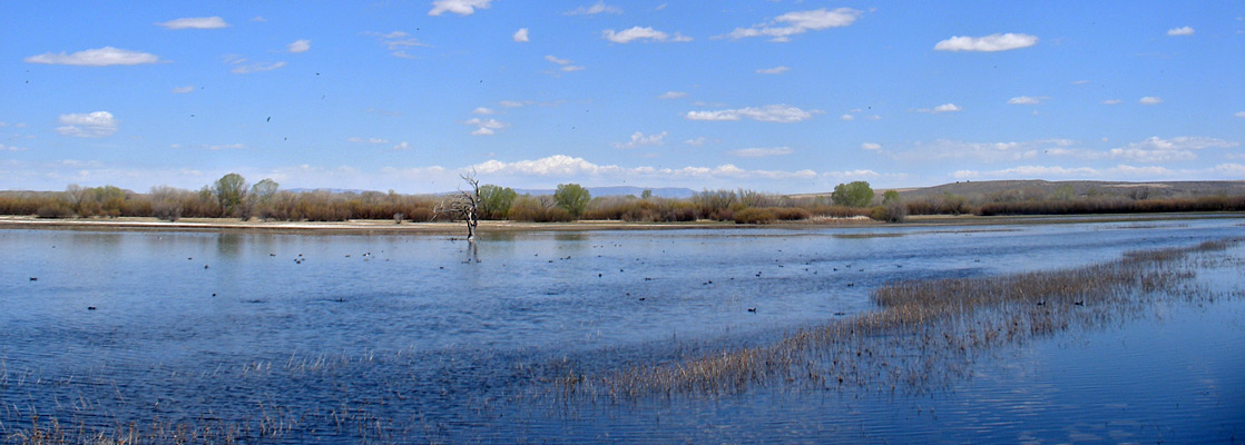
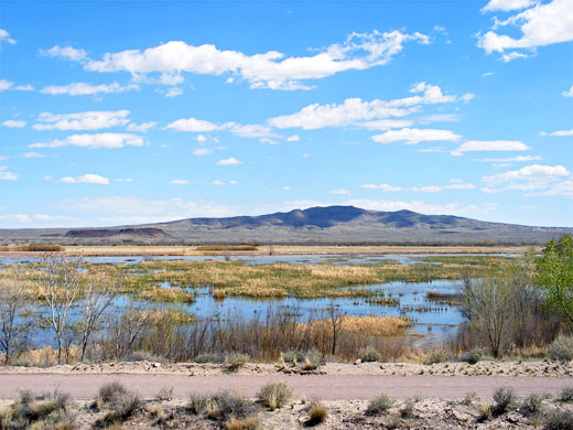
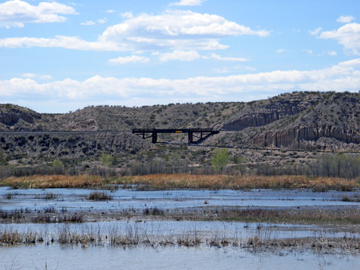
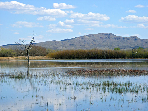
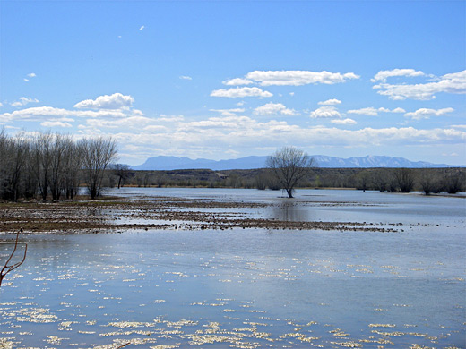
Besides the birds and other wildlife, the refuge is also memorable for the contrast between the peaceful, watery scenery and the dry desert hills at either side; the drainage channels, marshland and flooded forest are more typical of swamps in Florida and the southeast, yet the surroundings are unmistakably southwestern, with rocky, cactus and scrub-covered hills split by branched dry washes.
The refuge is most spectacular during fall, when many thousands of birds arrive, to spend the winter here before departing during spring; the main species are snow geese, Canada geese, sandhill cranes, bald eagles and several types of duck.
One section of marsh 18 miles south of Socorro has over the last century been artificially irrigated and adapted to create a permanent expanse of ponds, swamps, canals and farmland, managed by the US Fish and Wildlife Service (FWS) as the Bosque del Apache National Wildlife Refuge (established 1939), which is recognized as one of the largest and most important resting grounds for migratory birds in the USA.
Besides the birds and other wildlife, the refuge is also memorable for the contrast between the peaceful, watery scenery and the dry desert hills at either side; the drainage channels, marshland and flooded forest are more typical of swamps in Florida and the southeast, yet the surroundings are unmistakably southwestern, with rocky, cactus and scrub-covered hills split by branched dry washes.
The refuge is most spectacular during fall, when many thousands of birds arrive, to spend the winter here before departing during spring; the main species are snow geese, Canada geese, sandhill cranes, bald eagles and several types of duck.
Bosque del Apache Table of Contents
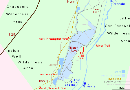
Map of the central section of Bosque del Apache National Wildlife Refuge
Approach and Facilities
Away from the NWR, this region of New Mexico is quite undeveloped, and there are few roads apart from I-25, running parallel to the Rio Grande a few miles to the west. The refuge is accessed via Hwy 1 (Old NM 85), which leaves the interstate near exit 115 and rejoins 27 miles further north (exit 139) at the small town of San Antonio, south of Socorro. The refuge is about half way along, occupying a roughly triangular area of land ten miles in extent. Another entry is from exit 124 of the interstate, via a short unpaved road. Although the primary purposes are wildlife protection, land management and agricultural research, the wildlife refuge is managed like a state park - it has a visitor center, brochure, gift shop, picnic area, arboretum, scenic drive and hiking trails, and charges a fee ($5 in 2024) for entry. There is no campground (yet), but good locations for free camping can be found on the unfenced desert lands to the south.
Sights and Activities in Bosque del Apache NWR
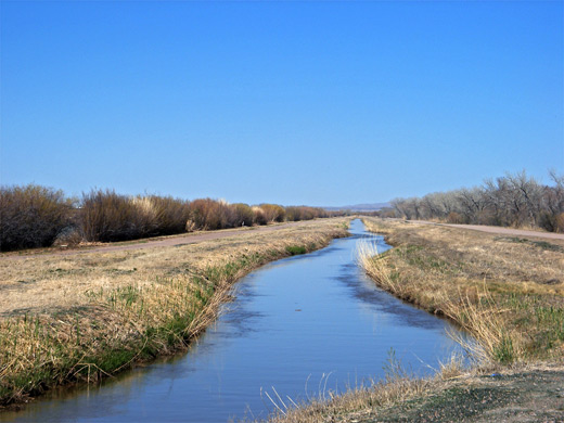
The longer trails in Bosque del Apache National Wildlife Refuge cross the barren hills to the west (designated wilderness areas), so are not especially interesting, encountering similar terrain to any other elevated part of the New Mexico desert. Routes include the 2.5 mile (loop) Canyon Trail in the Indian Well Wilderness Area, and the more strenuous, 5 mile Chupadera Trail across the mountains in the northwest part of the reserve. Instead, most visitors just drive the 12 mile Wildlife Tour road through the refuge, stopping at various overlooks and short paths. The road consists of two linked circuits, the Marsh Loop through wetlands in the south, and the Farm Loop across cultivated terrain in the north; both loops are wide gravel tracks running alongside the straight drainage channels that criss-cross the refuge, and pass many lesser tracks, closed to the public.
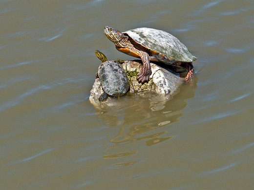
The waters flow generally from north to south, over a few small weirs, and are periodically diverted to flood areas between the canals, land which is covered variously by grass, bushes or forest, so the inundation produces either long stretches of unbroken water, or swamp with trees and other vegetation. Most overlooks along the Marsh Loop are for birdwatching, or just looking at the riparian landscape; other attractions are a boardwalk trail across one of the permanent ponds (a good place to see fish and painted turtles), the 1.5 Marsh Overlook Trail, the 2 mile Rio Viejo Trail and the 2 mile River Trail, looping through bushy land close to the Rio Grande. Apart from this path, the Rio Grande is out of sight, flowing a little way east of a larger canal (Low Flow Conveyance Channel) which runs near the far side of the loop drive. The Farm Loop is less interesting as it passes cultivated ground where research into different methods of crop production takes place, though this region is still good for bird watching, and even the fields have their own viewing platforms.
Bosque del Apache - Nearby Places
- Elephant Butte Lake State Park (25 miles) - the largest and most popular lake in New Mexico
- Valley of Fires Recreation Area (68 miles) - vast lava field near Carrizozo
Bosque del Apache - Similar Places
- Ash Meadows National Wildlife Refuge, Nevada - springs and pools in the Mojave Desert, near Death Valley
All Contents © Copyright The American Southwest | Comments and Questions | Contribute | Affiliate Marketing Disclosure | Site Map