National Parks and National Recreation Areas of Nevada
Other Nevada listings: state parks.
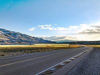
The newest national preserve in Nevada was established July 2015, and contains a large expanse of typical Great Basin landscapes; ridges, mountains, valleys and plains, almost completely undeveloped. The monument extends north and west of the small town of Crystal Springs, at the junction of highways 375, 318 and US 93. Besides the great natural landscapes, the preserve also contains many ancient rock art sites. Description | Photographs | Map |
|
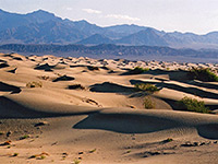
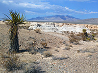
Despite its ominous name, foreboding reputation and extreme climate, visitors to Death Valley will find a place of amazing beauty with many colorful cliffs and canyons, miles of pristine sand dunes, unique evaporative salt features, historical relics and even a diverse range of wildlife. The national park covers 3 million acres making it the largest in the contiguous USA, and contains the lowest point in the Western hemisphere (Badwater, 282 feet below sea level), but also extensive mountainous terrain with elevations up to 11,000 feet. Only just over 3% of the park is in Nevada - a triangle of land west of Beatty. Description | Map | The South | The North | The West | The East |
|
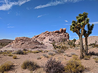
Rugged, undeveloped Mojave Desert region on the north side of Lake Mead, connecting with Grand Canyon-Parashant National Monument in Arizona - landscapes include sandy plains, isolated mountains, red rock formations and narrow canyons, plus Joshua tree forests and many rock art panels. Accessed mostly by unpaved roads. Description | Map |
|
Just 250 miles north of the sunny skies and casinos of Las Vegas lie permanent snowfields and even a small glacier, found near the top of 13,063 foot Wheeler Peak, the central attraction of Great Basin National Park. The area is far from any other famous landmark, and not reached by any major cross-country road, hence visitation is low. Other attractions include a beautiful cave (Lehman Caverns), a ten mile scenic drive into the mountains, many hiking trails and three scenic campgrounds. Description | Photographs | Map |
|
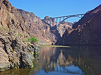
One of several Southwest parks along the Colorado River, Lake Mead NRA is centered on the huge lake formed in 1935 by construction of the Hoover Dam across Black Canyon, 25 miles from Las Vegas. It also contains the smaller Lake Mohave to the south, behind Davis Dam. Both lakes are surrounded by rough, roadless desert lands but the west shoreline of Lake Mead is quite accessible, and has various beaches, marinas, overlooks and picnic areas. Description | Map | Photographs | Hoover Dam | Lake Mohave |
|
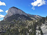
Contains most of the Spring Mountains west of Las Vegas, extending nearly 50 miles, north to south. Centered on the highest peak, 11,918 foot Mt Charleston, a major location for year-round recreation, principally hiking, camping, horse-riding and winter skiing. Scenery includes limestone cliffs, waterfalls, caves and narrow ravines. Part of the Humboldt-Toiyabe National Forest. Description and Map |
|
Created December 19th 2014, this national monument contains an important location for Ice Age fossils, in the desert just north of Las Vegas - on the east side of US 95, adjoining the Desert National Wildlife Refuge. Most of this area is a typically empty plain, centered on a seasonal drainage and its tributaries, and the primary purpose of the national monument is to safeguard the natural resources; visitor facilities are likely to remain very limited. Description and Map |
All Contents © Copyright The American Southwest | Comments and Questions | Contribute | Affiliate Marketing Disclosure | Site Map