Highlights:
Broad tuff plateau between the Sierra Nevada and the White Mountains, associated with the Long Valley Caldera; crossed by shallow ravines lined by photogenic, eroded boulders, some popular for rock climbing. The plateau also contains many Paiute-Shoshone petroglyph panels. Three main access roads: Fish Slough, Chalk Bluff and Casa Diablo.
Nearby town:
Bishop, 5 miles (from the southern edge)
Management:
Location:
37.419, -118.409 (road junction to the southeast)
Seasons:
All year, though winter may bring heavy snowfall
Rating (1-5):
★★★★★

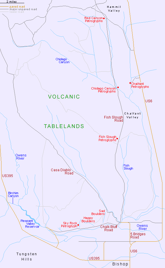
Volcanic Tableland - Roads and Sites
Chalk Bluff Road
Track below the south edge of the plateau, passing two ravines popular for bouldering (Sad Boulders, Happy Boulders), and several rock art panels
Track below the south edge of the plateau, passing two ravines popular for bouldering (Sad Boulders, Happy Boulders), and several rock art panels
Chalfant Petroglyphs
Numerous petroglyphs on a low rhyolite cliff at the edge of Chalfant Valley, on the east side of the Tableland, along US 6
Numerous petroglyphs on a low rhyolite cliff at the edge of Chalfant Valley, on the east side of the Tableland, along US 6
Fish Slough Road
Unpaved road towards the east side of the plateau, passing three major petroglyph sites - Fish Slough, Chidago Canyon and Red Canyon
Unpaved road towards the east side of the plateau, passing three major petroglyph sites - Fish Slough, Chidago Canyon and Red Canyon
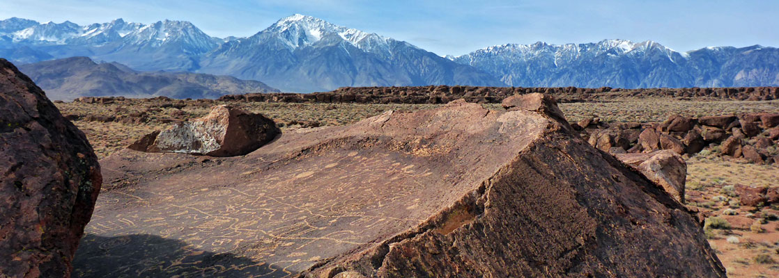
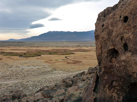
The Volcanic Tableland is a large but relatively little-known area just north of Bishop in Owens Valley, in Mono and Inyo counties, eastern California - a nearly flat plateau of light-colored tuff 20 miles by 14 miles in extent, formed around 765,000 years ago by eruptions to the north, associated with the Long Valley Caldera.
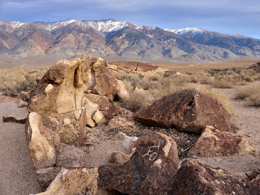
From a distance the place seems empty and barren, unremarkable when set against the dramatic peaks of the Sierra Nevada to the west and the equally grand White mountains to the east - the plateau is little vegetated, crossed only by shallow ravines - yet it has two special features.
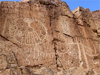
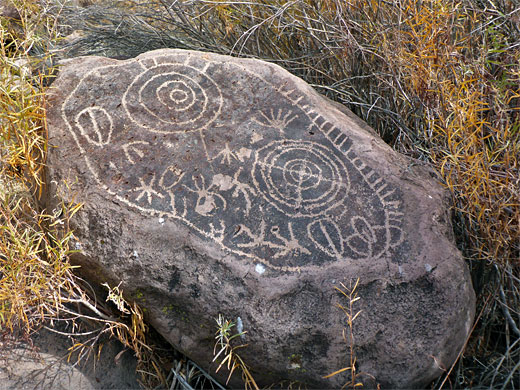
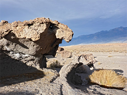
One attraction of the Tableland is the rock art, relic of the Paiute-Shoshone peoples who inhabited this region over 500 years ago (some of the designs may be up to 8,000 years old), carving hundreds of petroglyphs onto the richly colored reddish-brown boulders that are exposed in many areas, mostly alongside the ravines; some of the panels are especially large, intricate and well preserved. The boulders are ignimbrite, a heated, compressed variety of the tuff, formed by pyroclastic flows. Four petroglyph locations have designated trailheads and are relatively easy to find whilst many others are more hidden, less well known.
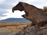
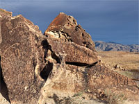
The second feature is the boulders and exposed rocks themselves, of interest both visually, adopting an extraordinary range of eroded shapes, especially photogenic when viewed in conjunction with the mountain backdrops, and also due to their suitability for short-pitch rockclimbing and bouldering; the Tableland has been recognized for several decades as one of the top places for this sport in the whole of the West, along with such locations as Hueco Tanks in Texas, Joshua Tree National Park in California, and Red Rock Canyon in Nevada.
The main bouldering locations are along the south edge of plateau, which forms a dramatic slope (Chalk Bluff) up to 450 feet high, cut by over a dozen short, perpendicular ravines, the two most famous for the climbing being Happy Boulders and Sad Boulders, so-named because one is relatively open and sunny, the other darker and more enclosed.
From a distance the place seems empty and barren, unremarkable when set against the dramatic peaks of the Sierra Nevada to the west and the equally grand White mountains to the east - the plateau is little vegetated, crossed only by shallow ravines - yet it has two special features.
One attraction of the Tableland is the rock art, relic of the Paiute-Shoshone peoples who inhabited this region over 500 years ago (some of the designs may be up to 8,000 years old), carving hundreds of petroglyphs onto the richly colored reddish-brown boulders that are exposed in many areas, mostly alongside the ravines; some of the panels are especially large, intricate and well preserved. The boulders are ignimbrite, a heated, compressed variety of the tuff, formed by pyroclastic flows. Four petroglyph locations have designated trailheads and are relatively easy to find whilst many others are more hidden, less well known.
The second feature is the boulders and exposed rocks themselves, of interest both visually, adopting an extraordinary range of eroded shapes, especially photogenic when viewed in conjunction with the mountain backdrops, and also due to their suitability for short-pitch rockclimbing and bouldering; the Tableland has been recognized for several decades as one of the top places for this sport in the whole of the West, along with such locations as Hueco Tanks in Texas, Joshua Tree National Park in California, and Red Rock Canyon in Nevada.
The main bouldering locations are along the south edge of plateau, which forms a dramatic slope (Chalk Bluff) up to 450 feet high, cut by over a dozen short, perpendicular ravines, the two most famous for the climbing being Happy Boulders and Sad Boulders, so-named because one is relatively open and sunny, the other darker and more enclosed.
Volcanic Tableland Table of Contents
Roads in the Volcanic Tableland
There are three main roads across the Volcanic Tableland, all unpaved, and bumpy in places, but usually suitable for all vehicles including small to medium RVs. All three roads are accessed, in the southeast, from a paved side street (5 Bridges Road) off US 6, just 2 miles from the center of Bishop. All the Tableland is managed by the BLM, and no fees are due for access. US 6 runs along the east edge, in Chalfant Valley, and along here are other rock art sites, the main one being the Chalfant Petroglyphs.
1. Fish Slough Road
A north-south route following close to several minor, seasonal drainages, towards the east side of the plateau, past three groups of petroglyphs all right next to the road, and with maintained trailheads - Fish Slough, Chidago Canyon and Red Canyon. Two other roads provide connections to US 6 in the east.
2. Chalk Bluff Road
An east-west route beside the Owens River at the foot of the steep, boulder-strewn slope marking the south edge of the tuff plateau, past the lower ends of Sad and Happy Boulders, and coming close to several of the more hidden petroglyph locations. After 6 miles it meets the paved road to Pleasant Valley Dam, near a large, riverside campground; US 395 is 1.5 miles south.
3. Casa Diablo Road
A diagonal route across the center of the plateau. The southern reaches are popular as free primitive camping locations, along little side tracks and on verges, while further north the road crosses increasingly remote terrain, eventually entering the wooded foothills of the Benton Range.
Volcanic Tableland - Nearby Places
- Ancient Bristlecone Pine Forest (42 miles) - photogenic trees along the summit ridge of the White Mountains
- Crowley Lake Columns (30 miles) - stone columns and other eroded formations
Volcanic Tableland - Similar Places
- Basin and Range National Monument, Nevada - valleys, plains and mountains, and much rock art
- Spring Valley State Park, Nevada - remote valley through hills of light-colored tuff
All Contents © Copyright The American Southwest | Comments and Questions | Contribute | Affiliate Marketing Disclosure | Site Map