
Lava Tube
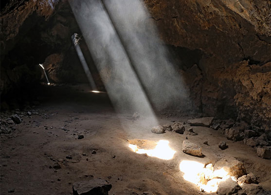
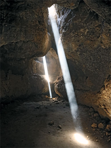
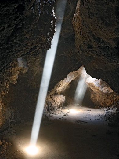
Short lava cave, in a volcanic area of the preserve, illuminated at intervals by small gaps in the ceiling, the light made more evident by dust in the air. Accessed by a short hike and a flight of steps
Length: 0.3 miles
Elevation change: 70 feet
Difficulty: Easy
Type: One way
Usage: Low to medium
Season: All year
Trailhead: Parking area along Aiken Mine Road
Rating (1-5): ★★★★★
Elevation change: 70 feet
Difficulty: Easy
Type: One way
Usage: Low to medium
Season: All year
Trailhead: Parking area along Aiken Mine Road
Rating (1-5): ★★★★★

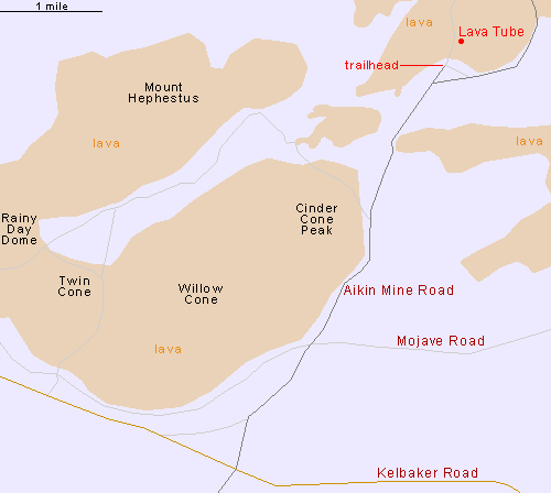
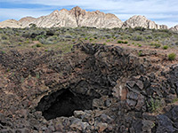
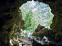
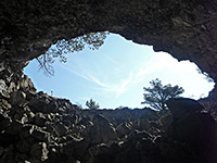
The Cinder Cone Lava Beds are a large area of craters and lava near the center of the Mojave National Preserve, close to Kelbaker Road - on the north side, extending for ten miles, and it also contains several lava caves, one of which has been developed, and has become a relatively popular attraction owing to several small openings in the ceiling through which sunlight can shine, creating enchanting beams in the darkness.
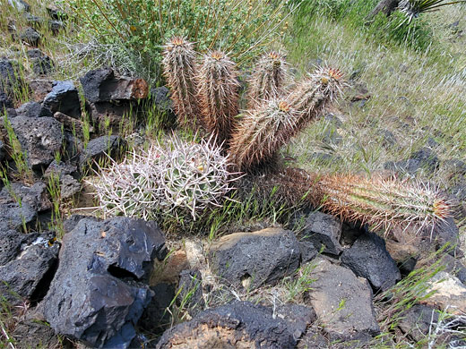
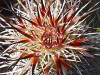
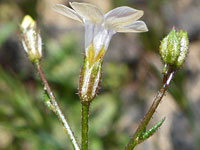
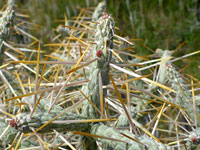
This, the Mojave Desert Lava Tube, is only 330 feet long (and between 16 and 10 feet wide), though is very photogenic, and quite easily reached, starting along Aiken Mine Road, which is unpaved and rather bumpy but generally fine for all vehicles. Around the cave are the usual mix of Mojave Desert vegetation, with a good wildflower selection and several cactus species including Engelmann's hedgehog, beavertail and many-headed barrel.
The lava beds are part of the larger Cima Volcanic Field, which contains around 40 cones and 60 separate lava flows. All are old; the most recent volcanic activity was in the region of 15,000 years ago.
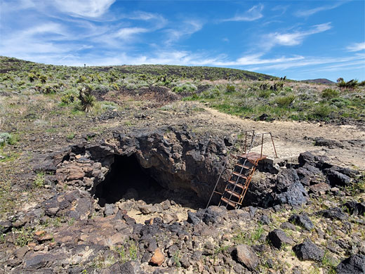
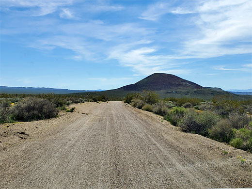
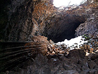
Aiken Mine Road (not signed) forks north off Kelbaker Road 19.7 miles from I-15 and crosses flat desert, stony or sandy, running close to the edge of lava deposits to the west, which incorporate three cinder cones - Twin Cone, Willow Cone and Cinder Cone Peak. The road is ridged for long sections and crosses several little washes where the surface can get rutted if not regularly maintained. The track passes a few places suitable for primitive camping, and several junctions, before reaching the signed trailhead for the cave, 4.8 miles from Kelbaker Road. Just before is another junction where the track continues a short distance to the abandoned Aiken Cinder Mine. From the trailhead, a path, or ATV track, heads north for 0.3 miles then veers right, to the cave entrance, descending via a flight of metal steps.
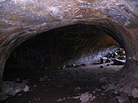
The lava cave is blocked to the right, and open to the left. The passageway is almost completely dark for a little way, then beyond is the skylight section; there is one large double hole and two narrower openings beyond. Light shines through all for several hours around the middle of the day. The floor of the cave is mostly fine sand or earth, and the light beams are made much clearer if the dust is thrown into the air, as it is light enough to remain suspended for a minute or two.
This, the Mojave Desert Lava Tube, is only 330 feet long (and between 16 and 10 feet wide), though is very photogenic, and quite easily reached, starting along Aiken Mine Road, which is unpaved and rather bumpy but generally fine for all vehicles. Around the cave are the usual mix of Mojave Desert vegetation, with a good wildflower selection and several cactus species including Engelmann's hedgehog, beavertail and many-headed barrel.
The lava beds are part of the larger Cima Volcanic Field, which contains around 40 cones and 60 separate lava flows. All are old; the most recent volcanic activity was in the region of 15,000 years ago.
Access
Aiken Mine Road (not signed) forks north off Kelbaker Road 19.7 miles from I-15 and crosses flat desert, stony or sandy, running close to the edge of lava deposits to the west, which incorporate three cinder cones - Twin Cone, Willow Cone and Cinder Cone Peak. The road is ridged for long sections and crosses several little washes where the surface can get rutted if not regularly maintained. The track passes a few places suitable for primitive camping, and several junctions, before reaching the signed trailhead for the cave, 4.8 miles from Kelbaker Road. Just before is another junction where the track continues a short distance to the abandoned Aiken Cinder Mine. From the trailhead, a path, or ATV track, heads north for 0.3 miles then veers right, to the cave entrance, descending via a flight of metal steps.
The Cave
The lava cave is blocked to the right, and open to the left. The passageway is almost completely dark for a little way, then beyond is the skylight section; there is one large double hole and two narrower openings beyond. Light shines through all for several hours around the middle of the day. The floor of the cave is mostly fine sand or earth, and the light beams are made much clearer if the dust is thrown into the air, as it is light enough to remain suspended for a minute or two.
Map of the Lava Tube
Lava Tube - Similar Hikes
All Contents © Copyright The American Southwest | Comments and Questions | Contribute | Affiliate Marketing Disclosure | Site Map