Despite being crossed by many old vehicle tracks, and well suited to off-trail exploration owing to the general lack of dense vegetation, there are few maintained footpaths in the Mojave National Preserve. A selection of the routes are described below.
The Mojave National Preserve Map shows the location of each trail.
 |
|||
| Trail | Length (one way) (miles) |
Elevation Change (feet) |
Trail Description |
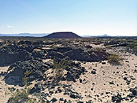
| Amboy Crater | 1.7 | 240 | Although not within the national preserve, nearby Amboy Crater is a popular hiking destination, one reachable by a relatively easy path across twisted lava formations and up the smooth black side of the cinder cone. |
| Hole-in-the-Wall | 0.25 (loop) | level | There are only three developed campsites in the preserve, all in the foothills of the Mid Hills, north of the Providence Mountains. From the Hole-in-the-Wall campground, an easy path loops through the adjacent scrubland, past signs identifying some of the most commonly found plants. |
| Kelso Dunes | 1.5 | 470 | The most accessible sand dunes in the Mojave Preserve are reached by an unpaved track, usually fine for all vehicles, that forks west off the Kelbaker Road, 8 miles south of Kelso. From a parking area at the side of the track, a short, well used trail sets off towards the sand, fading away near the edge, where visitors are free to climb the dunes and explore in any direction, though the usual target is the top of the tallest dune, about 1.5 miles from the road. |
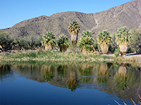
| Lake Tuendae | 0.25 (loop) | level | The western edge of the Mojave National Preserve is marked by a 4.8 mile partly paved road heading south from I-15 (exit 239), to the tiny settlement of Zzyzx - once the site of a health spa established in the 1940s, this is now used by the California State University as a desert study field center. The place was named in order to be the last word in any dictionary. The road ends at some springs beside an area of wetlands centered on Lake Tuendae, on the edge of the salt flats of the much larger Soda Lake. A short loop path around the water's edge has information notices about the lake and the endangered Mojave tui chub fish which live there. |
| Lava Tube | 0.3 | 70 feet | Short lava cave, in a volcanic area of the preserve, illuminated at intervals by small gaps in the ceiling, the light made more evident by dust in the air. Accessed by a short hike and a flight of steps. |
| Mid Hills to Hole-in-the-Wall | 8 | 1,200 | The longest developed trail in Mojave National Preserve links the two main campgrounds, on the eastern side of the Mid Hills; from pinyon and juniper-covered slopes around the Mid Hills camp in the north, the path descends gradually across wide open, flattish land for the most part, covered by bushes and various types of cacti, though much was severely burned in a 2005 wildfire. Near the south end the trail runs along a sandy wash between two flat-topped volcanic hills, then bends east towards the Hole-in-the-Wall campground, nestled beneath more eroded, volcanic rocks. |
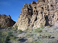
| Rings Trail | 1.5 (loop) | 70 | The Rings Trail descends through a short slot-like ravine (Banshee Canyon) at the edge of the hills close to the Hole-in-the-Wall campground, assisted in two of the steeper parts by a series of ringbolts fastened to the smooth, water-polished canyon walls. The starting point is at the end of a short side road to a picnic area, 0.2 miles north of the Hole-in-the-Wall information center, while the second half of the loop crosses open, cactus-covered desert land at the foot of the cliffs. |
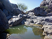
| Rock Spring Trail | 1 (loop) | 120 | This recently constructed (2009) trail starts beside a historic stone cabin, crosses grassy terrain to the edge of a boulder-filled ravine then follows this downstream a short distance to a seasonal pool, or a flowing creek during occasional wet periods. More pools can be seen by scrambling up the ravine. The return part of the loop is over open, undulating desert. |
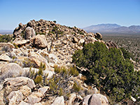
| Teutonia Peak | 2 | 700 | Starting from a layby along Cima Road, the trail to Teutonia Peak passes a Joshua tree forest and an old silver mine then climbs a narrow ridge to a granitic summit that affords nice views over the surrounding desert and mountains. |
| Willow Wash Petroglyphs | 0.2 | level | Small group of petroglyphs along an ancient travel route across the Mojave Desert; reached by a very short hike from Kelbaker Road. |
All Contents © Copyright The American Southwest | Comments and Questions | Contribute | Affiliate Marketing Disclosure | Site Map