Lava Butte and Lava River Cave, Newberry National Volcanic Monument
Oregon > Newberry National Volcanic Monument > Lava Butte and Lava River Cave
Highlights:
The most easily accessed section of Newberry National Volcanic Monument, alongside US 97; lava flows, cinder cones, volcanoes and lava caves
Location:
43.917, -121.356 (Lava Butte)

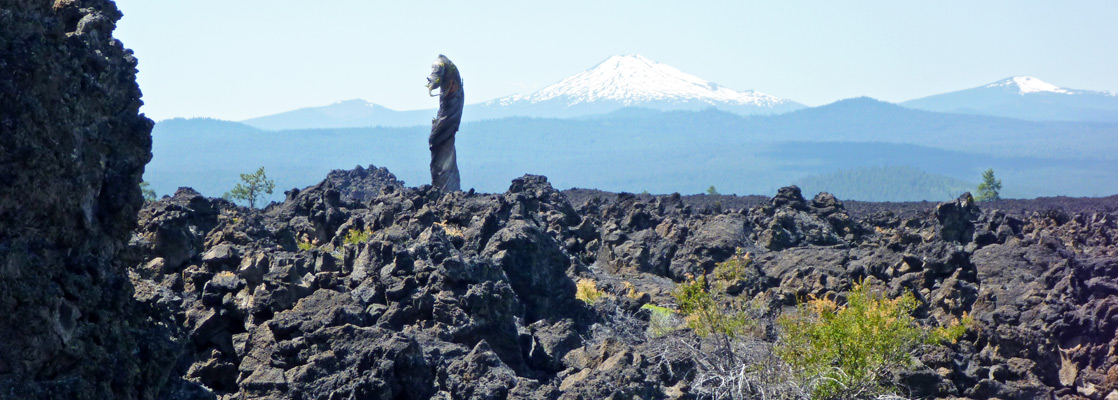
Newberry National Volcanic Monument is a large preserve, covering 30 miles of the Deschutes National Forest south of Bend, and whilst the most spectacular scenery is in the Paulina Caldera area, the easiest accessed section is along US 97, where two major volcanic features may be explored by short trails. One is Lava River Cave, the longest known lava tube in Oregon; steps take visitors 150 feet down to the floor of a smooth-walled cavern, which may be followed for nearly a mile. The other, on the far side of the highway, is Lava Butte, a symmetric cinder cone at the edge of a big flow of jagged, jet black lava, stretching six miles to the Deschutes River.
The nearby Lava Lands Visitor Center includes a museum, bookstore and video theater, and acts as the main information point for the whole national monument, while three short and one long trails lead into and alongside the lava fields. Other facilities are a picnic area and a short scenic drive to the top of the butte. Both the main features may be seen in less than half a day, hence this is a good stop along the 90 mile journey from Bend to Crater Lake National Park.
The nearby Lava Lands Visitor Center includes a museum, bookstore and video theater, and acts as the main information point for the whole national monument, while three short and one long trails lead into and alongside the lava fields. Other facilities are a picnic area and a short scenic drive to the top of the butte. Both the main features may be seen in less than half a day, hence this is a good stop along the 90 mile journey from Bend to Crater Lake National Park.
Lava Tube Tour
Guided tour of a lava tube cave, near Bend.
Map of Lava Butte and Lava River Cave

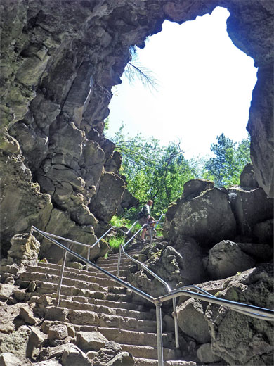
Lava River Cave
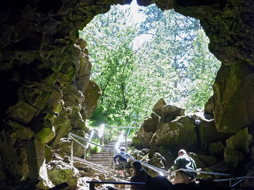
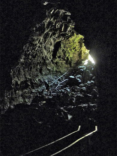
The entrance to Lava River Cave is just 700 feet from US 97, accessed by a parallel road linking exit 151 (Cottonwood Road) with the Lava Lands Visitor Center, a relatively new route completed in 2011. The cave is very popular so has a large parking area, and a kiosk where propane lanterns may be rented. A short collapsed section of the tube provides easy entry. The southeast portion of the cave is rather narrow, contains unstable ceiling rocks, and is closed to the public but the longer northwestern part is unobstructed, and straightforward to follow. The descent is aided by steps and railings, down 150 feet through a slope of fallen boulders to the floor, which remains flat and level all the way, apart from a few small downward steps. Long ridges along the walls mark differing levels of the flowing lava, and the ceiling is lined with solidified droplets (lavacicles), where molten rock once dripped. The cave soon passes under US 97, at which point the roof is 30 feet thick, then continues northwards; progress is indicated by several notices giving distances and background information. Other features include a sand garden, a section of double tube and several pools, though most of the tunnel is dry. The far end becomes smaller, the floor sandier, and the final few hundred feet have been dug out; the cave does continue for an unknown distance, even narrower, and completely blocked by sand.
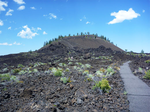
Lava Butte
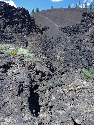
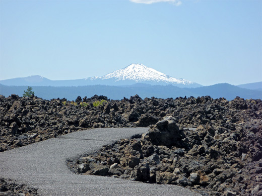
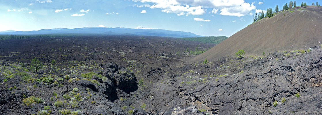
Lava Butte rises 600 feet right next to busy highway US 97; a side road forks off reaching Benham Falls on the Deschutes River after 4 miles, while another road leads to the various visitor facilities. A short gravel track (not suitable for RVs) climbs to the top of the butte, from where a quarter mile trail circles the small, 150 foot deep crater on the summit, giving very good views of the 7,000-year old lava flow below, across to the distant, snowy peaks of the central Cascade Range. Other paths start near the entrance; most popular is Trail of the Molten Land (0.75 miles), a paved, partial loop over the lava, with a spur to a high viewpoint on the south side of the butte, next to a lateral vent through which most of the lava was produced. Features en route include squeeze ups, lava balls and lava drains, and again the vistas are impressive, over forest and lava towards Mount Bachelor and the Three Sisters. The lava shelters a few wildflowers, bushes and an occasional tree but most is entirely barren of vegetation. The third of a mile Whispering Pines Trail loops past a section of lava close to the ponderosa pine forest, while the longer Black Rock Trail skirts the edge of the forest for several miles westwards. All the lava is of the jagged aa type; the ropey pahoehoe form may however be found in the vicinity of the Lava Cast Forest, 13 miles (by road) southeast.
All Contents © Copyright The American Southwest | Comments and Questions | Contribute | Affiliate Marketing Disclosure | Site Map