Paulina Lake Area, Newberry National Volcanic Monument
Oregon > Newberry National Volcanic Monument > Pauline Lake/Newberry Caldera
Highlights:
The largest and most interesting section of Newberry National Volcanic Monument, centered on the flooded caldera of Newberry Volcano; also contains lava flows, volcanic peaks, waterfalls and canyons, with many visitor facilities, including 11 trails
Location:
43.721, -121.258 (Paulina Lake)

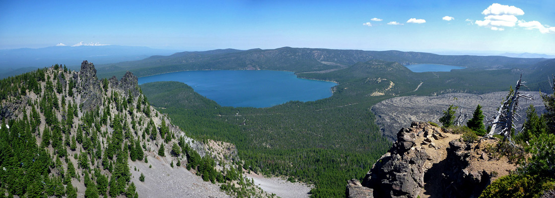
The most interesting section of Newberry National Volcanic Monument is around Paulina Lake, at the center of Newberry Crater. This is reached by a good, paved road, usually snow-free from May to November, that leaves US 97 near La Pine, 22 miles south of Bend, and is straight at first, through land of the Deschutes National Forest, then more winding as it climbs to the caldera rim.
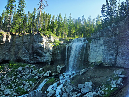
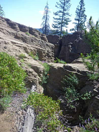
After the entrance station (fees $5 per vehicle in 2024), the first site is Paulina Falls, where Paulina Creek, the exit stream of the lake, splits into two channels which drop 80 feet over sheer basalt cliffs onto a group of jagged boulders. The cascade is accessed by a short trail through tall, damp, shady woodland; an area likely to be infested with mosquitoes during summer. Just past the falls, the road emerges from the forest at the southwest corner of Paulina Lake, beside the visitor center, a side road to Paulina Lake Lodge, and one of the six campgrounds, reflecting the fact that camping is the main recreational activity hereabouts, plus fishing (for kokanee salmon and brown trout) and boating.
After the entrance station (fees $5 per vehicle in 2024), the first site is Paulina Falls, where Paulina Creek, the exit stream of the lake, splits into two channels which drop 80 feet over sheer basalt cliffs onto a group of jagged boulders. The cascade is accessed by a short trail through tall, damp, shady woodland; an area likely to be infested with mosquitoes during summer. Just past the falls, the road emerges from the forest at the southwest corner of Paulina Lake, beside the visitor center, a side road to Paulina Lake Lodge, and one of the six campgrounds, reflecting the fact that camping is the main recreational activity hereabouts, plus fishing (for kokanee salmon and brown trout) and boating.
Newberry Caldera Table of Contents
Paulina Peak and the Lakes
The road continues another six miles, close to but out of sight of the south side of Paulina Lake, past the entrances to three more campgrounds, over a low ridge then all along the shore of East Lake, ending at the furthest campground (Cinder Hill). One other junction en route is opposite East Lake Resort, where unpaved Hwy 21 crosses the southeast corner of the monument and exits into the adjacent national forest. The two lakes themselves are not especially scenic, mostly bordered by flattish, wooded land; volcanic cliffs are found only in one short section on the west side of East Lake, though area this lies beyond a private inholding so is not easily reached. Surrounding the lakes are various cinder cones, craters and summits, of which by far the most prominent is Paulina Peak, south of Paulina Lake. The top of the mountain is reachable by trail, but also by the unpaved Paulina Peak Road, usually open (to vehicles less than 18 feet) between July and October. The summit provides 360° views over the volcanic landscapes below, extending as far as Mount Hood and Mount Shasta on clear days.
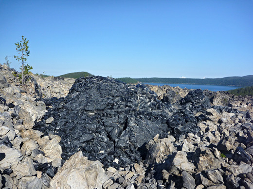
Big Obsidian Flow
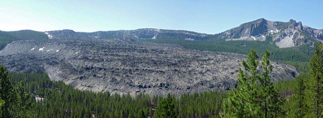
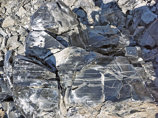
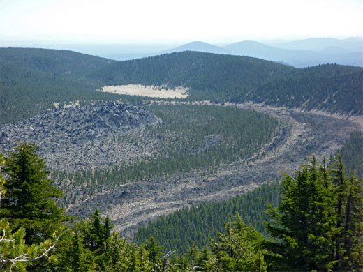
Paulina Peak may be the most visible feature in this section of the national monument, but more unusual is the Big Obsidian Flow - over a mile of black volcanic glass mixed with grey pumice, from lava that solidified 1,300 years ago after pouring down a hillside just east of the peak. Both small scale ripples and large flow patterns are still very evident, and the lava remains almost completely unvegetated. A half mile partial loop path climbs a little way up the northern edge, starting at a parking area in the forest on the south side of the road. The Obsidian Flow Trail passes through a belt of woodland, ascends the side of the flow via steps, up to a flatter area, then winds through the irregular blocks, of which the pumice predominates but there are many areas of jet black obsidian, often crossed by very thin white bands. The start of the trail overlooks part of Lost Lake, a thin narrow pool curving along the base of the lava flow.
Little Crater Trail
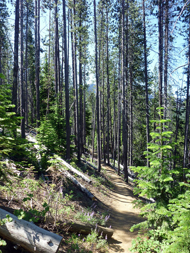
The Obsidian Flow Trail is the only one clearly marked along the highway; most roadside notices are for campgrounds and other popular facilities. The remaining paths are rather less used, but a second good, short route is the Little Crater Trail, which loops around the mostly forested rim of a small crater between the two lakes, crossing some open areas that give elevated views of the lakes, Paulina Peak and the Big Obsidian Flow. This starts along the side road to Little Crater Campground, at the same place as the short Silica Trail that traverses wooded land and connects with the Obsidian Flow route. Both are for hikers only, unlike the some of the longer trails which are also open to bikes and horses. The Little Crater Trail leads into the forest, climbing a little, past a volcanic outcrop to a junction, at the start of a one mile loop. The left fork ascends more, zig zagging up the hillside close to the lake, and reaches a second junction, with a connecting path from the north end of the campground. Near here is a treeless viewpoint of Paulina Lake, followed, after the last part of the climb up an exposed ridge, by a better overlook, where the panorama extends nearly all around, across Paulina Peak, Central Pumice Cone and East Lake. A deep crevasse through layered pumice is evidence of the volcanic origins of the Little Crater, which also has a neat circular shape though the trees prevent a good overall view. The trail starts to descend, heading south then west, past several vantage points of the Obsidian Flow, high enough to appreciate all the rippled patterns on its surface. The final portion drops down into the crater, soon arriving back at the start of the loop. The path seems not often hiked but is quite enjoyable, because of the long distance views rather than the immediate surroundings. The lightly wooded slopes harbor many summer wildflowers, and mosquitoes.
All Newberry Caldera Trails
| Trail | Length (one way) (miles) |
Elevation Change (feet) |
Trail Description |
| Crater Rim | 21 (loop) | 1,300 | This long loop trail circles all of the caldera rim; from the west entrance road it follows close to the shoreline of Paulina Lake, climbs towards North Paulina Peak then stays fairly level for many miles, all around East lake, across Hwy 21 and past the south edge of the Big Obsidian Flow. The last section ascends gradually, most of the way to the summit of Paulina Peak, before a steep descent back towards the visitor center. Three link paths allow for individual segments to be hiked as part of shorter loops. |
| Little Crater | 1.5 (loop) | 500 | The Little Crater Trail circles the rim of a tree-covered crater near Paulina Lake. En route are several volcanic outcroppings, and (in a few places) good views in all directions. |
| Lost Lake | 4 | 350 | Lost Lake is a long, thin pond at the base of the Big Obsidian Flow. A path heads south past one end of the lake, then climbs steadily, staying close to the edge of the lava and some adjacent pumice flats, then on to an intersection with the Crater Rim Trail. |
| Newberry Crater | 9 | 1,000 | Starting in the west at the visitor center near Paulina Creek, this trail parallels the road, staying on the south side and connecting various campgrounds and trailheads. After passing the most distant campground (Cinder Hill), the path climbs the hills above East Lake to a junction with the Crater Rim Trail. |
| Obsidian Flow | 0.5 | 500 | The most popular trail in the national monument penetrates a short distance into the jagged pumice and lava of the Big Obsidian Flow, accompanied by interpretive notices describing the geology and local wildlife. The trailhead is along the road 2 miles east of the visitor center. |
| Parallel | 2 | 550 | The Parallel Trail runs alongside the unpaved portion of Hwy 21, providing an alternative to the road for hiking between East Lake and the Crater Rim Trail. It is mostly used by horses. |
| Paulina Falls | 0.25 | 150 | The shortest trail in the national monument descends a wooded hillside to a viewing area near the base of an 80 foot waterfall along Paulina Creek. |
| Paulina Lakeshore | 7.5 | 250 | This loop path circles all around Paulina Lake, staying close to the water the whole way. It can be joined at either the Paulina Lake, Newberry Group or Little Crater campgrounds. |
| Paulina Peak | 0.25 | 200 | The short spur trail to 7,984 foot Paulina Peak branches off the Crater Rim Trail a little way below the summit. This location is more easily reached by the gravel Paulina Peak Road. |
| Peter Skene Ogden | 8.6 | 2,000 | Used mostly by cycles (uphill only) and horses, the Peter Skene Ogden Trail parallels the north side of Paulina Creek, from Paulina Lake Lodge to a lower trailhead outside the national monument, along Hwy 21 2.8 miles from US 97. |
| Silica | 0.5 | level | The Silica Trail connects Little Crater Campground with the trailhead near Big Obsidian Flow, crossing a flat, wooded area. |
All Contents © Copyright The American Southwest | Comments and Questions | Contribute | Affiliate Marketing Disclosure | Site Map