Hilton Creek Lakes Trail
Trail up a east-facing slope above Rock Creek Road, then through fairly level woodland, followed by a climb above the treeline, following a stream to a spectacular group of lakes, close to the Sierra crest
Length: 5 miles, to the 7th and 8th lakes
Elevation change: 1,350 feet
Difficulty: Moderate; not too steep, easy-to-follow trail
Type: One-way, partial loop at the end
Usage: Low
Season: Early summer to early fall
Trailhead: Pine Grove Campground, along Rock Creek Road. Also accessible from Rock Creek Lake, further along the road
Rating (1-5): ★★★★★

Hilton Creek in the eastern Sierra Nevada is a short drainage, 9 miles, that flows into the south end of Crowley Lake, originating in a group of lakes and ponds, some right below the Sierra crest. Most are enclosed in a spectacular granite basin, above the treeline, with slopes and peaks on three sides, major summits being Pointless Peak, Mount Huntington and Hilton Peak. This beautiful, relatively little-visited area may be explored via a not too difficult hike of up to 6 miles, starting from either of two places along Rock Creek Road, a paved route into the mountains, leading to Little Lakes Valley.
The path from the closer trailhead, at Pine Grove Campground, climbs an aspen slope then traverses flattish terrain through light woodland, before a short ascent, moving beyond the upper edge of the trees, to the Third Lake; the lakes in the basin are numbered one to ten. The path splits soon after, the two branches leading to lakes four and five, while others can be seen by cross-country hiking; the suggested hike here, a partial loop, also visits lakes six, seven and eight making a ten mile round-trip.
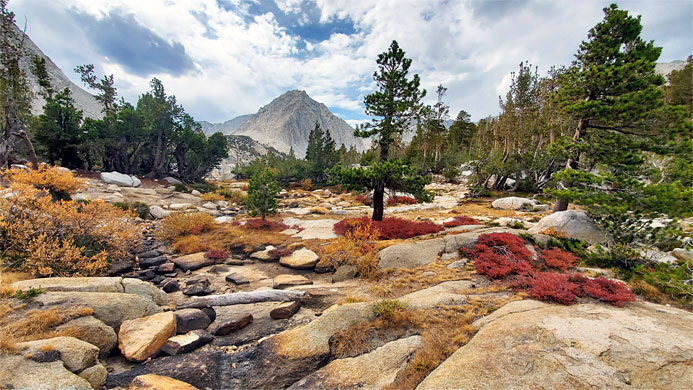
All these upper lakes are very photogenic, surrounded by meadows, scree slopes, boulder piles, cliffs and boggy areas; varied habitats which support a good variety of summer wildflowers.
The Hilton Creek Lakes hike can begin from a trailhead on the north side of Rock Creek Lake, though a shorter approach is one mile back along Rock Creek Road, parking at a small day use area at the entrance to Pine Grove campground, in wooded surroundings right next to the creek. The unsigned trail starts by climbing the slope on the west side of the valley, through boulders and scattered trees, mainly aspen and California juniper, some of which are very aged, and barkless, the wood a rich red/brown color, similar to bristlecone pines. After rising 570 feet in a little over half a mile, the path reaches flat land on the rim of the valley and meets the other trail, from Rock Creek Lake; ahead the (northwards) path is now signed to the Hilton Creek Lakes.
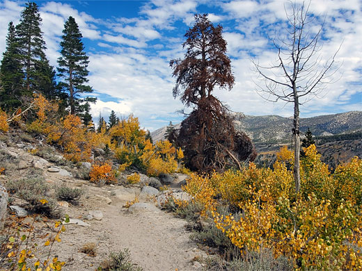
Ahead, the trail encounters a similar mix of white granite boulders and aspen, scenery that is especially pretty in the fall. The path crosses a small spring-fed stream, lined by lupine, then descends slightly through a patch of pines and continues to a more open area, still with scattered aspen. It crosses another small stream, cuts back south to avoid a patch of boulders then heads north once more, now moving well away from Rock Creek valley, traversing flat, sandy land, rather uninspiring, and generally dry, apart from a large sloping boggy area close by to the right, just after which the trail starts a gentle ascent, winding up the wooded slope, as the trees become smaller and the boulders bigger. The route crosses a minor saddle and descends via constructed steps at one point, back into dense woodland and onto a moist, flat area where the trail divides.
The right branch visits the lower two Hilton Creek lakes; numbers one (Davis Lake), and two, both of which have wooded surroundings, then follows Hilton Creek all the way to Crowley Lake village, while the left branch is to the upper lakes. This path has a short, steep ascent via switchbacks, through the trees until, an abrupt transition from the still quite dense woodland to spectacular, expansive granite scenery. A stony, wildflower-rich corridor along a stream leads to Third Lake, bordered by a steep, unvegetated scree slope to one side, below Pointless Peak, and by bushes and stunted trees to the other side, now with the Sierra crest clearly visible in the distance, to the south.
The path follows close to Third Lake, a little way up on a ridge, though it is just as easy to walk directly along the shoreline, to the upper end, rejoining the path as it rises again, by another 300 feet, to the next lake, Fifth, which is smaller though similar in aspect, with a marshy area on the far side where flowers include the rare alpine gentian. The path follows the western shoreline a way, climbs above then drops back down, now following the inlet stream, to the confluence with another stream, from Sixth Lake, visible close by to the west.
The trail seems to stop around here, but the continuation route is straightforward - further along the Fifth Lake entry stream, through a meadow then up a bouldery gully to the brink of Eighth Lake, the penultimate one in this direction; ahead, Ninth Lake is half a mile further, while almost adjacent, to the west is Seventh Lake, separated from the eighth only by an narrow granite ridge. Also out-of-sight to the south, is the most distant of all the lakes, number 10. Yet another lake is close by to the north; this is number six, reached by a short walk through a meadow, almost back to the approach path.
From Sixth Lake, an alternative return is to walk northwards, soon into the upper end of a boulder-filled gully, which leads steadily down, eventually reaching the east end of Fourth Lake which is about as large as the first one encountered (Third) and equally pretty, with photogenic reflections of the surrounding cliffs and trees. A walk along the east shore of Fourth Lake, across some boulders and through flat woodland, reaches the northern edge, where a path resumes. This descends a little, coming close to one stream and crossing another, in the middle of a meadow. A pretty pond is just beyond, after which the path rises slightly, crosses a plateau and rejoins the initial trail, close to Third Lake.
The path from the closer trailhead, at Pine Grove Campground, climbs an aspen slope then traverses flattish terrain through light woodland, before a short ascent, moving beyond the upper edge of the trees, to the Third Lake; the lakes in the basin are numbered one to ten. The path splits soon after, the two branches leading to lakes four and five, while others can be seen by cross-country hiking; the suggested hike here, a partial loop, also visits lakes six, seven and eight making a ten mile round-trip.
All these upper lakes are very photogenic, surrounded by meadows, scree slopes, boulder piles, cliffs and boggy areas; varied habitats which support a good variety of summer wildflowers.
Rock Creek Road
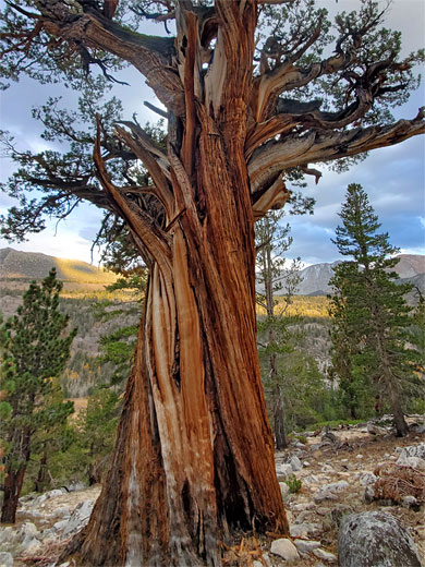
The Hilton Creek Lakes hike can begin from a trailhead on the north side of Rock Creek Lake, though a shorter approach is one mile back along Rock Creek Road, parking at a small day use area at the entrance to Pine Grove campground, in wooded surroundings right next to the creek. The unsigned trail starts by climbing the slope on the west side of the valley, through boulders and scattered trees, mainly aspen and California juniper, some of which are very aged, and barkless, the wood a rich red/brown color, similar to bristlecone pines. After rising 570 feet in a little over half a mile, the path reaches flat land on the rim of the valley and meets the other trail, from Rock Creek Lake; ahead the (northwards) path is now signed to the Hilton Creek Lakes.

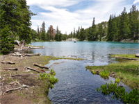
Trail through the Woods
Ahead, the trail encounters a similar mix of white granite boulders and aspen, scenery that is especially pretty in the fall. The path crosses a small spring-fed stream, lined by lupine, then descends slightly through a patch of pines and continues to a more open area, still with scattered aspen. It crosses another small stream, cuts back south to avoid a patch of boulders then heads north once more, now moving well away from Rock Creek valley, traversing flat, sandy land, rather uninspiring, and generally dry, apart from a large sloping boggy area close by to the right, just after which the trail starts a gentle ascent, winding up the wooded slope, as the trees become smaller and the boulders bigger. The route crosses a minor saddle and descends via constructed steps at one point, back into dense woodland and onto a moist, flat area where the trail divides.
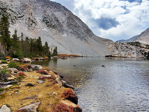

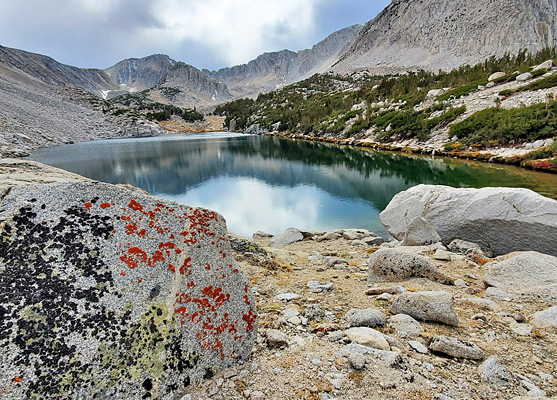
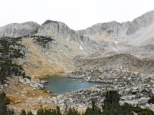
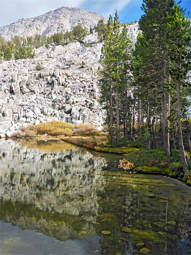
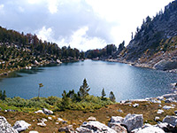
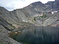
Third Lake
The right branch visits the lower two Hilton Creek lakes; numbers one (Davis Lake), and two, both of which have wooded surroundings, then follows Hilton Creek all the way to Crowley Lake village, while the left branch is to the upper lakes. This path has a short, steep ascent via switchbacks, through the trees until, an abrupt transition from the still quite dense woodland to spectacular, expansive granite scenery. A stony, wildflower-rich corridor along a stream leads to Third Lake, bordered by a steep, unvegetated scree slope to one side, below Pointless Peak, and by bushes and stunted trees to the other side, now with the Sierra crest clearly visible in the distance, to the south.
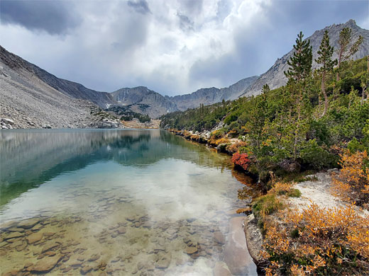
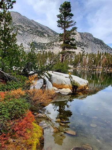
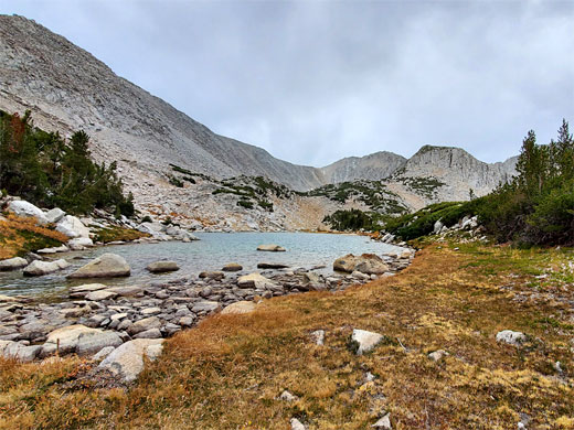
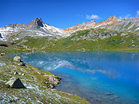
Fifth Lake
The path follows close to Third Lake, a little way up on a ridge, though it is just as easy to walk directly along the shoreline, to the upper end, rejoining the path as it rises again, by another 300 feet, to the next lake, Fifth, which is smaller though similar in aspect, with a marshy area on the far side where flowers include the rare alpine gentian. The path follows the western shoreline a way, climbs above then drops back down, now following the inlet stream, to the confluence with another stream, from Sixth Lake, visible close by to the west.
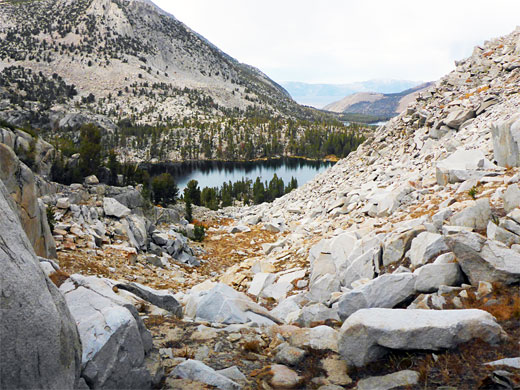
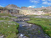
Seventh and Eighth Lakes
The trail seems to stop around here, but the continuation route is straightforward - further along the Fifth Lake entry stream, through a meadow then up a bouldery gully to the brink of Eighth Lake, the penultimate one in this direction; ahead, Ninth Lake is half a mile further, while almost adjacent, to the west is Seventh Lake, separated from the eighth only by an narrow granite ridge. Also out-of-sight to the south, is the most distant of all the lakes, number 10. Yet another lake is close by to the north; this is number six, reached by a short walk through a meadow, almost back to the approach path.
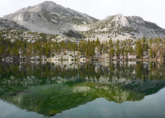
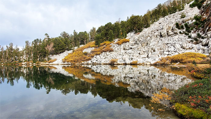
Fourth Lake
From Sixth Lake, an alternative return is to walk northwards, soon into the upper end of a boulder-filled gully, which leads steadily down, eventually reaching the east end of Fourth Lake which is about as large as the first one encountered (Third) and equally pretty, with photogenic reflections of the surrounding cliffs and trees. A walk along the east shore of Fourth Lake, across some boulders and through flat woodland, reaches the northern edge, where a path resumes. This descends a little, coming close to one stream and crossing another, in the middle of a meadow. A pretty pond is just beyond, after which the path rises slightly, crosses a plateau and rejoins the initial trail, close to Third Lake.
Hilton Creek Lakes Wildflowers
More flowers along the trail
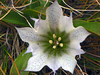 Alpine gentian |
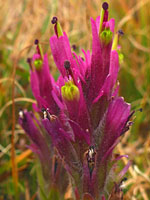 Lemmon's indian paintbrush |
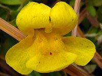 Tiling's monkeyflower |
More flowers along the trail
Hilton Creek Lakes Trail - Similar Hikes
All Contents © Copyright The American Southwest | Comments and Questions | Contribute | Affiliate Marketing Disclosure | Site Map