Upper Woods Canyon
Upstream end of a long canyon, starting as a shallow valley in the pine woods, deepening through layers of grey basalt, giving way to a narrow, sheer-walled sandstone gorge, with many pools and boulders. Explored by an off-trail hike. Good for wildflowers
Length: 4 miles, to the big pool
Elevation change: 1,150 feet
Difficulty: Strenuous
Type: One way, off-trail
Usage: Very low
Season: Spring, summer and fall; affected by snow in the winter
Trailhead: Fox Ranch Road, I-17 exit 317
Rating (1-5): ★★★★★
Elevation change: 1,150 feet
Difficulty: Strenuous
Type: One way, off-trail
Usage: Very low
Season: Spring, summer and fall; affected by snow in the winter
Trailhead: Fox Ranch Road, I-17 exit 317
Rating (1-5): ★★★★★

Woods Canyon is a long drainage, over 30 miles, cutting through the wooded plateau southeast of Sedona and, towards its lower end, containing a seasonal stream, Dry Beaver Creek, which meets Wet Beaver Creek near Montezuma Castle. The downstream end of the gorge may be explored by the Woods Canyon Trail, 5 miles, but above here the deepest and most scenic section is pathless, and rarely explored. The canyon extends another 10 miles upstream, to the vicinity of I-17, where the drainage becomes temporarily shallow, though it deepens somewhat on the far side the freeway.
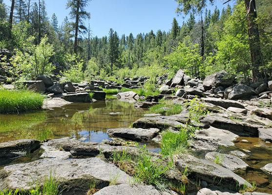
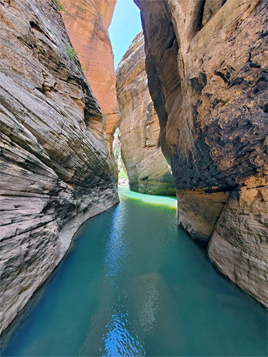
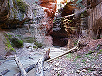
An excellent half day hike is to descend the canyon from near the interstate crossing; the streambed gradually cuts into into the basalt bedrock, through a sequence of large, permanent pools, surrounded by much vegetation, then enters the underlying Coconino sandstone layer, becoming confined between vertical cliffs, still deepening steadily and after about 4 miles reaching a long, cold and deep pool of greenish-blue water, between sheer, overhanging walls.
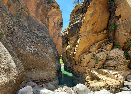
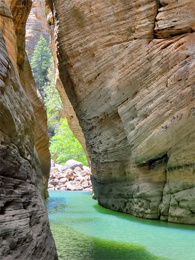
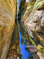
The big pool marks the end of (relatively) easy hiking, as continuing would require a swim, of maybe 150 feet. In another mile of mostly open passageways the rocks around the streambed change again, now to the red Supai Formation, and the scenery becomes even prettier, but just the section to the big pool is spectacular enough.
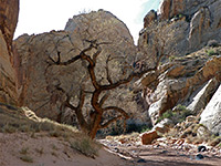
A suitable parking place to explore the upper section of the Woods Canyon gorge is the start of Fox Ranch Road, I-17 exit 317, at the entrance to a forest track signed 9460R. This track branches a few times in the pine woods, and there are good places for primitive camping here, just a little noisy from the interstate. The walking route to the canyon is due south from the start of the track, for one mile; over a fence, up a short but steep slope, across a ridgetop then gently, steadily down through the open woodland, the ground sprinkled with spring wildflowers, including Gunnison's mariposa lily.
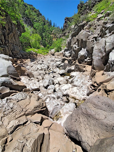
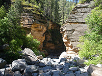
The canyon at this point is shallow and easy to enter, lined by low slopes covered with the grey basalt boulders. The suggested entry point is on the north side of a bend, from where just downstream is the first of around ten large pools, holding water all year. A tiny stream is usually flowing, in some places over flat rock terraces, in others disappearing amongst the boulders. Two more pools in quick succession are followed by a more overgrown section where progress is slowed, and then a few more pools, before a rockier corridor, with less vegetation. White salt deposits mark the position of dried-up pools, as the canyon is much wetter during the snowmelt season.
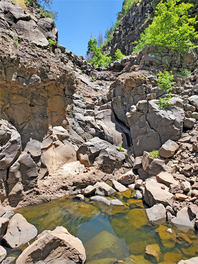
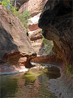
The canyon deepens more steeply, including via a slanted basalt dryfall above a big pool, and the floor becomes covered by larger borders. The cliffs are now vertical, black-brown basalt, like parts of upper Sycamore Canyon. The drainage narrows as the Coconino Sandstone layer appears (topped by the Toroweap Formation), quite abruptly, at a geological fault; at first there is a long straight section, about half a mile, then two bends, and a descent to the edge of the big pool, for which there is no obvious bypass route and so swimming is the only option to continue. For the return hike, an alternative to walking all the way back to the entrance point is to ascend a bushy slope on the north side, on the inside of a U-shaped bend, a little way past the start of the Coconino layer; up 400 feet, back to the pine woods plateau.
An excellent half day hike is to descend the canyon from near the interstate crossing; the streambed gradually cuts into into the basalt bedrock, through a sequence of large, permanent pools, surrounded by much vegetation, then enters the underlying Coconino sandstone layer, becoming confined between vertical cliffs, still deepening steadily and after about 4 miles reaching a long, cold and deep pool of greenish-blue water, between sheer, overhanging walls.
The big pool marks the end of (relatively) easy hiking, as continuing would require a swim, of maybe 150 feet. In another mile of mostly open passageways the rocks around the streambed change again, now to the red Supai Formation, and the scenery becomes even prettier, but just the section to the big pool is spectacular enough.

The Approach
A suitable parking place to explore the upper section of the Woods Canyon gorge is the start of Fox Ranch Road, I-17 exit 317, at the entrance to a forest track signed 9460R. This track branches a few times in the pine woods, and there are good places for primitive camping here, just a little noisy from the interstate. The walking route to the canyon is due south from the start of the track, for one mile; over a fence, up a short but steep slope, across a ridgetop then gently, steadily down through the open woodland, the ground sprinkled with spring wildflowers, including Gunnison's mariposa lily.
Basalt Gorge
The canyon at this point is shallow and easy to enter, lined by low slopes covered with the grey basalt boulders. The suggested entry point is on the north side of a bend, from where just downstream is the first of around ten large pools, holding water all year. A tiny stream is usually flowing, in some places over flat rock terraces, in others disappearing amongst the boulders. Two more pools in quick succession are followed by a more overgrown section where progress is slowed, and then a few more pools, before a rockier corridor, with less vegetation. White salt deposits mark the position of dried-up pools, as the canyon is much wetter during the snowmelt season.

Sandstone Narrows
The canyon deepens more steeply, including via a slanted basalt dryfall above a big pool, and the floor becomes covered by larger borders. The cliffs are now vertical, black-brown basalt, like parts of upper Sycamore Canyon. The drainage narrows as the Coconino Sandstone layer appears (topped by the Toroweap Formation), quite abruptly, at a geological fault; at first there is a long straight section, about half a mile, then two bends, and a descent to the edge of the big pool, for which there is no obvious bypass route and so swimming is the only option to continue. For the return hike, an alternative to walking all the way back to the entrance point is to ascend a bushy slope on the north side, on the inside of a U-shaped bend, a little way past the start of the Coconino layer; up 400 feet, back to the pine woods plateau.

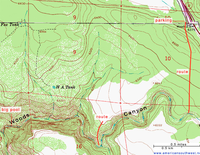
Topographic Map of Upper Woods Canyon
Woods Canyon Wildflowers
More flowers in the canyon
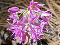 Twincrest onion |
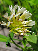 Long-stalked clover |
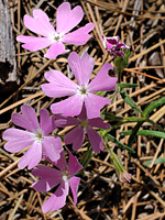 Showy phlox |
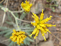 Fineleaf hymenopappus |
More flowers in the canyon
Upper Woods Canyon - Similar Hikes
All Contents © Copyright The American Southwest | Comments and Questions | Contribute | Affiliate Marketing Disclosure | Site Map