Observation Point Trail, Yellowstone National Park
Wyoming > Yellowstone National Park > The Southwest > Hiking > Observation Point Trail
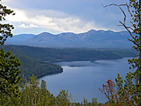
Observation Point
This well used path climbs a short, steep, wooded hillside to a viewpoint of Old Faithful and nearby features, then continues across the hill to Solitary Geyser, a bubbling pool in an open area of the forest
Length: 1.1 miles, round trip
Elevation change: 160 feet
Difficulty: Easy
Type: Loop; links with other trails in the Upper Geyser Basin
Usage: High
Season: Late spring, summer, fall
Trailhead: Near Old Faithful
Rating (1-5): ★★★★★
Elevation change: 160 feet
Difficulty: Easy
Type: Loop; links with other trails in the Upper Geyser Basin
Usage: High
Season: Late spring, summer, fall
Trailhead: Near Old Faithful
Rating (1-5): ★★★★★

Although it starts right in the busiest part of Yellowstone National Park next to Old Faithful in the Upper Geyser Basin, the 1.1 mile (loop) Observation Point Trail is relatively little used, and provides a quick excursion into the park's backcountry, visiting a grand viewpoint of Geyser Hill and Old Faithful Village, and continuing to an isolated thermal area (Solitary Geyser).
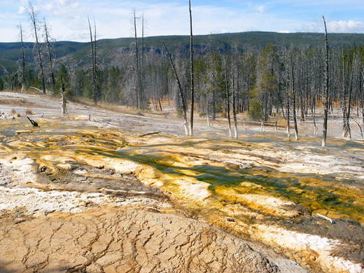
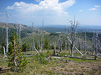
Some parts of the route are a little steep but most is quite easy, and passes through a mixture of new growth pine woodland (after the 1988 wildfires) and surviving old forest; the loop takes around half an hour, not counting time spent waiting for the geyser to erupt.
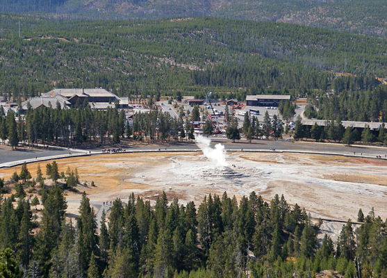
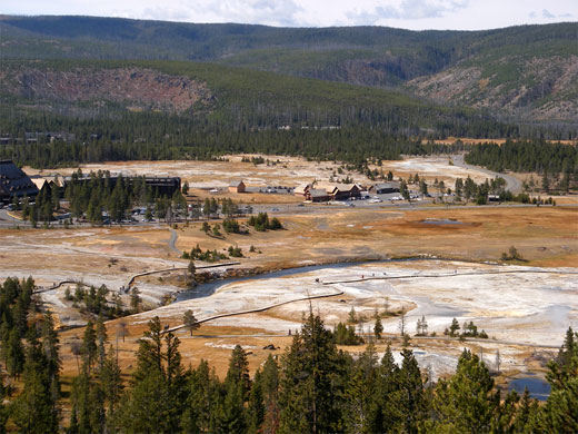
Parking for the hike is at Old Faithful Village. The trail begins just north of Old Faithful itself, crosses the Firehole River and very soon reaches a junction with the much longer route to Mallard Lake, after which the path enters the fire-damaged forest, staying level at first then climbing slightly to a second junction. Turning right, a rather steeper ascent reaches Observation Point, about 200 feet above and a third of a mile distant from Old Faithful. The valley below is somewhat obscured by trees but all of Old Faithful Village is in full view, as is the next set of geysers to the north (Geyser Hill). This place is a good alternative location from which to watch an Old Faithful eruption, as although much further away than the regular viewing platform, the overlook gives a better sense of scale and perspective.
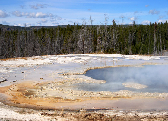
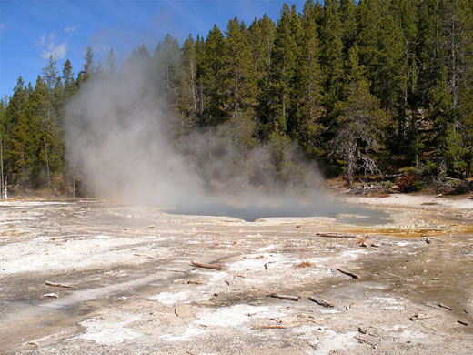
The trail continues through thicker, unburnt forest of large trees that grow quite close together, making the surroundings cool and shady. The woodland opens out after half a mile at the viewing area beside the cloudy, turquoise pool of Solitary Geyser, enclosed in a delicate rim of creamy white sinter. The geyser usually erupts every six to ten minutes to heights of a few feet, but has only done so following construction of a diversion channel (in 1915) that used to take some water to a resort at the nearby village; prior to this the pool was merely a hot spring. Although the channel is long since removed, the change in behaviour persists.
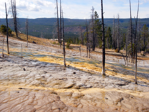
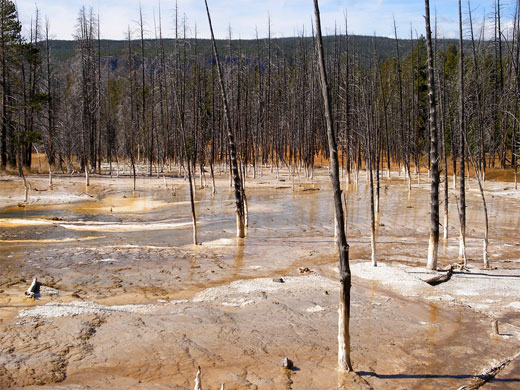
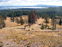
Even when Solitary Geyser is not erupting the scene is pretty, especially on the downhill side of the pool (north), where the run-off waters form a large region of terraces and streaked deposits, colored yellow, orange and brown by cyanobacteria, and studded with numerous dead, bleached white tree trunks. This area can be seen via a fainter path going around the north edge of the geyser and downhill a short distance. The main trail next has a short descent back to the valley floor, joining a branch of the Upper Geyser Basin boardwalk near Aurum Geyser.
Some parts of the route are a little steep but most is quite easy, and passes through a mixture of new growth pine woodland (after the 1988 wildfires) and surviving old forest; the loop takes around half an hour, not counting time spent waiting for the geyser to erupt.
Observation Point
Parking for the hike is at Old Faithful Village. The trail begins just north of Old Faithful itself, crosses the Firehole River and very soon reaches a junction with the much longer route to Mallard Lake, after which the path enters the fire-damaged forest, staying level at first then climbing slightly to a second junction. Turning right, a rather steeper ascent reaches Observation Point, about 200 feet above and a third of a mile distant from Old Faithful. The valley below is somewhat obscured by trees but all of Old Faithful Village is in full view, as is the next set of geysers to the north (Geyser Hill). This place is a good alternative location from which to watch an Old Faithful eruption, as although much further away than the regular viewing platform, the overlook gives a better sense of scale and perspective.
Solitary Geyser
The trail continues through thicker, unburnt forest of large trees that grow quite close together, making the surroundings cool and shady. The woodland opens out after half a mile at the viewing area beside the cloudy, turquoise pool of Solitary Geyser, enclosed in a delicate rim of creamy white sinter. The geyser usually erupts every six to ten minutes to heights of a few feet, but has only done so following construction of a diversion channel (in 1915) that used to take some water to a resort at the nearby village; prior to this the pool was merely a hot spring. Although the channel is long since removed, the change in behaviour persists.
Return Route
Even when Solitary Geyser is not erupting the scene is pretty, especially on the downhill side of the pool (north), where the run-off waters form a large region of terraces and streaked deposits, colored yellow, orange and brown by cyanobacteria, and studded with numerous dead, bleached white tree trunks. This area can be seen via a fainter path going around the north edge of the geyser and downhill a short distance. The main trail next has a short descent back to the valley floor, joining a branch of the Upper Geyser Basin boardwalk near Aurum Geyser.
Observation Point Trail - Similar Hikes
All Contents © Copyright The American Southwest | Comments and Questions | Contribute | Affiliate Marketing Disclosure | Site Map