Hackberry Canyon, Grand Staircase-Escalante National Monument
Utah > Grand Staircase-Escalante National Monument > Hackberry Canyon
Hackberry Canyon
The lower section of a long drainage, a tributary of Cottonwood Creek; forms a deep and narrow gorge through light-colored Navajo sandstone. Usually contains a shallow stream, flowing through pools and cascades, shaded by cottonwood trees; beautiful riparian canyon scenery
Length: 2 miles, to the upper end of the enclosed section
Elevation change: 120 feet
Difficulty: Easy, though shallow wading may be required
Type: One way
Usage: Low
Season: All year, but not during wet weather, as rain makes the access road impassable
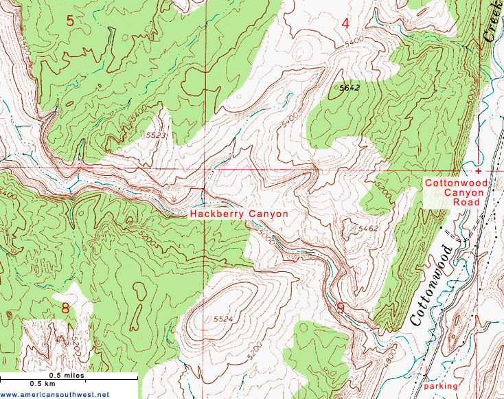
Trailhead: Along Cottonwood Canyon Road, 31 miles south of Cannonville, 14.4 miles north of US 89
Rating (1-5): ★★★★★
Elevation change: 120 feet
Difficulty: Easy, though shallow wading may be required
Type: One way
Usage: Low
Season: All year, but not during wet weather, as rain makes the access road impassable
Trailhead: Along Cottonwood Canyon Road, 31 miles south of Cannonville, 14.4 miles north of US 89
Rating (1-5): ★★★★★

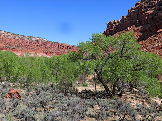
Hackberry Canyon is a long drainage, 17 miles, a tributary of Cottonwood Creek, joining it shortly before its confluence with the main watercourse in this area, the Paria River. Much is not especially scenic, bordered by low cliffs, with a wide, sandy floor, quite overgrown, containing a small stream, though along the way are several photogenic, slot-like side canyons, including Round Valley Draw, Booker Canyon and Stone Donkey Canyon.
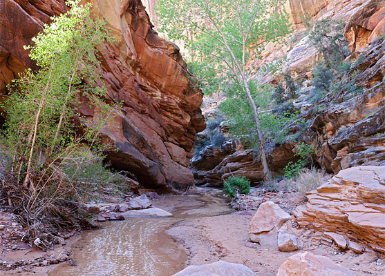
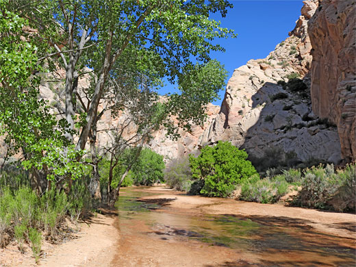
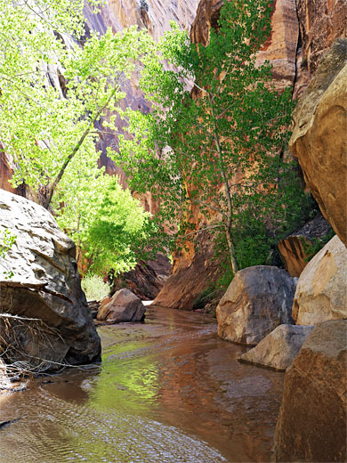
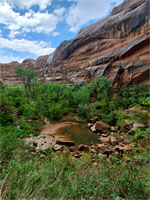
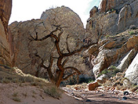
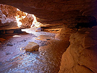
The drainage has no obstructions so all is suitable for hiking, however by far the most spectacular section is the lower 1.5 miles, cutting through a ridge of light-colored Navajo Sandstone. Here the creek is confined in a narrow gorge with vertical walls up to 300 feet high, the clear, gently trickling waters shaded by tall cottonwoods, flowing through pools and cascades, edged by wildflowers, and serenaded by the calls of canyon wrens, echoing down the passageways; the epitome of Southwest riparian canyon scenery.
The water of Hackberry Creek covers all of the canyon floor in some places but it is usually just a few inches deep, so a little wading is necessary, otherwise there are no difficulties, along a walk of 2 miles or so, until the canyon opens out abruptly at the far end of the Navajo sandstone layers, the canyon now bordered by low red cliffs of the Moenave and Kayenta formations. In midsummer all can be dry, however.
The Hackberry Canyon hike is provided with a marked trailhead, along Cottonwood Canyon Road, 14.4 miles from US 89 in the south and 31 miles from Cannonville in the north. The road is usually accessible to all vehicles including small RVs, though not if wet, as then it becomes impassable due to areas of soft clay.
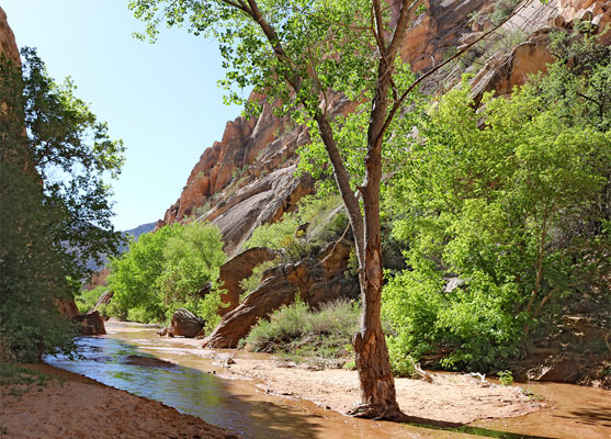
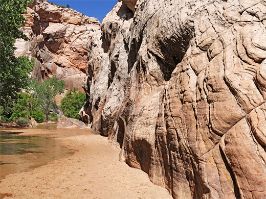
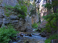
At the trailhead are two parking areas, either side of the road. A sign indicates a camping is not allowed here but there are various places for this nearby. The trail descends a slope to the streambed of Cottonwood Creek, which parallels the road for 16 miles, flowing all year. True to its name, the stream is lined most of the way by mature cottonwood trees. After a short distance Hackberry Creek joins from the west, and ahead this crosses a short open area before cliffs rise up, initially the Page Sandstone (Thousand Pockets Tongue) and Carmel Formation (Judd Hollow Tongue), soon followed by the much more extensive Navajo sandstone. The canyon narrows, and stays deep and enclosed for over a mile; it has sheer walls and a flat floor, initially nearly all sand with some higher banks to one side or other and containing occasional cottonwood trees, all very pretty.
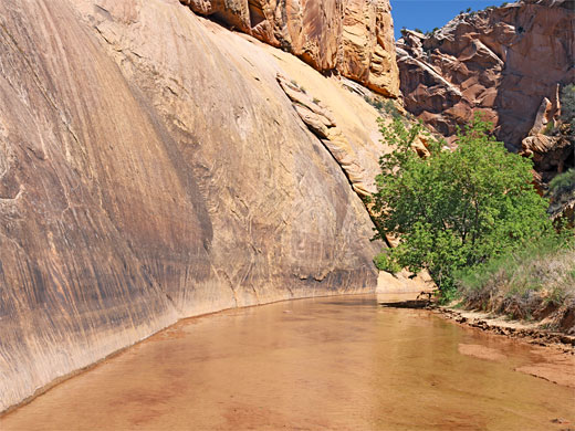
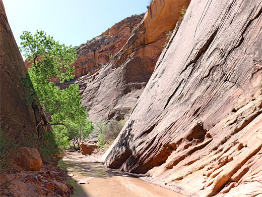
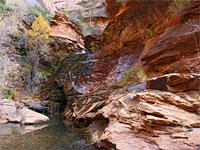
A little way past the middle of the gorge, the upwards gradient increases a little and Hackberry Canyon becomes more bouldery, the stream deeper in some places, flowing over cascades and between large fallen rocks. One narrow section is flanked by cliffs of inclined, thin-layered strata, partly overhanging, not far after which the canyon walls recede and the gorge widens. A fence and gate marks the downstream limit of cattle, who graze the canyon for many miles ahead. The bedrock changes from white Navajo Sandstone to red Moenave Formation, and soon the stream is winding gently through flat grassland with many trees and bushes; the views now extend a long way ahead. The water is nearly always clear, unlike the Paria River which is always cloudy, filled with clayish sediment.
The drainage has no obstructions so all is suitable for hiking, however by far the most spectacular section is the lower 1.5 miles, cutting through a ridge of light-colored Navajo Sandstone. Here the creek is confined in a narrow gorge with vertical walls up to 300 feet high, the clear, gently trickling waters shaded by tall cottonwoods, flowing through pools and cascades, edged by wildflowers, and serenaded by the calls of canyon wrens, echoing down the passageways; the epitome of Southwest riparian canyon scenery.
The water of Hackberry Creek covers all of the canyon floor in some places but it is usually just a few inches deep, so a little wading is necessary, otherwise there are no difficulties, along a walk of 2 miles or so, until the canyon opens out abruptly at the far end of the Navajo sandstone layers, the canyon now bordered by low red cliffs of the Moenave and Kayenta formations. In midsummer all can be dry, however.
The Hackberry Canyon hike is provided with a marked trailhead, along Cottonwood Canyon Road, 14.4 miles from US 89 in the south and 31 miles from Cannonville in the north. The road is usually accessible to all vehicles including small RVs, though not if wet, as then it becomes impassable due to areas of soft clay.
Hackberry Canyon Narrows
At the trailhead are two parking areas, either side of the road. A sign indicates a camping is not allowed here but there are various places for this nearby. The trail descends a slope to the streambed of Cottonwood Creek, which parallels the road for 16 miles, flowing all year. True to its name, the stream is lined most of the way by mature cottonwood trees. After a short distance Hackberry Creek joins from the west, and ahead this crosses a short open area before cliffs rise up, initially the Page Sandstone (Thousand Pockets Tongue) and Carmel Formation (Judd Hollow Tongue), soon followed by the much more extensive Navajo sandstone. The canyon narrows, and stays deep and enclosed for over a mile; it has sheer walls and a flat floor, initially nearly all sand with some higher banks to one side or other and containing occasional cottonwood trees, all very pretty.
The Wider Canyon
A little way past the middle of the gorge, the upwards gradient increases a little and Hackberry Canyon becomes more bouldery, the stream deeper in some places, flowing over cascades and between large fallen rocks. One narrow section is flanked by cliffs of inclined, thin-layered strata, partly overhanging, not far after which the canyon walls recede and the gorge widens. A fence and gate marks the downstream limit of cattle, who graze the canyon for many miles ahead. The bedrock changes from white Navajo Sandstone to red Moenave Formation, and soon the stream is winding gently through flat grassland with many trees and bushes; the views now extend a long way ahead. The water is nearly always clear, unlike the Paria River which is always cloudy, filled with clayish sediment.
Topo Map of Hackberry Canyon
Hackberry Canyon - Similar Hikes
All Contents © Copyright The American Southwest | Comments and Questions | Contribute | Affiliate Marketing Disclosure | Site Map