Bridalveil Fall Trail, Yosemite National Park
California > Yosemite National Park > Yosemite Valley > Hiking > Bridalveil Fall Trail
Bridalveil Fall Trail
Short hike on a paved path to a viewing area near the base of a huge waterfall, most spectacular in late spring but sometimes almost dry by late summer. In drier conditions it is possible to scramble over boulders, closer to the cascade
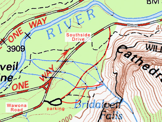
Length: 0.15 miles from Wawona Road or 0.3 miles from Southside Drive
Elevation change: 80 feet
Difficulty: Easy
Type: One way
Usage: High
Season: All year
Trailhead: Parking place along Wawona Road
Rating (1-5): ★★★★★
Elevation change: 80 feet
Difficulty: Easy
Type: One way
Usage: High
Season: All year
Trailhead: Parking place along Wawona Road
Rating (1-5): ★★★★★

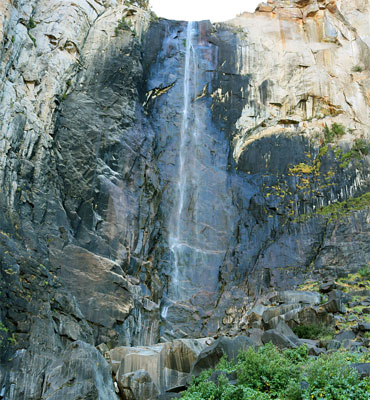
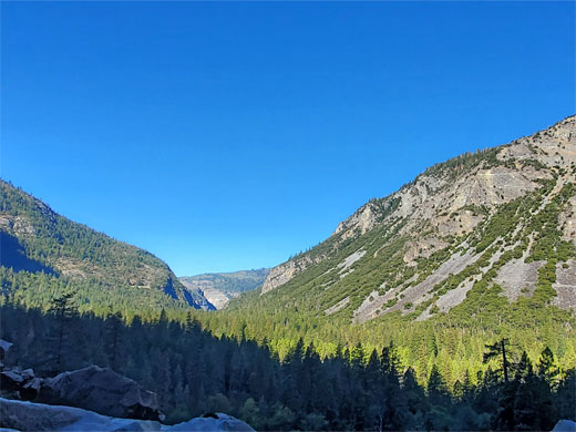
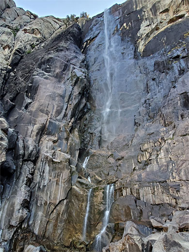
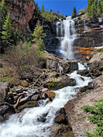
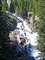
Bridalveil Fall is the first major waterfall seen by visitors to Yosemite Valley; on the south side, 2 miles east of Tunnel View, where the waters of Bridalveil Creek drop 620 feet over a sheer granite cliff, flanked by the peaks of Cathedral Rocks and Leaning Tower. Like all waterfalls in Yosemite the flow varies greatly over the year, as the falls are by far the most spectacular during the snowmelt season of late spring, but they may be almost dry by late summer.
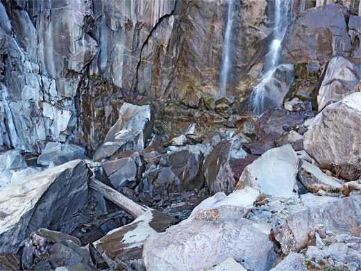
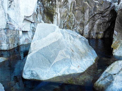
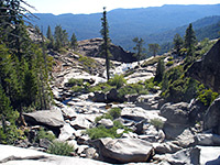
The viewing area at the base of the waterfall is reached by a popular and often very busy trail, starting either along Wawona Road, a paved route of just 800 feet, of from roadside parking along Southside Drive, a 0.3 three mile path, partly paved. The viewpoint is around 500 feet from the actual fall and 250 feet below, separated by a field of huge boulders along the creek, which can be traversed for a closer and better perspective, though this is not advisable at times of high flow as the rocks are extremely slippery and often partially obscured by spray. In summer though most of the boulders are dry and the extended hike is relatively straightforward.
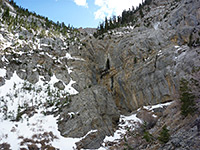
Bridalveil Creek originates at Ostrander Lake, 8,505 feet, and flows northwest, past Bridalveil campground along Glacier Point Road, then down a steep-sided canyon to the brink of the waterfall, at 4,800 feet. The falls are in shadow much of the day, illuminated only in late afternoon, and are only visible from a few miles of Yosemite Valley, at its west end, being hidden by the Cathedral Rocks from places further east.
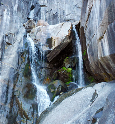
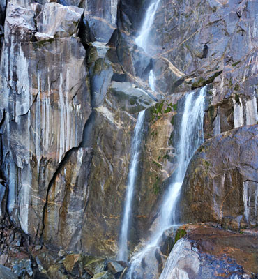
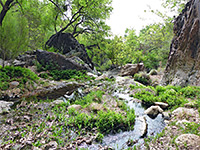
Most people hike to Bridalveil Fall from the large parking lot at the lower end of Wawona Road, just before the junction with Southside Drive. This has a phone, restrooms, information boards and maps. The wide, paved trail leads through the pine woods, soon reaching a junction, right being to the viewpoint; this climbs gently, passing an intermediate, accessible vantage point of the falls, since the last part of the route (300 feet) although still paved, is considered too steep for wheelchairs. At the end of the path is a walled enclosure, often with several dozen people here. A faint, unofficial path shows the start of the route up to the actual fall, though this soon disappears amongst the boulders. It takes about five minutes to climb to the lowest section of the cascade, with pools and a split waterfall, then about the same to ascend higher, curving round a basin, to the base of the main falls, surrounded by stark gray rocks and dark water pools, with absolutely no vegetation.
Half way down the spur trail to the falls, near the accessible viewpoint, is a junction with a less-used path to the south, providing an alternative way back to the Wawona Road trailhead, running closer to the cliffs, while from the initial junction, the Bridalveil Fall Trail stays paved for a short distance, up to a bridge over Bridalveil Creek, then is unpaved for the final 800 feet to the eastern terminus, along Southside Drive.
The viewing area at the base of the waterfall is reached by a popular and often very busy trail, starting either along Wawona Road, a paved route of just 800 feet, of from roadside parking along Southside Drive, a 0.3 three mile path, partly paved. The viewpoint is around 500 feet from the actual fall and 250 feet below, separated by a field of huge boulders along the creek, which can be traversed for a closer and better perspective, though this is not advisable at times of high flow as the rocks are extremely slippery and often partially obscured by spray. In summer though most of the boulders are dry and the extended hike is relatively straightforward.
Bridalveil Creek originates at Ostrander Lake, 8,505 feet, and flows northwest, past Bridalveil campground along Glacier Point Road, then down a steep-sided canyon to the brink of the waterfall, at 4,800 feet. The falls are in shadow much of the day, illuminated only in late afternoon, and are only visible from a few miles of Yosemite Valley, at its west end, being hidden by the Cathedral Rocks from places further east.
The Falls
Most people hike to Bridalveil Fall from the large parking lot at the lower end of Wawona Road, just before the junction with Southside Drive. This has a phone, restrooms, information boards and maps. The wide, paved trail leads through the pine woods, soon reaching a junction, right being to the viewpoint; this climbs gently, passing an intermediate, accessible vantage point of the falls, since the last part of the route (300 feet) although still paved, is considered too steep for wheelchairs. At the end of the path is a walled enclosure, often with several dozen people here. A faint, unofficial path shows the start of the route up to the actual fall, though this soon disappears amongst the boulders. It takes about five minutes to climb to the lowest section of the cascade, with pools and a split waterfall, then about the same to ascend higher, curving round a basin, to the base of the main falls, surrounded by stark gray rocks and dark water pools, with absolutely no vegetation.
Other Trails
Half way down the spur trail to the falls, near the accessible viewpoint, is a junction with a less-used path to the south, providing an alternative way back to the Wawona Road trailhead, running closer to the cliffs, while from the initial junction, the Bridalveil Fall Trail stays paved for a short distance, up to a bridge over Bridalveil Creek, then is unpaved for the final 800 feet to the eastern terminus, along Southside Drive.
Map of the Bridalveil Fall Trail
Bridalveil Fall Trail - Similar Hikes
All Contents © Copyright The American Southwest | Comments and Questions | Contribute | Affiliate Marketing Disclosure | Site Map