Bear Creek Trail, Telluride, San Juan Mountains
Colorado > San Juan Mountains > Bear Creek Trail, Telluride
Bear Creek
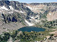
Wooded valley with meadows and many wildflowers, on the south side of Telluride, leading to a spectacular waterfall, ringed by colorful cliffs
Length: 2.4 miles, plus 0.6 miles to reach the trailhead
Elevation change: 1,000 feet
Difficulty: Moderate
Type: One way
Usage: High
Season: Spring, summer, fall
Trailhead: South end of Pine Street, in Telluride
Rating (1-5): ★★★★★
Elevation change: 1,000 feet
Difficulty: Moderate
Type: One way
Usage: High
Season: Spring, summer, fall
Trailhead: South end of Pine Street, in Telluride
Rating (1-5): ★★★★★

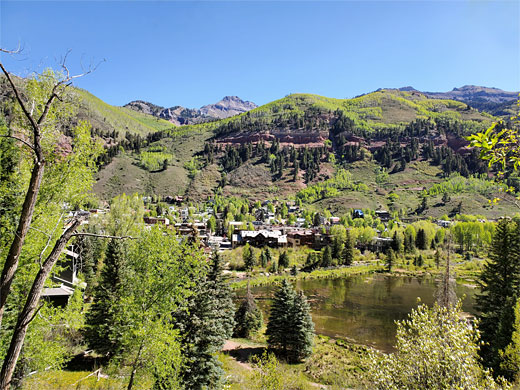
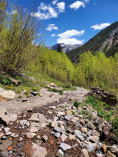
The 2.4 mile trail to Bear Creek Falls is by some distance the most popular trail near Telluride, in the western San Juan Mountains, since it is not too long but still provides a moderate challenge, passes a good variety of scenery - views over the town, a verdant mix of pine/aspen woodland, and meadows with many wildflowers - and ends beside a spectacular waterfall ringed by colorful, red/brown rocks. The only downside is that the path can get very busy and, like all trails that start in town, there is no parking at the trailhead. The route is usually accessible all year, though winter snowfall can make the trip rather difficult on occasions.
All of the Bear Creek Trail is along what was once a vehicle track, an old mining road, so is wide and has no especially steep parts; it rises gently from the town along the side of the main valley then turns away up the Bear Creek tributary, climbing through gradually more open terrain, ending just below the waterfall.
The hike is entirely within the 381-acre Bear Creek Preserve, which was created in 1995 by purchase of the land by the San Miguel Conservation Foundation. The trail is all on the west side of the creek, the majority some way above the streambed due to the steep sides. A partial loop can be made by crossing to the east about three quarters of the way to the falls, returning via a narrower trail that bridges the stream again at the edge of Telluride.
San Juan Mountains area map, Bear Creek topographic map.
24 views along the Bear Creek Trail.
The Bear Creek trailhead is at the south end of Pine Street, a few blocks from the town center. On-street parking in Telluride is very limited, generally for residents only; visitors are advised to use the (free) Carhenge parking lot at the west edge of town, just south of the San Miguel River. From here it is 0.6 miles to the start of the trail; over the road bridge to the parking then along a riverside path, past a collection of attractive rustic houses, all shaded by ancient pine trees. The path leads under the cable lines of the Gondola, a cable line linking Telluride with Mountain Village, 2 miles west, a 12 minute ride for which there is no charge - the only example of a free gondola in the country. Just past the cables, the path returns to the south bank of the river and meets Pine Street; the waterfall trail starts 140 feet south.
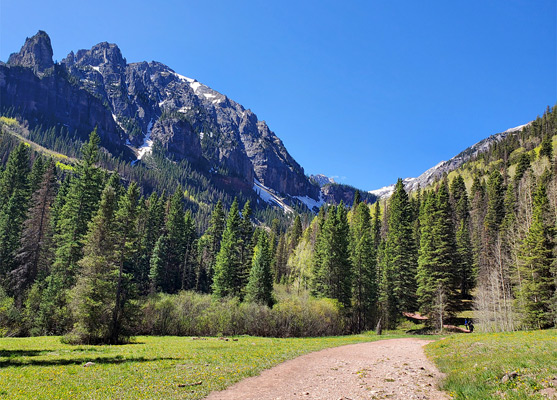
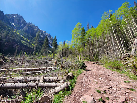
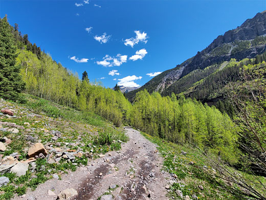
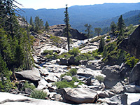
The wide gravel track ascends the hillside through dense aspen woodland with plenty of wildflowers along the edge, most noticeably the western red columbine. It soon passes a connecting path on the left (part of the optional loop) then, after half a mile, reaches the mouth of Bear Creek Canyon, marked by a noticeboard and map, and another link path from below. The track then curves round to the south, following the valley upstream, always a little way above the creek, often within earshot of it but mostly out of sight. The upwards gradient is steady but never to steep. Gaps in the trees allow fleeting views of the mountains at either side, which are especially dramatic to the east, and a few tiny streams cross the trail, mostly dry by early summer. Roughfruit fairybells and black twinberry are two of the more unusual wildflowers along the wooded sections of the path.
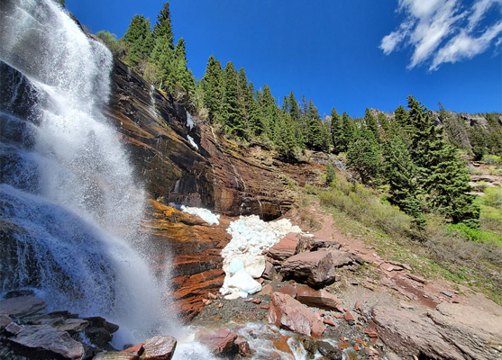
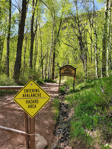
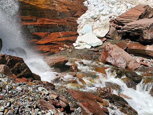
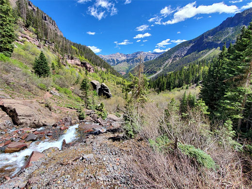
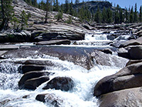
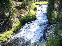
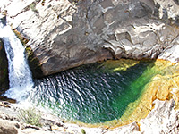
The woodland starts to thin out, the tress now mostly conifers, alternating with patches of grassland, followed by a larger meadow, close to the stream. Not far beyond, after an area of avalanche-damaged trees, is another meadow, from where a path forks off to the east, crossing the creek - this is the optional loop. Another wooded section needs to a junction, where the Wasatch Trail departs to the southwest, accessing the upper end of the valley and continuing to a pass on San Juan Mountain crest. The Bear Creek Trail becomes a little rockier, winding through bushy terrain, up to a huge boulder, from which the first good view of the falls is obtained,. The last section rises through jumbled rocks to the base of the 80 foot cascade, flanked red and grey cliffs of shale and sandstone (from the Cutler Formation), on sunny days embellished by transient rainbows from the spray.
All of the Bear Creek Trail is along what was once a vehicle track, an old mining road, so is wide and has no especially steep parts; it rises gently from the town along the side of the main valley then turns away up the Bear Creek tributary, climbing through gradually more open terrain, ending just below the waterfall.
The hike is entirely within the 381-acre Bear Creek Preserve, which was created in 1995 by purchase of the land by the San Miguel Conservation Foundation. The trail is all on the west side of the creek, the majority some way above the streambed due to the steep sides. A partial loop can be made by crossing to the east about three quarters of the way to the falls, returning via a narrower trail that bridges the stream again at the edge of Telluride.

Location
San Juan Mountains area map, Bear Creek topographic map.
Photographs
24 views along the Bear Creek Trail.
Bear Creek Video
Bear Creek Trailhead
The Bear Creek trailhead is at the south end of Pine Street, a few blocks from the town center. On-street parking in Telluride is very limited, generally for residents only; visitors are advised to use the (free) Carhenge parking lot at the west edge of town, just south of the San Miguel River. From here it is 0.6 miles to the start of the trail; over the road bridge to the parking then along a riverside path, past a collection of attractive rustic houses, all shaded by ancient pine trees. The path leads under the cable lines of the Gondola, a cable line linking Telluride with Mountain Village, 2 miles west, a 12 minute ride for which there is no charge - the only example of a free gondola in the country. Just past the cables, the path returns to the south bank of the river and meets Pine Street; the waterfall trail starts 140 feet south.
The Valley
The wide gravel track ascends the hillside through dense aspen woodland with plenty of wildflowers along the edge, most noticeably the western red columbine. It soon passes a connecting path on the left (part of the optional loop) then, after half a mile, reaches the mouth of Bear Creek Canyon, marked by a noticeboard and map, and another link path from below. The track then curves round to the south, following the valley upstream, always a little way above the creek, often within earshot of it but mostly out of sight. The upwards gradient is steady but never to steep. Gaps in the trees allow fleeting views of the mountains at either side, which are especially dramatic to the east, and a few tiny streams cross the trail, mostly dry by early summer. Roughfruit fairybells and black twinberry are two of the more unusual wildflowers along the wooded sections of the path.
The Waterfall
The woodland starts to thin out, the tress now mostly conifers, alternating with patches of grassland, followed by a larger meadow, close to the stream. Not far beyond, after an area of avalanche-damaged trees, is another meadow, from where a path forks off to the east, crossing the creek - this is the optional loop. Another wooded section needs to a junction, where the Wasatch Trail departs to the southwest, accessing the upper end of the valley and continuing to a pass on San Juan Mountain crest. The Bear Creek Trail becomes a little rockier, winding through bushy terrain, up to a huge boulder, from which the first good view of the falls is obtained,. The last section rises through jumbled rocks to the base of the 80 foot cascade, flanked red and grey cliffs of shale and sandstone (from the Cutler Formation), on sunny days embellished by transient rainbows from the spray.
Bear Creek Wildflowers
More flowers along the trail
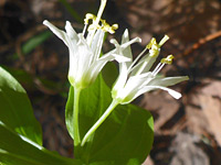 Roughfruit fairybells |
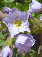 Showy jacob's ladder |
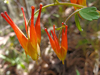 Western red columbine |
More flowers along the trail
Bear Creek Trail - Similar Hikes
All Contents © Copyright The American Southwest | Comments and Questions | Contribute | Affiliate Marketing Disclosure | Site Map