Owl Canyon, Rainbow Basin National Natural Landmark
California > Rainbow Basin National Natural Landmark > Owl Canyon
Owl Canyon
Winding, generally shallow ravine, alternating between open and enclosed, through multicolored strata, past photogenic rock formations including hoodoos, caves and arches. Many wildflowers in the spring
Length: 2 mile, to the basin at the upper end of the drainage
Elevation change: 500 feet
Difficulty: Easy to moderate
Type: One-way, mostly off-trail
Usage: Low
Season: All year, though very hot in summer
Trailhead: Parking area at the end of Owl Canyon Road
Rating (1-5): ★★★★★
Elevation change: 500 feet
Difficulty: Easy to moderate
Type: One-way, mostly off-trail
Usage: Low
Season: All year, though very hot in summer
Trailhead: Parking area at the end of Owl Canyon Road
Rating (1-5): ★★★★★

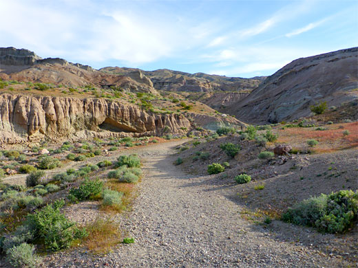
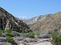
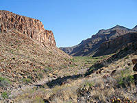
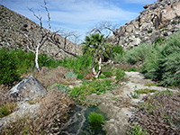
Owl Canyon is the largest of several drainages in Rainbow Basin Natural Area, or Area of Critical Environmental Concern (ACEC), in the Mud Hills, in the Mojave Desert ten miles north of Barstow. Dry for most of the year, apart from a small spring at one point, the canyon alternates between enclosed channels and more open sections, and cuts through contrasting rock layers, of shale, conglomerate, breccia and granite, in a range of pastel color shades, similar to the central portion of the basin to the west, the area followed by the scenic drive.
The canyon is the main hiking destination in the ACEC, starting from a BLM trailhead at the north end of the road to the Owl Canyon campground. A trail extends a little way then the majority of the hike is all along the streambed, over few minor obstacles, past a great array of eroded rock formations, for about 2 miles, until the drainage enters a wide basin and splits into several minor tributaries.
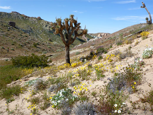
Joshua trees grow here, together with several cactus species including the rare Mojave fishhook cactus, while all along the wash are a good variety of wildflowers. Lizards, snakes and the desert tortoise are amongst the wildlife that may be seen.
The track to Owl Canyon forks off the scenic loop to Rainbow Basin, just before the start of its one-way section. It passes a group camp then crosses the streambed and continues a short distance to the main campground; this has 22 non-hookup sites, equipped with picnic tables and fire rings. Drinking water is usually available, while free primitive camping is possible along other tracks in the vicinity. The surroundings are low, dusty, gray-brown hills, composed of lacustrine clay shale, the strata banded and inclined.
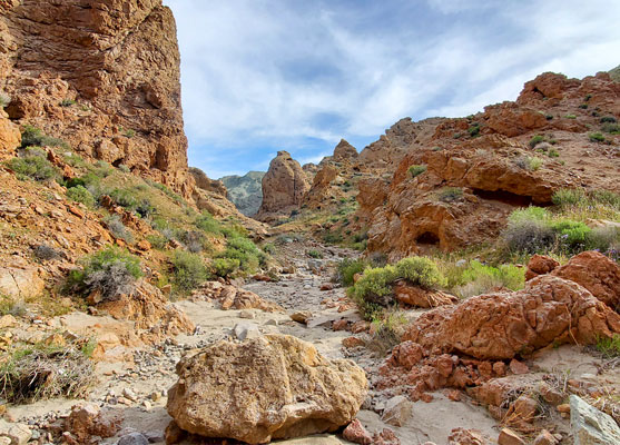
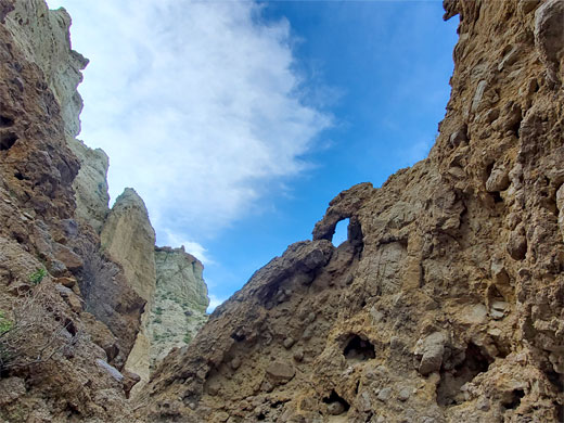
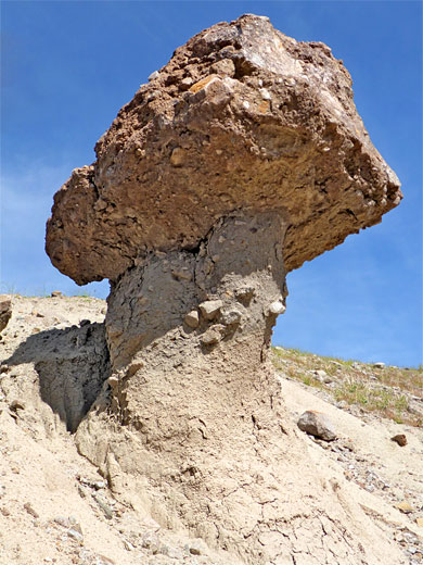
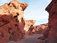
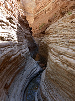
From the trailhead, the signed path runs along a bench on the east side of the drainage for a short distance then drops down into the wash, which twists and turns, the rocks greenish gray at this point. The drainage is initially not confined but soon enters a section of narrows where the rock changes to knobbly gray strata from the Owl Conglomerate - this streambed now running between vertical cliffs, with many pebbles and boulders on the floor. Just before is an east-side tributary that forms a short cave, almost completely dark in the middle. The main canyon has a couple of dryfalls, not difficult to pass, followed by a longer, straight enclosed passage, leading to the next open area. The rocks now are red, still conglomerate, but soon change again, to light-colored breccia, from the Pickhandle Formation.
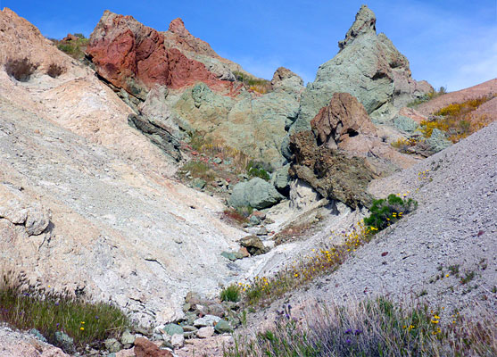
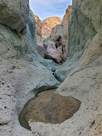
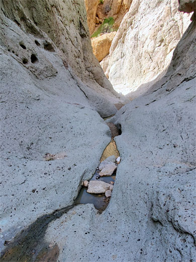
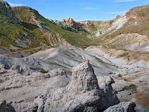
Next are some photogenic narrow sections through the volcanic rocks, usually holding a short line of spring-fed pools. All around are smooth slickrock slopes, white, greenish or pale red, dotted with colorful wildflowers in the spring. Another dryfall is followed by a few hundred feet of bouldery passageways, gaining height a little more steeply, the rocks generally green or grey, becoming multi-colored once more as the streambed divides into several shallow tributaries, this in the basin that marks the end of the hike. At the center are a group of eroded breccia pinnacles, while the sides are grassy, gently sloping, dotted with Joshua trees and cacti - cholla and beavertail, plus the occasional fishhook cactus. There are several ATV tracks across the upper reaches of the basin, accessed from the north, off Copper City Road.
The canyon is the main hiking destination in the ACEC, starting from a BLM trailhead at the north end of the road to the Owl Canyon campground. A trail extends a little way then the majority of the hike is all along the streambed, over few minor obstacles, past a great array of eroded rock formations, for about 2 miles, until the drainage enters a wide basin and splits into several minor tributaries.
Joshua trees grow here, together with several cactus species including the rare Mojave fishhook cactus, while all along the wash are a good variety of wildflowers. Lizards, snakes and the desert tortoise are amongst the wildlife that may be seen.
Approach
The track to Owl Canyon forks off the scenic loop to Rainbow Basin, just before the start of its one-way section. It passes a group camp then crosses the streambed and continues a short distance to the main campground; this has 22 non-hookup sites, equipped with picnic tables and fire rings. Drinking water is usually available, while free primitive camping is possible along other tracks in the vicinity. The surroundings are low, dusty, gray-brown hills, composed of lacustrine clay shale, the strata banded and inclined.
Conglomerate Narrows and a Cave
From the trailhead, the signed path runs along a bench on the east side of the drainage for a short distance then drops down into the wash, which twists and turns, the rocks greenish gray at this point. The drainage is initially not confined but soon enters a section of narrows where the rock changes to knobbly gray strata from the Owl Conglomerate - this streambed now running between vertical cliffs, with many pebbles and boulders on the floor. Just before is an east-side tributary that forms a short cave, almost completely dark in the middle. The main canyon has a couple of dryfalls, not difficult to pass, followed by a longer, straight enclosed passage, leading to the next open area. The rocks now are red, still conglomerate, but soon change again, to light-colored breccia, from the Pickhandle Formation.
Upper Owl Canyon
Next are some photogenic narrow sections through the volcanic rocks, usually holding a short line of spring-fed pools. All around are smooth slickrock slopes, white, greenish or pale red, dotted with colorful wildflowers in the spring. Another dryfall is followed by a few hundred feet of bouldery passageways, gaining height a little more steeply, the rocks generally green or grey, becoming multi-colored once more as the streambed divides into several shallow tributaries, this in the basin that marks the end of the hike. At the center are a group of eroded breccia pinnacles, while the sides are grassy, gently sloping, dotted with Joshua trees and cacti - cholla and beavertail, plus the occasional fishhook cactus. There are several ATV tracks across the upper reaches of the basin, accessed from the north, off Copper City Road.
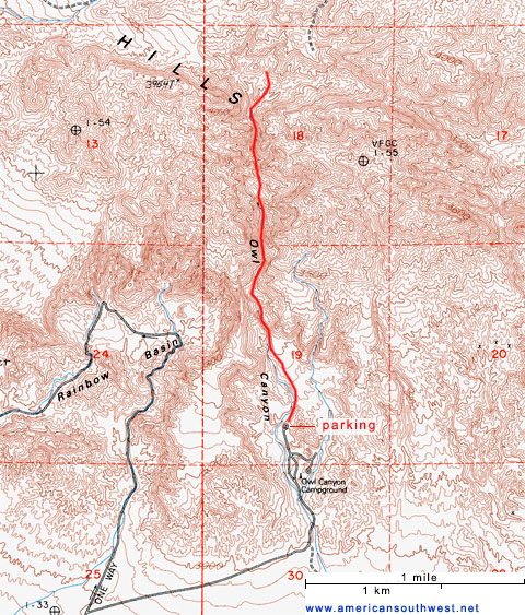
Topo Map of Owl Canyon
Owl Canyon Wildflowers
More flowers in the canyon
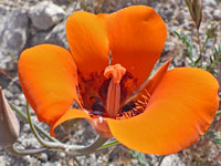 Desert mariposa lily |
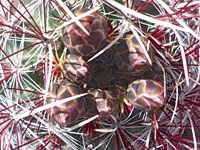 Mojave fishhook cactus |
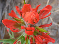 Desert paintbrush |
More flowers in the canyon
Owl Canyon - Similar Hikes
All Contents © Copyright The American Southwest | Comments and Questions | Contribute | Affiliate Marketing Disclosure | Site Map