Alamere Falls and Wildcat Beach, Point Reyes National Seashore
California > Point Reyes National Seashore > Hiking > Alamere Falls and Wildcat Beach
Alamere Falls and Wildcat Beach
Varied destinations along the southern section of the Coast Trail: several freshwater lakes, an unusual shoreline waterfall and a long sandy beach. The path alternates between grassy bluffs and thick woodland, generally staying some way above the ocean
Length: 2.8 miles to Bass Lake, 4.1 miles to Alamere Falls, 5.5 miles to Wildcat Beach
Elevation change: Relatively level
Difficulty: Easy to moderate, depending on the distance
Type: One way, or partial loop
Usage: High to the falls, medium to low thereafter
Season: All year
Trailhead: Palomarin, at the end of Mesa Road from Bolinas
Rating (1-5): ★★★★★
Elevation change: Relatively level
Difficulty: Easy to moderate, depending on the distance
Type: One way, or partial loop
Usage: High to the falls, medium to low thereafter
Season: All year
Trailhead: Palomarin, at the end of Mesa Road from Bolinas
Rating (1-5): ★★★★★

The Coast Trail in Point Reyes National Seashore extends for 16.5 miles along the southern edge of the Point Reyes peninsula, from the Palomarin trailhead near Bolinas, northwards to a spur off Limantour Road. The northernmost 1.5 miles is inland, along a marshy valley, but the majority is right beside or at least close to the ocean, albeit usually several hundred feet above the shoreline since cliffs and steep slopes restrict access to the narrow beaches below.
There are a number of the routes down, however, and for most of the trail, walking directly along the beach is possible, hence allowing partial loop hikes. Further adding to the hiking possibilities are ten intersecting paths, accessed from inland trailheads, the majority starting either at Bear Valley or Five Brooks.
Backpacking is required to see all the Coast Trail, though most people explore parts on day hikes, and the most popular destination is Alamere Falls, starting at the southern trailhead, Palomarin. The falls are a rare example of a coastal waterfall, although the waters do not drop directly into the ocean (like, at high tide, McWay Falls in Julia Pfeiffer Burns State Park), instead flowing down the cliffs just above the high water mark. They are accessed by a 0.4 mile spur path, the last section of which descends rather steeply down the cliffs.
The journey to the junction is mostly through dense woodland, past two freshwater lakes where the path veers inland for 2 miles; the first (Bass Lake) is popular for swimming. Beyond the spur to the falls, the trail continues alongside two smaller lakes to a primitive campsite adjoining Wildcat Beach; the hike described below is on the trail to this point, south along the beach to the falls, up the spur path then back to Palomarin.
Point Reyes National Seashore map, topographic map.
22 views along the trail.
The Palomarin trailhead lies along Mesa Road, starting in the small coastal town of Bolinas - a bumpy, winding route that enters the national seashore, passes a US Coast Guard installation and a bird sanctuary, and ends at a large parking area. The last mile is unpaved. Although spacious, parking soon fills up on busy days and vehicles have to be left up to a quarter of a mile back along verges. A 0.6 mile path descends 250 feet to the adjacent Palomarin Beach - mostly narrow and stony, bordered by crumbling soil and rock slopes - but the vast majority of people are here to visit Alamere Falls, the remainder heading further north along the Coast Trail.
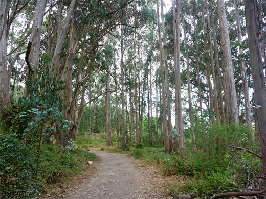
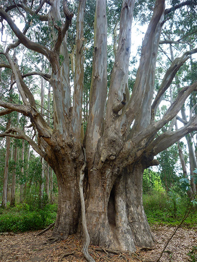
The Coast Trail, formerly a vehicle track, is wide, and level overall, with just a few brief steeper sections in and out of ravines. It starts beside a sign marking the boundary of the Phillip Burton Wilderness Area, crosses a small grove of non-native eucalyptus trees either side of a minor drainage, then exits the woodland, moving close to the ocean, and for nearly a mile runs along open, grassy bluffs, which give grand views out to sea and south over Bolinas Bay. Wildflowers are plentiful, most abundant being orange sticky monkey flower and blue dune lupine. Next is a small ravine, a junction with a short, unofficial path down to the water, and a second, larger ravine where the path curves inland and briefly back towards the coast before heading away again at the start of the 2 mile section where the ocean is out of sight; the diversion is necessary to avoid two lakes and their steep-sided, overgrown exit streams.
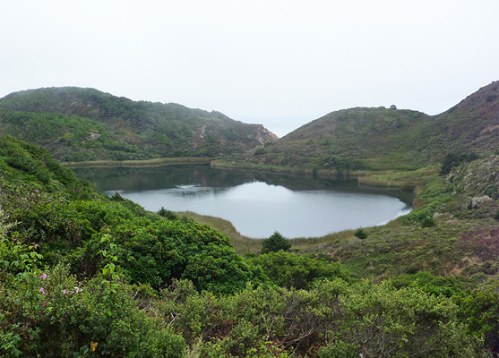
The path proceeds up the far side of the valley, across a small rock slide and along an upper branch of the ravine, northwards through the forest to a saddle, just before a junction with the Lake Ranch Trail, one of the ten connecting paths along the Coast Trail. Beyond here, the route is wide, flat and level, still through thick forest, coming close to several shallow ponds to the west. A stream flows beside the path a little way, leading to Bass Lake, which soon comes into view, 40 feet below the trail, beyond a band of trees and bushes. Another tiny creek crosses the path, forming a little waterfall and pool, marked with a notice advising of non-potable water. A spur leads to a shoreline access point on the northwest side of the lake, while the Coast Trail continues across an open area and into, airy, ferny woods containing occasional orchid flowers, to another junction, with the Crystal Lake Trail, now unmaintained and little-traveled. The surroundings become less wooded above the second lake (Pelican), and the path moves back towards the ocean. An unsigned side path climbs a little to a minor summit on a promontory, then just after is the 0.4 mile spur to Alamere Falls, which is mostly through dense vegetation - a narrow corridor enclosed by branches - apart from near the end, where it approaches the stream above the falls.
The Coast Trail leads through a similarly dark 'tree tunnel' and across Alamere Creek to the next junction. The two branches rejoin in less than a mile; right is the Coast Trail while left is the Ocean Lake Trail, lower in elevation and closer to the coast, so this is preferred. Along here, the land ahead is properly visible for the first time, all along the edge of Drakes Bay to Point Reyes Lighthouse. Reed-filled Ocean Lake is passed on the right - this usually has only a small area of clear water in the middle of overgrown shallows, and is followed by a short but steep ascent to a ridgetop, overlooking the Wildcat Beach camping area to the north. The path curves inland, close to but out of sight of another lake, Wildcat, before rejoining the Coast Trail, from where the camp is a short distance further, reached after a gentle descent into the wide valley of Wildcat Creek. The camp is situated on the far side of the creek, on a little hill, and its limited facilities include restrooms and a horse trough. The path continues up the far side of the valley, rising steeply.
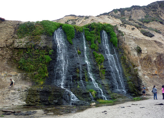
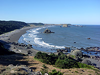
From the camp, a short walk alongside the stream leads to sandy Wildcat Beach, in the middle of a long, straight section of the coast where the ocean is bordered by sloping, crumbling cliffs of angled, thin-layered sandstone, the only other features being a few seeps where wildflowers grow, such as white greenspot nightshade, yellow field mustard and yellow monkeyflower. Much organic debris lines the high water mark. The beach is pleasant enough though not so scenic, and little changing along the 1.2 mile walk south, to Alamere Falls. This cascade is formed of several channels, falling about 50 feet over the cliffs, bordered by green vegetation, dropping into a little pool, from where the stream flows briefly north then west into the ocean. Several dozen people may be here at any one time during busy periods. The beach ends just beyond the falls, and protruding cliffs prevent walking any further south, even at low tide. The path up the cliffs beside the falls is steep and somewhat unstable, and while not difficult for experienced hikers, causes problems for some people. Just above the falls are several pools and smaller cascades, and the trail runs alongside for a few hundred feet before turning away into the thick, low vegetation, and meets the Coast Trail after 0.4 miles, from where the Palomarin trailhead is 3.7 miles south.
There are a number of the routes down, however, and for most of the trail, walking directly along the beach is possible, hence allowing partial loop hikes. Further adding to the hiking possibilities are ten intersecting paths, accessed from inland trailheads, the majority starting either at Bear Valley or Five Brooks.
Backpacking is required to see all the Coast Trail, though most people explore parts on day hikes, and the most popular destination is Alamere Falls, starting at the southern trailhead, Palomarin. The falls are a rare example of a coastal waterfall, although the waters do not drop directly into the ocean (like, at high tide, McWay Falls in Julia Pfeiffer Burns State Park), instead flowing down the cliffs just above the high water mark. They are accessed by a 0.4 mile spur path, the last section of which descends rather steeply down the cliffs.
The journey to the junction is mostly through dense woodland, past two freshwater lakes where the path veers inland for 2 miles; the first (Bass Lake) is popular for swimming. Beyond the spur to the falls, the trail continues alongside two smaller lakes to a primitive campsite adjoining Wildcat Beach; the hike described below is on the trail to this point, south along the beach to the falls, up the spur path then back to Palomarin.
Location
Point Reyes National Seashore map, topographic map.
Photographs
22 views along the trail.
Palomarin Trailhead
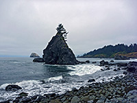
The Palomarin trailhead lies along Mesa Road, starting in the small coastal town of Bolinas - a bumpy, winding route that enters the national seashore, passes a US Coast Guard installation and a bird sanctuary, and ends at a large parking area. The last mile is unpaved. Although spacious, parking soon fills up on busy days and vehicles have to be left up to a quarter of a mile back along verges. A 0.6 mile path descends 250 feet to the adjacent Palomarin Beach - mostly narrow and stony, bordered by crumbling soil and rock slopes - but the vast majority of people are here to visit Alamere Falls, the remainder heading further north along the Coast Trail.
Start of the Coast Trail
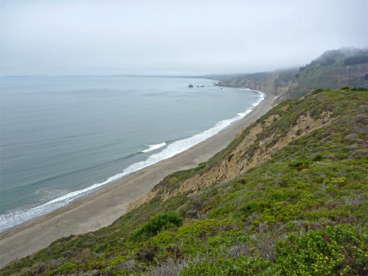
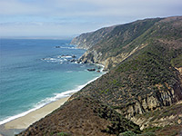
The Coast Trail, formerly a vehicle track, is wide, and level overall, with just a few brief steeper sections in and out of ravines. It starts beside a sign marking the boundary of the Phillip Burton Wilderness Area, crosses a small grove of non-native eucalyptus trees either side of a minor drainage, then exits the woodland, moving close to the ocean, and for nearly a mile runs along open, grassy bluffs, which give grand views out to sea and south over Bolinas Bay. Wildflowers are plentiful, most abundant being orange sticky monkey flower and blue dune lupine. Next is a small ravine, a junction with a short, unofficial path down to the water, and a second, larger ravine where the path curves inland and briefly back towards the coast before heading away again at the start of the 2 mile section where the ocean is out of sight; the diversion is necessary to avoid two lakes and their steep-sided, overgrown exit streams.
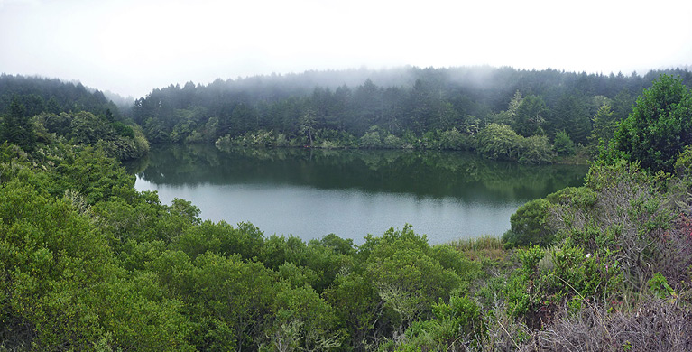
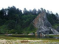
Bass Lake and Pelican Lake
The path proceeds up the far side of the valley, across a small rock slide and along an upper branch of the ravine, northwards through the forest to a saddle, just before a junction with the Lake Ranch Trail, one of the ten connecting paths along the Coast Trail. Beyond here, the route is wide, flat and level, still through thick forest, coming close to several shallow ponds to the west. A stream flows beside the path a little way, leading to Bass Lake, which soon comes into view, 40 feet below the trail, beyond a band of trees and bushes. Another tiny creek crosses the path, forming a little waterfall and pool, marked with a notice advising of non-potable water. A spur leads to a shoreline access point on the northwest side of the lake, while the Coast Trail continues across an open area and into, airy, ferny woods containing occasional orchid flowers, to another junction, with the Crystal Lake Trail, now unmaintained and little-traveled. The surroundings become less wooded above the second lake (Pelican), and the path moves back towards the ocean. An unsigned side path climbs a little to a minor summit on a promontory, then just after is the 0.4 mile spur to Alamere Falls, which is mostly through dense vegetation - a narrow corridor enclosed by branches - apart from near the end, where it approaches the stream above the falls.
Ocean Lake Trail
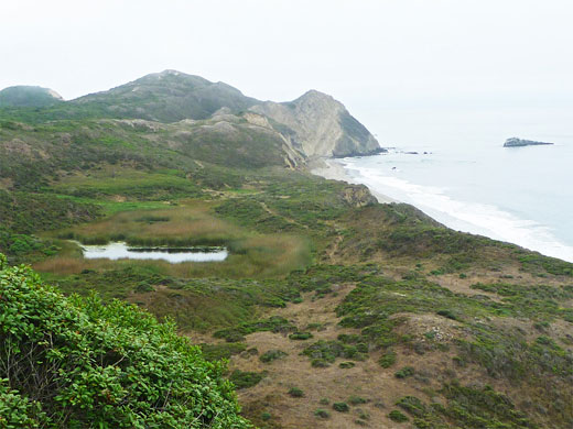
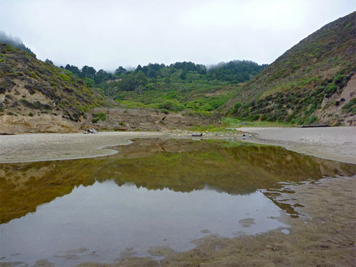
The Coast Trail leads through a similarly dark 'tree tunnel' and across Alamere Creek to the next junction. The two branches rejoin in less than a mile; right is the Coast Trail while left is the Ocean Lake Trail, lower in elevation and closer to the coast, so this is preferred. Along here, the land ahead is properly visible for the first time, all along the edge of Drakes Bay to Point Reyes Lighthouse. Reed-filled Ocean Lake is passed on the right - this usually has only a small area of clear water in the middle of overgrown shallows, and is followed by a short but steep ascent to a ridgetop, overlooking the Wildcat Beach camping area to the north. The path curves inland, close to but out of sight of another lake, Wildcat, before rejoining the Coast Trail, from where the camp is a short distance further, reached after a gentle descent into the wide valley of Wildcat Creek. The camp is situated on the far side of the creek, on a little hill, and its limited facilities include restrooms and a horse trough. The path continues up the far side of the valley, rising steeply.

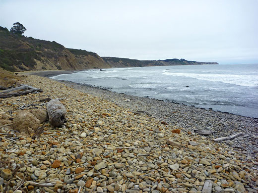
Wildcat Beach and Alamere Falls
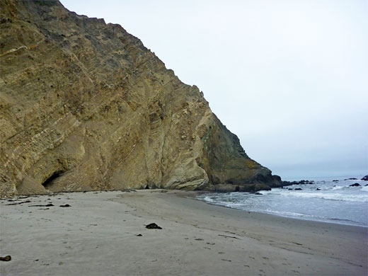
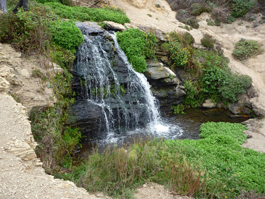
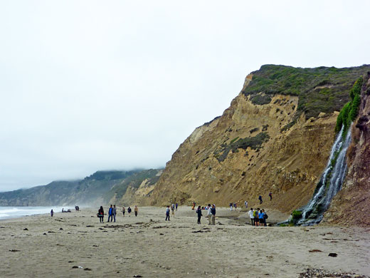
From the camp, a short walk alongside the stream leads to sandy Wildcat Beach, in the middle of a long, straight section of the coast where the ocean is bordered by sloping, crumbling cliffs of angled, thin-layered sandstone, the only other features being a few seeps where wildflowers grow, such as white greenspot nightshade, yellow field mustard and yellow monkeyflower. Much organic debris lines the high water mark. The beach is pleasant enough though not so scenic, and little changing along the 1.2 mile walk south, to Alamere Falls. This cascade is formed of several channels, falling about 50 feet over the cliffs, bordered by green vegetation, dropping into a little pool, from where the stream flows briefly north then west into the ocean. Several dozen people may be here at any one time during busy periods. The beach ends just beyond the falls, and protruding cliffs prevent walking any further south, even at low tide. The path up the cliffs beside the falls is steep and somewhat unstable, and while not difficult for experienced hikers, causes problems for some people. Just above the falls are several pools and smaller cascades, and the trail runs alongside for a few hundred feet before turning away into the thick, low vegetation, and meets the Coast Trail after 0.4 miles, from where the Palomarin trailhead is 3.7 miles south.
Coastal Trail Wildflowers
More flowers along the trail
 Ruby chalice fairyfan |
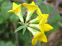 Narrow-leaf bird's-foot trefoil |
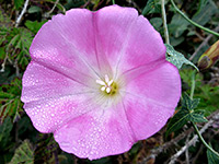 Pacific false bindweed |
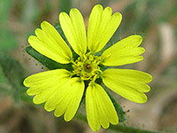 Coast tarweed |
More flowers along the trail
Alamere Falls and Wildcat Beach - Similar Hikes
All Contents © Copyright The American Southwest | Comments and Questions | Contribute | Affiliate Marketing Disclosure | Site Map