Hiking in Prairie Creek Redwoods State Park
California > Redwood National and State Parks > Prairie Creek Redwoods State Park > Hiking
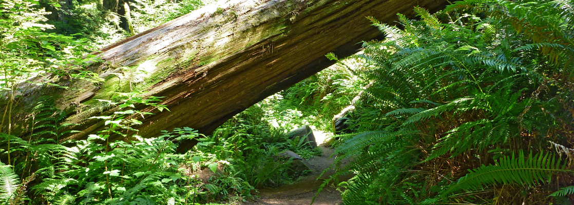
Pick of the shorter walks are along the Brown Creek, Cathedral Trees, Circle, Fern Canyon, Ossagon, Prairie Creek and Rhododendron (south section) trails, while the best extended hike is the loop along the James Irvine and Miners Ridge trails.
Elevation changes are generally minor, and the interconnecting paths allow for many loop hikes. Most routes start along the Newton B Drury Scenic Parkway, the main road through the center of the park.
The Prairie Creek Redwoods map shows the location of each trail.
See also hikes in Redwood National Park.

Prairie Creek Redwoods Trails
|
Ah-Pah Trail Length 0.3 miles (0.5 km) Elevation change 40 feet (12 meters) Trailhead Parking area along the Newton B Drury Scenic Parkway Rating (1-5) ★★★★★ This short interpretive trail follows the first section of an old logging road through the redwood forest, a track since removed and the surroundings changed back to a natural condition. Notices along the way illustrate the restorative process. |
|
Boat Creek Trail Length 1.7 miles (2.7 km) Elevation change 400 feet (122 meters) Trailhead Along the Friendship Ridge Trail Rating (1-5) ★★★★★ Branching off the Friendship Ridge Trail near its northern end, the Boat Creek Trail crosses densely-wooded hills bearing redwoods and spruce, running alongside a steep ravine south towards the Pacific. The official trail ends a little way before the ocean though it appears possible to walk all the way along the ravine, and link with the Coastal Trail near Fern Canyon. |
Brown Creek Trail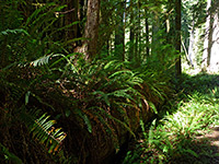 Length 1.3 miles (2.1 km) Elevation change 280 feet (85 meters) Trailhead Parking area along the Newton B Drury Scenic Parkway Rating (1-5) ★★★★★ From a trailhead on the east side of the scenic drive, this path follows the cool, well-watered ravine of Brown Creek where the giant redwoods grow particularly close together, before climbing gradually into a slightly drier environment of mixed fir and redwoods, up to a junction with the Rhododendron Trail. A good 3.4 mile loop hike can be made by walking south along this route for a mile then returning to the start point via the lesser-used South Fork Trail. |
|
Butler Creek Trail Length 1.8 miles (2.9 km) Elevation change 800 feet (244 meters) Trailhead Accessed via the Ossagon Trail, along the Coastal Drive Rating (1-5) ★★★★★ Linking the West Ridge Trail near its northern end with the Coastal Trail near Ossagon Creek, the Butler Creek route runs for while along a high ridge bearing many large redwoods then descends steeply through spruce forest and coastal woodland, into a cool ravine and out to the wide sands bordering the Pacific Ocean. |
Carruthers Cove Trail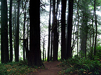 Length 0.8 miles (1.3 km) Elevation change 560 feet (171 meters) Trailhead Along the Coastal Drive Rating (1-5) ★★★★★ The northernmost trail in the state park starts a mile from the south end of the Coastal Drive; it descends steeply, through a small band of redwoods and into more diverse forest of red alder, sitka spruce and salmonberry. The path then enters an overgrown ravine at the lower end of Johnson Creek and emerges to a sandy section of Pacific Ocean beach (Carruthers Cove), next to a shallow lagoon and a large protruding cliff face. From here the Coastal Trail heads south, linking with the road to Fern Canyon. |
|
Cathedral Trees Trail Length 1.4 miles (2.3 km) Elevation change 50 feet (15 meters) Trailhead Big Tree parking area Rating (1-5) ★★★★★ The easy, mostly level Cathedral Trees Trail runs between the north edge of Elk Prairie and the Big Tree on the Circle Trail, en route passing countless huge redwoods, mixed with the usual dense array of ferns, moss, bushes and smaller trees. On the far side of the highway, the lower section of the Prairie Creek Trail allows hikers to make a 2.6 round trip, perhaps the best loop hike in the park for families with children. |
|
Circle Trail Length 0.3 miles (0.5 km) loop Elevation change level Trailhead Pull-out along the Newton B Drury Scenic Parkway Rating (1-5) ★★★★★ The most popular short path in the park loops around large redwoods alongside the scenic drive, starting a mile north of the visitor center. Amongst the redwoods on display is the Big Tree, one of the tallest in the area. |
|
Clintonia Trail Length 1 miles (1.6 km) Elevation change 200 feet (61 meters) Trailhead State park visitor center at Elk Meadow, from where the trail starts 3.5 miles west Rating (1-5) ★★★★★ The short Clintonia Trail connects the Miners Ridge and James Irvine Trails, crossing high ground covered mostly by spruce trees, though with some large redwoods towards the north end, around Home Creek. If starting at the visitor center, the trail can be used as the western section of an excellent 7.3 mile loop. |
|
Coastal Trail Length 3 miles (4.8 km) to the coast Elevation change 500 feet (152 meters) Trailhead End of Robinson Road Rating (1-5) ★★★★★ Just north of Orick, a short road heads a little way west along Skunk Cabbage Creek to a trailhead for the Coastal Trail, the section which leads northwards into Prairie Creek Redwoods State Park. The hike to the coast from here is 3 miles, passing a few redwoods near the beginning but for most of the way following a shallowish valley filled with regular trees. The last part climbs to a ridge overlooking the Pacific then descends to the beach, at a point just over a mile south of Davison Road. |
|
CREA Trail Length 1.4 miles (2.3 km) Elevation change 650 feet (198 meters) Trailhead Along US 101 Rating (1-5) ★★★★★ The lightly traveled CREA (California Real Estate Association) Trail links the north end of the Rhododendron Trail with US 101, crossing wooded hillsides high above Brown Creek and climbing to a rounded summit at 1,400 feet. |
|
Elk Prairie Trail Length 2.8 miles (4.5 km) (loop) Elevation change 80 feet (24 meters) Trailhead State park visitor center Rating (1-5) ★★★★★ This loop path circles all around the edge of the forest surrounding Elk Prairie and so offers good opportunities to see the resident elk, as well as many large redwoods. |
Fern Canyon Trail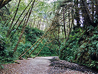 Length 0.7 miles (1.1 km) (loop) Elevation change 160 feet (49 meters) Trailhead North end of Davison Road Rating (1-5) ★★★★★ Perhaps the most unusual trail in Prairie Creek Redwoods State Park is the short loop around beautiful Fern Canyon, a sheer-sided, flat-floored ravine whose 30 foot walls are densely covered with dark green ferns. The path starts on Gold Bluffs Beach, accessed by the unpaved Davison Road (not for vehicles over 24 feet). |
|
Foothill Trail Length 2.2 miles (3.5 km) Elevation change 140 feet (43 meters) Trailhead Elk Prairie Rating (1-5) ★★★★★ This quite popular path through the redwood forest parallels the main road on the east side a little way up into the hills, at times running quite close to the highway and so subject to traffic noise, though in other places veering further eastwards away from the road in order to cross several steep ravines. |
|
Friendship Ridge Trail Length 3 miles (4.8 km) Elevation change 600 feet (183 meters) Trailhead Fern Canyon, from where the trail starts 0.7 miles east Rating (1-5) ★★★★★ Elk, solitude, old growth redwoods and far reaching ocean views are the main attractions of the Friendship Ridge Trail, a moderately strenuous route that starts in the south at a junction with the James Irvine Trail near Fern Canyon, and ends in the north at an intersection with the West Ridge Trail; all three paths can be used to form a 12.5 mile loop, perhaps the second best all-day hike in the state park (after the Miners Ridge/James Irvine loop). |
|
Hope Creek and Ten Taypo Trails Length 4 miles (6.4 km) (loop) Elevation change 450 feet (137 meters) Trailhead Pull-out along the Newton B Drury Scenic Parkway Rating (1-5) ★★★★★ On the east side of the scenic drive, these two trails form a 4 mile circuit through old growth redwood forest, traversing the fern-covered hillsides above two small creeks. The upper part of the route is through more traditional woodland, where the two paths are linked by a short section of old logging road, also accessible from US 101. |
|
|
James Irvine Trail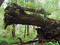 Length 5.1 miles (8.2 km) Elevation change 250 feet (76 meters) Trailhead Parking area by the state park visitor center Rating (1-5) ★★★★★ James Irvine is amongst the premier trails in the park, encountering some of the largest trees and the densest forest. The eastern trailhead is by the visitor center along the Drury Parkway, from where the path climbs gently along the wide valley of Godwood Creek, crosses a low saddle then descends the slightly narrower ravine formed by Home Creek, passing Fern Canyon and meeting the Coastal Trail along Gold Bluffs Beach. Walking south for 1.2 miles reaches the west end of the Miners Ridge Trail, which can be used to form an 11.5 mile loop - perhaps the best all-day hike in the area. |
|
Little Creek Trail Length 0.3 miles (0.5 km) Elevation change 100 feet (30 meters) Trailhead Pull-out along the Newton B Drury Scenic Parkway Rating (1-5) ★★★★★ One of the easiest trails in the state park follows a little stream a short distance east into the dense forest, passing many ancient fallen redwoods as well as numerous healthy living trees. |
Miners Ridge Trail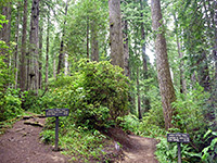 Length 3.6 miles (5.8 km) Elevation change 450 feet (137 meters) Trailhead Parking area by the state park visitor center Rating (1-5) ★★★★★ Forking off the James Irvine Trail near its eastern end, the Miners Ridge route climbs to a narrow ridge and drops down quite steeply towards Squashan Creek, entering a particularly cool, dark and overgrown section of the redwood forest. The path - established by gold miners in the 1880s - follows the creek downstream and exits the trees next to the campground at Gold Bluffs Beach. Together with the James Irvine Trail, the Coastal or Clintonia Trails enable a loop hike, of 11.7 or 7.3 miles respectively. |
|
Moorman Pond Trail Length 0.5 miles (0.8 km) Elevation change 200 feet (61 meters) Trailhead Pull-out along the Newton B Drury Scenic Parkway Rating (1-5) ★★★★★ A redwood grove dedicated to Charles H Moorman (a Sixth Circuit judge from Kentucky) and his wife Lily is the destination of the little-traveled Moorman Pond Trail, which follows a small creek, climbing gradually to the memorial trees. |
Ossagon Trail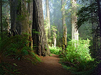 Length 2.7 miles (4.3 km) to the furthest rocks Elevation change 730 feet (223 meters) Trailhead Pull-out along the Newton B Drury Scenic Parkway Rating (1-5) ★★★★★ Starting near the north end of the scenic drive, the Ossagon Trail (a former logging track) is a varied route starting near the upper end of Prairie Creek; through old growth redwoods to a ridge then down into mixed coastal woodland, close to a pretty stream and out to grassland beside a wide, grey sand beach. Nearby are wetlands, freshwater pools and isolated rocks. |
Prairie Creek Trail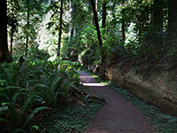 Length 4 miles (6.4 km) Elevation change 350 feet (107 meters) Trailhead Elk Prairie, in the south; there are several other access points Rating (1-5) ★★★★★ This trail runs most of the way along Prairie Creek, generally on the west side a short distance above the water, though crossing the stream several times and spending a little time on the east side. It can be accessed from several places along the scenic drive, and links with three paths that climb the steep hills to the west, up to the high ridge at the center of the park. Some sections are within hearing distance of the road but most are quiet and peaceful. All the route encounters very dense, old growth forest of redwoods and maples. |
|
Rhododendron Trail Length 6.3 miles (10.1 km) Elevation change 620 feet (189 meters) Trailhead Pull-out along the Newton B Drury Scenic Parkway Rating (1-5) ★★★★★ Few people hike the full length of the 6 mile Rhododendron Trail, though two connecting paths (the Brown Creek and South Fork Trails) allow various loop hikes including either the northern or southern sections (this latter seems to be the most scenic). The trail is named on account of the numerous rhododendrons that produce red and pink flowers in spring and summer, making the predominantly green landscape especially colorful and photogenic. The south trailhead is reached by a short walk along the Cathedral Trees Trail while the north end is half way along the scenic drive. |
South Fork Trail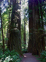 Length 1 miles (1.6 km) Elevation change 560 feet (171 meters) Trailhead Parking area along the Newton B Drury Scenic Parkway Rating (1-5) ★★★★★ Like the Brown Creek Trail just to the north, the South Fork Trail links the park road with the high elevation Rhododendron Trail, running mostly along a wooded ridge covered by ancient old growth redwoods, and gaining height quite steeply. The three trails can be used to form a 3.4 mile loop. |
|
West Ridge Trail Length 7 miles (11.3 km) Elevation change 640 feet (195 meters) Trailhead Elk Prairie Rating (1-5) ★★★★★ The longest trail in the state park begins at Elk Prairie in the south and climbs quite steeply to the top of the thickly forested ridge separating Prairie Creek valley from the smaller ravines bordering the Pacific Ocean. It follows the ridge northwards, staying fairly level for several miles before a slight descent to junctions with the Butler Creek and Friendship Ridge routes. Other paths link with the main road, so various shorter loop hikes are possible. |
All Contents © Copyright The American Southwest | Comments and Questions | Contribute | Affiliate Marketing Disclosure | Site Map