South Fork of Big Pine Creek Trail, Eastern Sierra
California > Eastern Sierra > South Fork of Big Pine Creek
South Fork of Big Pine Creek Trail
Lightly-traveled route up a broad valley, initially ascending gently, then much more steeply across scree slopes, over a ridge to shallow, marshy Willow Lake, then rising some more, through rocky woodland to granite-lined Brainerd Lake, giving spectacular views of the Palisade Crest
Length: 3.5 miles to Willow Lake, 5 miles to Brainerd Lake
Elevation change: 1,765 feet, 2,470 feet
Difficulty: Strenuous
Type: One-way
Usage: Low
Season: Early summer to early fall
Trailhead: Parking area near Glacier Lodge
Rating (1-5): ★★★★★
Elevation change: 1,765 feet, 2,470 feet
Difficulty: Strenuous
Type: One-way
Usage: Low
Season: Early summer to early fall
Trailhead: Parking area near Glacier Lodge
Rating (1-5): ★★★★★

The North Fork of Big Pine Creek is amongst the top hikes in the Eastern Sierra, passing a succession of beautiful lakes, different in character, accompanied by spectacular views, of peaks, and of Palisade Glacier. In contrast, the South Fork Trail is much less frequented, and only encounters two lakes, the shallow, boggy Willow Lake and very pretty Brainerd Lake, where the path ends.
Views along the way are still impressive, though rather more limited than the north fork, but the added solitude is an extra attraction. The hike to Brainerd Lake is 5 miles, gaining 1,760 feet; Willow Lake is about two thirds of the way in both distance and elevation, though not really worth visiting on its own, so the hike is only good if continuing to the upper lake.
27 views along the trail to the South Fork of Big Pine Creek
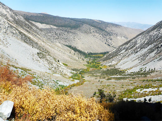
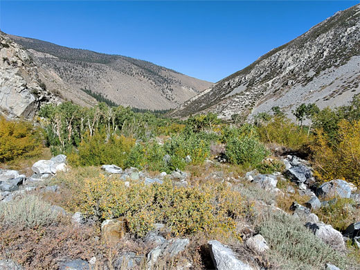
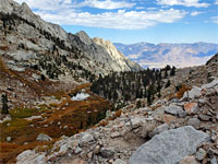
The paved road to the Big Pine Lakes trailhead, from Big Pine, ends in a small parking place in the woods, near the confluence of the North and South forks of Big Pine Creek - see the North Fork hike for more details. The one path from here starts along a short continuation of the road, past some houses, then on a path, following a stream - the North Fork, crossing it on a sturdy bridge just below a waterfall. The path divides soon after; the popular North Fork trail is right, the much less travelled South Fork route is left. This leaves the wooded corridor of the creek and enters the wide open floor of the South Fork valley, rising gently up the west side, crossing an old road then after a few minutes more, passing through a grove of aspen, quite close to the creek.
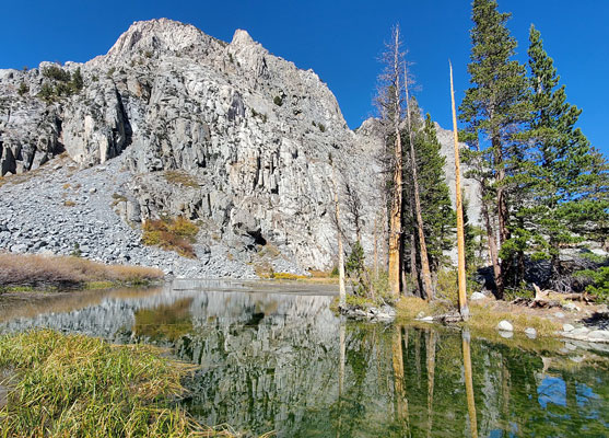
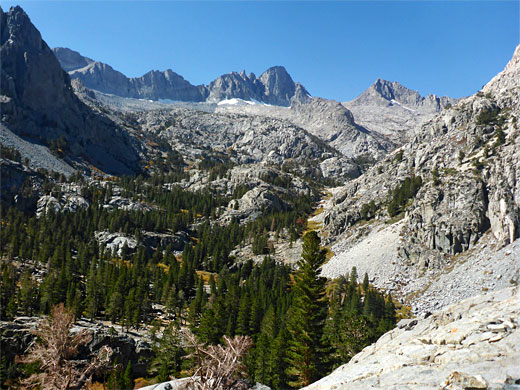
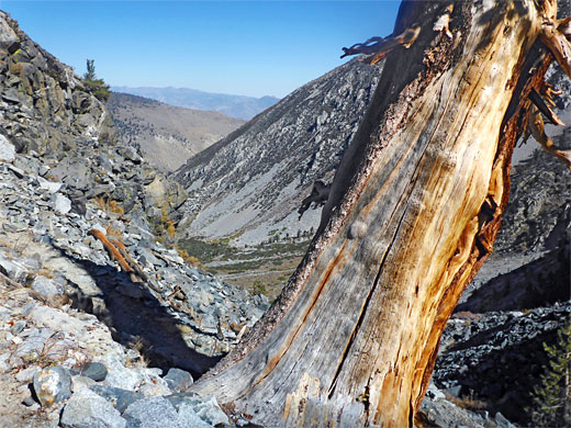
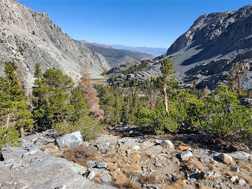
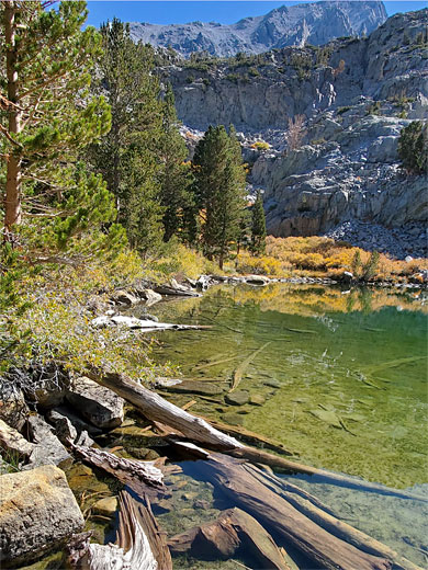
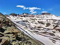
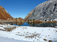
The surroundings become open once more for a while until the path approaches the stream again, now cutting through a mix of boulders and scattered trees. It crosses to the east side of the creek, coming close to the head of the lower section of the valley; much steeper slopes lie ahead. After passing into the John Muir Wilderness, marked by a sign, the route rises via switchbacks and over scree to the base of a cliff, past a few ancient pines, their trunks especially thick at the base. It cuts back west, climbing through more switchbacks, the surroundings now mostly bare rock rather than boulders; then into a little gulley, across some smooth granite slopes to a ridgetop, and down into a wooded basin, crossed by little streams and seeps. The high point, and some parts of the basin, afford grand views of the surrounding peaks and cliffs, including the distant Palisade Crest, before the trail enters thicker woods and reaches the junction with a short spur path to Willow Lake. This lake is shallow and muddy, lined by willow and long grass, the edges boggy in most places. A dramatic cliff of white granite rises to the west and this place also has good views, though the lake itself is not so scenic.
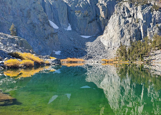
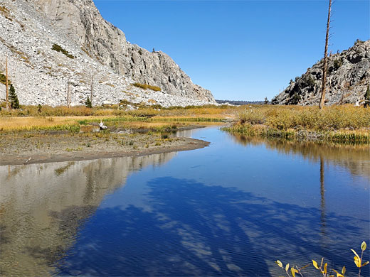
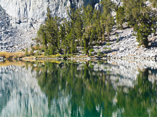
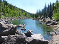
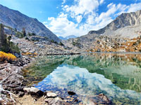
The continuation path crosses a stream, one of two feeding Willow Lake (also the exit stream from Brainerd Lake) then traverses through the woods, coming close to the other entry stream, the main South Fork, here flowing down a rocky, sheer-sided canyon, and originating over a thousand feet above at several other lakes including Elinor and Finger, places not reached by any trail. The path follows this canyon a short distance before moving away, back east, past a shallow muddy pond, up some more and out to the north shore of Brainerd Lake, surrounded by walls of granite on most sides, and providing perfect reflections on its clear waters. Bushes and cliffs mean it is not possible to walk very far along the shoreline. The lake is fed by one stream, on the east side, originating from two more (nameless) lakes, not too distant. On the return journey, a short-cut can be made by following the Lake Brainerd exit stream, most of which is through an open corridor of big granite boulders - the distance is 0.4 miles vs 0.9 miles on the trail.
Views along the way are still impressive, though rather more limited than the north fork, but the added solitude is an extra attraction. The hike to Brainerd Lake is 5 miles, gaining 1,760 feet; Willow Lake is about two thirds of the way in both distance and elevation, though not really worth visiting on its own, so the hike is only good if continuing to the upper lake.
Photographs
27 views along the trail to the South Fork of Big Pine Creek
South Fork of Big Pine Creek Video
Start of the Trail
The paved road to the Big Pine Lakes trailhead, from Big Pine, ends in a small parking place in the woods, near the confluence of the North and South forks of Big Pine Creek - see the North Fork hike for more details. The one path from here starts along a short continuation of the road, past some houses, then on a path, following a stream - the North Fork, crossing it on a sturdy bridge just below a waterfall. The path divides soon after; the popular North Fork trail is right, the much less travelled South Fork route is left. This leaves the wooded corridor of the creek and enters the wide open floor of the South Fork valley, rising gently up the west side, crossing an old road then after a few minutes more, passing through a grove of aspen, quite close to the creek.
Path to Willow Lake
The surroundings become open once more for a while until the path approaches the stream again, now cutting through a mix of boulders and scattered trees. It crosses to the east side of the creek, coming close to the head of the lower section of the valley; much steeper slopes lie ahead. After passing into the John Muir Wilderness, marked by a sign, the route rises via switchbacks and over scree to the base of a cliff, past a few ancient pines, their trunks especially thick at the base. It cuts back west, climbing through more switchbacks, the surroundings now mostly bare rock rather than boulders; then into a little gulley, across some smooth granite slopes to a ridgetop, and down into a wooded basin, crossed by little streams and seeps. The high point, and some parts of the basin, afford grand views of the surrounding peaks and cliffs, including the distant Palisade Crest, before the trail enters thicker woods and reaches the junction with a short spur path to Willow Lake. This lake is shallow and muddy, lined by willow and long grass, the edges boggy in most places. A dramatic cliff of white granite rises to the west and this place also has good views, though the lake itself is not so scenic.
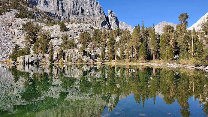
Brainerd Lake
The continuation path crosses a stream, one of two feeding Willow Lake (also the exit stream from Brainerd Lake) then traverses through the woods, coming close to the other entry stream, the main South Fork, here flowing down a rocky, sheer-sided canyon, and originating over a thousand feet above at several other lakes including Elinor and Finger, places not reached by any trail. The path follows this canyon a short distance before moving away, back east, past a shallow muddy pond, up some more and out to the north shore of Brainerd Lake, surrounded by walls of granite on most sides, and providing perfect reflections on its clear waters. Bushes and cliffs mean it is not possible to walk very far along the shoreline. The lake is fed by one stream, on the east side, originating from two more (nameless) lakes, not too distant. On the return journey, a short-cut can be made by following the Lake Brainerd exit stream, most of which is through an open corridor of big granite boulders - the distance is 0.4 miles vs 0.9 miles on the trail.
South Fork of Big Pine Creek Trail - Similar Hikes
All Contents © Copyright The American Southwest | Comments and Questions | Contribute | Affiliate Marketing Disclosure | Site Map