
Columbine Lake
Path of three parts, forest, meadows and tundra, climbing steeply at first then nearly level towards the end, leading to a beautiful high elevation lake, enclosed on three sides by rocky ridges
Length: 3.3 miles, plus up to 0.7 miles to reach the trailhead
Elevation change: 2,325 feet
Difficulty: Strenuous
Type: One way
Usage: Low
Season: Midsummer and early fall
Trailhead: Along a track (FR 820); off US 550, 5 miles south of Red Mountain Pass
Rating (1-5): ★★★★★
Elevation change: 2,325 feet
Difficulty: Strenuous
Type: One way
Usage: Low
Season: Midsummer and early fall
Trailhead: Along a track (FR 820); off US 550, 5 miles south of Red Mountain Pass
Rating (1-5): ★★★★★

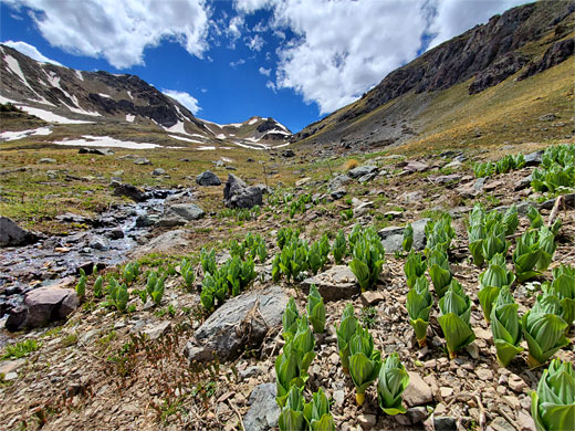
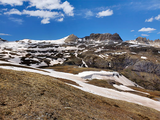
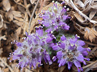
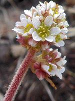
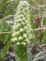
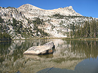
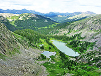
Columbine Lake sits at the upper end of a high elevation basin in the San Juan Mountains, ringed by ridgeline peaks to the north, west and south, the highest 13,661 foot Lookout Peak. As its name suggests, the rocky land around the lake is filled with Colorado columbines in the summer, along with many other wildflowers, blooming most strongly from mid July to the end of August. The surroundings are tundra - stony terrain with short grass and shallow soils, yet this supports a good diversity of plants, including several uncommon species.
The little-used, dead-end path to the lake is 3.3 miles in length, climbing 2,325 feet, and has three distinct sections. The first third is steep, switchbacking through pine woods, the middle section rises above the treeline ascending more gradually through an Alpine basin then more sharply up to a saddle, while the last part is much less steep, traversing a tundra slope high above the adjacent valley of Mill Creek, to the upper basin containing the lake. Views are consistently spectacular once out of the trees.
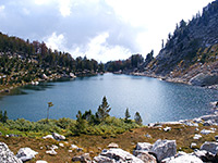
The lake itself has a beautiful turquoise-blue color, similar to the better known Ice Lake 4 miles south, and is a good fishing location, for brook trout. The place is usually accessible to regular hikers towards the end of June, since large snow fields persist until then.
One reason for the relative lack of visitors is the rather hidden trailhead - although close to US 550 along Mineral Creek valley, 5 miles south of Red Mountain Pass, it is located along a dirt track on the opposite side of the creek, which can be difficult to cross early in the season because of snowmelt.
San Juan Mountains area map, Columbine Lake Basin topographic map.
24 views along the Columbine Lake Trail.
The trailhead is halfway along FR 820, a short (1.8 mile) track that leaves US 550, heads north very close to the highway for half a mile then fords the creek, climbs a bit and turns back south, ending at a junction with Ophir Pass Road, a much wider track that crosses the creek on a bridge. The trail is best approached from the south end of the track, though parking is limited and the track is not suitable for larger vehicles, so another option is to park either on US 550 or Ophir Pass Road and walk to the trailhead. For the former option the distance can be shortened slightly by using a cut-off trail. The actual start point is not so obvious; a narrow path into the woods marked by small sign with a trail number, 509, about 800 feet south of the spoil heaps from Imogene Mine, a minor, disused operation. Depending on the route, walking to the trailhead from either of the two parking places involves an extra 0.3 to 0.7 miles, and up to another 200 feet of climbing.
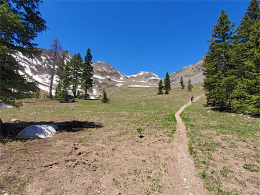
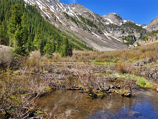
The path starts off in pine forest and climbs steeply, with switchbacks, initially short, becoming longer as the gradient lessens somewhat. Views are restricted by the tall trees growing close together. The forest is rather dry, with no streams or seeps, so wildflowers are also limited. Eventually the trees become more widely spaced, and shorter, so the views improve, the patches of sky above become larger, and the path levels out, crests the brow of a little hill and approaches a meadow beside the (unnamed) stream that drains the basin above. Residual snow can persist quite late in the season hereabouts.
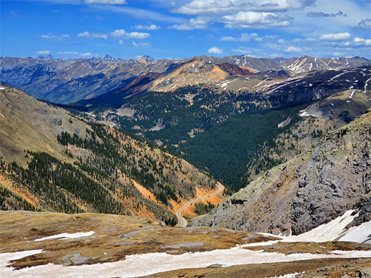
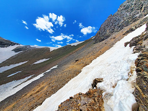
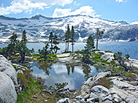
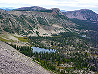
The forest ends abruptly not far beyond the meadow, and the path leaves the shady trees and enters a broad Alpine basin, framed by smooth slopes at either side, increasingly rocky higher up. Behind, to the east, is a grand vista across Mineral Creek valley towards countless other peaks and ridges in the central section of the San Juan Mountains. The trail is now straight, no more switchbacks, heading up the basin, crossing the creek once and alternating between almost level sections and short, steeper parts, on to the head of the valley, where it curves northwards, traverses a talus field and reaches a rocky saddle, below two minor peaks - a divide between the basin and the valley of Mill Creek to the north.
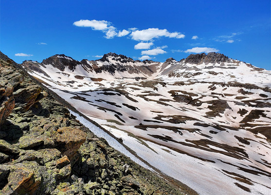
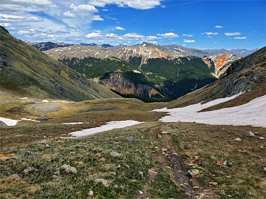
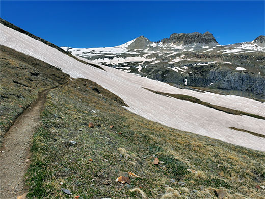
The last third of the path is the easiest as from the saddle it becomes almost level - traversing a broad slope, gradually bending westwards, running below a narrow, jagged ridge to the south and within sight of a similar crest to the north, on the far side of Mill Creek, this centered on a narrow summit known as Telluride 11 Peak. The path crosses a little drainage, some boggy places and extensive tundra meadows, the surroundings becoming rockier towards the end; a patch of scree followed by exposed granite, before arriving at the east shore of the lake, which is a quarter of a mile across and quite easy to follow along its northern slopes, but not to the south as the sides are too steep. The water has a beautiful turquoise color due to suspended sediment from melting snow, and it is relatively easy in some places to climb the enclosing ridges, for even better views.
The little-used, dead-end path to the lake is 3.3 miles in length, climbing 2,325 feet, and has three distinct sections. The first third is steep, switchbacking through pine woods, the middle section rises above the treeline ascending more gradually through an Alpine basin then more sharply up to a saddle, while the last part is much less steep, traversing a tundra slope high above the adjacent valley of Mill Creek, to the upper basin containing the lake. Views are consistently spectacular once out of the trees.
The lake itself has a beautiful turquoise-blue color, similar to the better known Ice Lake 4 miles south, and is a good fishing location, for brook trout. The place is usually accessible to regular hikers towards the end of June, since large snow fields persist until then.
One reason for the relative lack of visitors is the rather hidden trailhead - although close to US 550 along Mineral Creek valley, 5 miles south of Red Mountain Pass, it is located along a dirt track on the opposite side of the creek, which can be difficult to cross early in the season because of snowmelt.
Location
San Juan Mountains area map, Columbine Lake Basin topographic map.
Photographs
24 views along the Columbine Lake Trail.
Video
Columbine Lake Trailhead
The trailhead is halfway along FR 820, a short (1.8 mile) track that leaves US 550, heads north very close to the highway for half a mile then fords the creek, climbs a bit and turns back south, ending at a junction with Ophir Pass Road, a much wider track that crosses the creek on a bridge. The trail is best approached from the south end of the track, though parking is limited and the track is not suitable for larger vehicles, so another option is to park either on US 550 or Ophir Pass Road and walk to the trailhead. For the former option the distance can be shortened slightly by using a cut-off trail. The actual start point is not so obvious; a narrow path into the woods marked by small sign with a trail number, 509, about 800 feet south of the spoil heaps from Imogene Mine, a minor, disused operation. Depending on the route, walking to the trailhead from either of the two parking places involves an extra 0.3 to 0.7 miles, and up to another 200 feet of climbing.
Woodland
The path starts off in pine forest and climbs steeply, with switchbacks, initially short, becoming longer as the gradient lessens somewhat. Views are restricted by the tall trees growing close together. The forest is rather dry, with no streams or seeps, so wildflowers are also limited. Eventually the trees become more widely spaced, and shorter, so the views improve, the patches of sky above become larger, and the path levels out, crests the brow of a little hill and approaches a meadow beside the (unnamed) stream that drains the basin above. Residual snow can persist quite late in the season hereabouts.
The Lower Basin
The forest ends abruptly not far beyond the meadow, and the path leaves the shady trees and enters a broad Alpine basin, framed by smooth slopes at either side, increasingly rocky higher up. Behind, to the east, is a grand vista across Mineral Creek valley towards countless other peaks and ridges in the central section of the San Juan Mountains. The trail is now straight, no more switchbacks, heading up the basin, crossing the creek once and alternating between almost level sections and short, steeper parts, on to the head of the valley, where it curves northwards, traverses a talus field and reaches a rocky saddle, below two minor peaks - a divide between the basin and the valley of Mill Creek to the north.
Path to the Lake
The last third of the path is the easiest as from the saddle it becomes almost level - traversing a broad slope, gradually bending westwards, running below a narrow, jagged ridge to the south and within sight of a similar crest to the north, on the far side of Mill Creek, this centered on a narrow summit known as Telluride 11 Peak. The path crosses a little drainage, some boggy places and extensive tundra meadows, the surroundings becoming rockier towards the end; a patch of scree followed by exposed granite, before arriving at the east shore of the lake, which is a quarter of a mile across and quite easy to follow along its northern slopes, but not to the south as the sides are too steep. The water has a beautiful turquoise color due to suspended sediment from melting snow, and it is relatively easy in some places to climb the enclosing ridges, for even better views.
Columbine Lake Wildflowers
More flowers along the trail
 Alpine kitten tails |
 Diamond-leaf pseudosaxifrage |
 Sky pilot |
 Ritters' coraldrops |
More flowers along the trail
Columbine Lake Trail - Similar Hikes
All Contents © Copyright The American Southwest | Comments and Questions | Contribute | Affiliate Marketing Disclosure | Site Map