Conness Lakes and Twenty Lakes Basin, Eastern Sierra
California > Eastern Sierra > Conness Lakes and Twenty Lakes Basin


Conness Lakes and Twenty Lakes Basin
Exploration of a spectacular, high elevation basin just east of the Sierra crest, containing many lakes, linked by small streams, bordered by meadows and rocky outcrops. Along the boundary between the granite peaks of the main part of the mountains, and the darker, metamorphic rocks to the east
Length: 12.5 miles, round trip
Elevation change: 700 feet
Difficulty: Moderate; long, but fairly level overall
Type: Loop
Usage: Low
Season: Early summer to early fall
Trailhead: End of the unpaved road to Saddlebag Lake
Rating (1-5): ★★★★★
Elevation change: 700 feet
Difficulty: Moderate; long, but fairly level overall
Type: Loop
Usage: Low
Season: Early summer to early fall
Trailhead: End of the unpaved road to Saddlebag Lake
Rating (1-5): ★★★★★

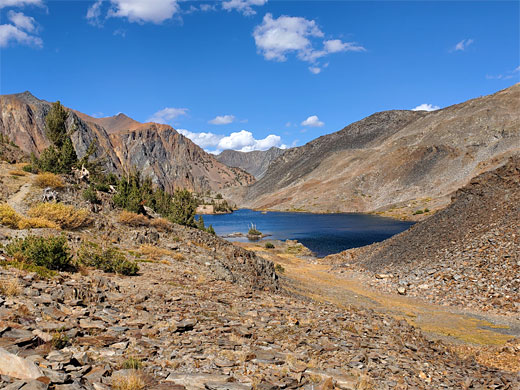
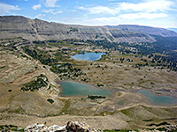
Twenty Lakes Basin, not marked on most maps, is the semi-official name of a spectacular high elevation region just east of the Sierra crest, a few miles north of the Tioga Pass, within Inyo National Forest, and mostly part of the Hoover Wilderness. There are ten named lakes here plus many smaller ponds and pools, linked by streams and surrounded by meadows and rocky outcrops, while just to the south are even more lakes - the large Saddleback Lake (formed by a dam; all others are natural) and the smaller Conness Lakes, three of them. Numerous wildflowers bloom here in the summer, many dozens of species, and the whole area is a perfect example of a pristine high mountain environment.
All the basin is broadly similar in elevation, so the 12.5 mile loop hike visiting all the main lakes involves just a few short climbs and descents, and the highest point, Upper Conness Lake, is only 700 feet above the trailhead at the south end of Saddleback Lake, this reached by a 2.9 mile drive along an unpaved track, starting along Tioga Road, Hwy 120.
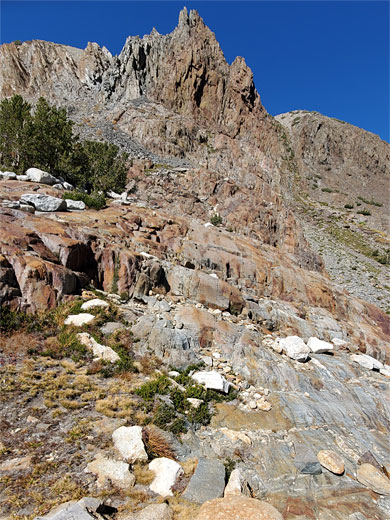
Rocks towards the west of this area, around the Conness Lakes, are granitic (Cathedral Peak granodiorite), like much of the Sierra Nevada, while to the east they transition to darker, metamorphic strata, including rhyolitic tuff, hornfels and tuffaceous sandstone.
Several shorter hikes are possible - shortest is the loop all around Saddlebag Lake, 4 miles, though this is not so interesting as the terrain is little-changing all the way; open, treeless, rocky slopes to the southwest, just a little more wooded to the northeast. To see the Conness Lakes is 4 miles one way, or 9.4 miles if including the Saddleback loop, while the Twenty Lakes Basin-Saddlebag loop is 9.7 miles.
53 views along the trail to Conness Lakes and Twenty Lakes Basin
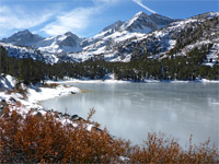
Saddlebag Lake Road forks north off Hwy 120 near Ellery Lake, 2 miles north of the Tioga entrance to Yosemite National Park. At the intersection is the USFS Junction Campground beside Mine Creek, at the start of a path to Bennettville mine and ghost town. The road to the lake is rather bumpy, briefly paved at two steep places but otherwise gravel, and it ends after 2.9 miles beside the dam over Lee Vining Creek which created Saddlebag Lake in 1919. Facilities here include group and regular campgrounds, a cafe/store, a boat launch ramp and a day-use parking area. Saddlebag is one of the highest lakes in the Sierra Nevada that is reachable by road, elevation 10,067 feet.
The shortest route to the Conness Lakes and/or Twenty Lakes Basin is along the west side of Saddlebag Lake, and this path starts by crossing the top of the concrete dam over Lee Vining Creek and traversing the rather barren slopes beyond, staying around 50 feet above the water, across scree and rock. Towards the north end of the lake it veers west and arrives at a junction, in a grassy, marshy basin; the Twenty Lakes route is right while left is to the Conness Lakes. This latter path soon reaches the next lake, Greenstone, named for the color of the bedrock hereabouts. This is prettier than Saddleback, quite shallow, marshy around the edge, cliff-lined to one side. A sign marks the boundary of Harvey Monroe Hall Research Natural Area, a scientific and educational preserve.
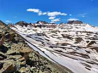
The path continues along the Greenstone Lake entry stream, the very upper end of Lee Vining Creek; it climbs a line of low cliffs, through a few meadows and patches of trees to the rim of the Conness basin, and the first of its lakes, continuing along the south shore and up a slope to the southernmost lake, a closely spaced pair, set beneath the permanent snowfield of Conness Glacier, one of 15 glaciers in the Sierra Nevada. A short off-trail walk north, over a white granite divide, leads to Upper Conness Lake, crossed at one corner by a natural rock causeway. A path drops down through scree and slickrock, back to Lower Conness Lake, from where the original trail is followed down to Greenstone Lake, and a junction, at which the left fork heads north into Twenty Lakes Basin.
This next path, wider than before, runs along the north shore of Greenstone Lake a short distance before turning away, gently switchbacking up a slope and becoming straight, alongside a reddish rock ridge, later turning left at a junction (right is to Z Lake and the Twin Lakes), down to the north end of the thin, shallow Wesco Lake. It resumes a northwards course, alongside a tiny stream in a shallow gully, to the much bigger Steelhead Lake, named of course for the steelhead trout which dwell here. The trail runs on a broad bench on the east side of the lake, past a junction with a minor path that climbs to the site of Hess Mine, where small amounts of tungsten ore were extracted between the 1940s and 1960s. The main path follows the lake's exit stream (Mill Creek), alongside ponds and a small, pretty, unnamed lake then down some more to the even more beautiful Shamrock Lake, lined by rock promontories and dotted with a few small islands. The surrounding land is crossed by many little streams and seeps, all very scenic, with long-distance views northeast.
From Shamrock Lake, the trail crosses a stream and descends a little more to Lake Helen, which looks deep, and is bordered by scree slopes on the far side. The trail divides at the north end of this lake; the left path starts a long descent of Mill Creek, towards Lundy Lake, while the right branch forms the return part of the Twenty Lakes Loop. This follows the shore of Lake Helen a little way, over the rocky slopes then climbs a steep, scree-filled ravine, and emerges to open, dry, somewhat less scenic surroundings, past Odell Lake, over a minor divide (Lundy Pass) and on to the final lake, Hummingbird, followed by a gentle descent to the north end of Saddlebag Lake, from where the shortest route back to the trailhead is along the west side, as before. The eastern route passes through sparse woodland at first, then the terrain is mostly open, the path cutting across a promontory at one point but otherwise staying close to the shore, and eventually reaching a fishing area at the far end of the lake access road.
All the basin is broadly similar in elevation, so the 12.5 mile loop hike visiting all the main lakes involves just a few short climbs and descents, and the highest point, Upper Conness Lake, is only 700 feet above the trailhead at the south end of Saddleback Lake, this reached by a 2.9 mile drive along an unpaved track, starting along Tioga Road, Hwy 120.
Rocks towards the west of this area, around the Conness Lakes, are granitic (Cathedral Peak granodiorite), like much of the Sierra Nevada, while to the east they transition to darker, metamorphic strata, including rhyolitic tuff, hornfels and tuffaceous sandstone.
Several shorter hikes are possible - shortest is the loop all around Saddlebag Lake, 4 miles, though this is not so interesting as the terrain is little-changing all the way; open, treeless, rocky slopes to the southwest, just a little more wooded to the northeast. To see the Conness Lakes is 4 miles one way, or 9.4 miles if including the Saddleback loop, while the Twenty Lakes Basin-Saddlebag loop is 9.7 miles.
Photographs
53 views along the trail to Conness Lakes and Twenty Lakes Basin
Conness Lakes and Twenty Lakes Basin Video
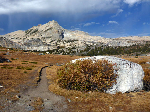
Twenty Lakes Basin Trailhead
Saddlebag Lake Road forks north off Hwy 120 near Ellery Lake, 2 miles north of the Tioga entrance to Yosemite National Park. At the intersection is the USFS Junction Campground beside Mine Creek, at the start of a path to Bennettville mine and ghost town. The road to the lake is rather bumpy, briefly paved at two steep places but otherwise gravel, and it ends after 2.9 miles beside the dam over Lee Vining Creek which created Saddlebag Lake in 1919. Facilities here include group and regular campgrounds, a cafe/store, a boat launch ramp and a day-use parking area. Saddlebag is one of the highest lakes in the Sierra Nevada that is reachable by road, elevation 10,067 feet.
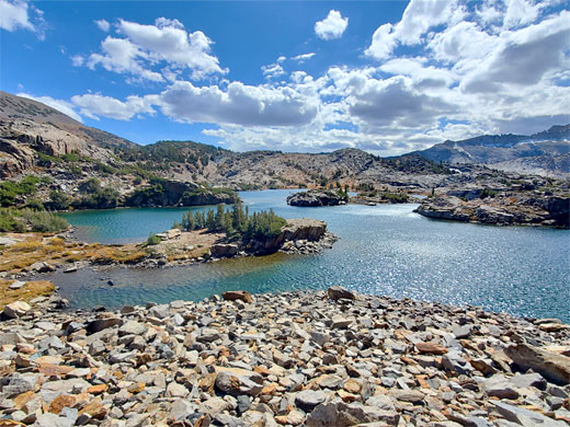
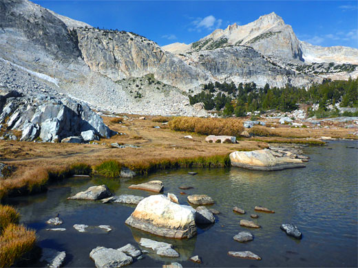
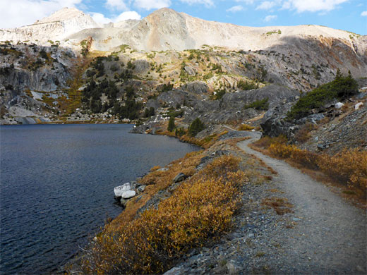
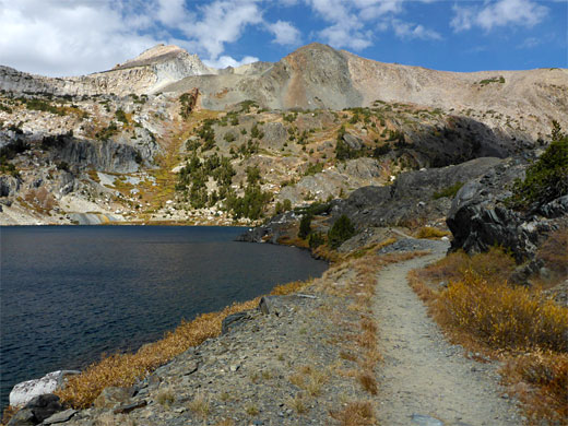
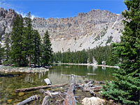
Saddlebag Lake and Greenstone Lake
The shortest route to the Conness Lakes and/or Twenty Lakes Basin is along the west side of Saddlebag Lake, and this path starts by crossing the top of the concrete dam over Lee Vining Creek and traversing the rather barren slopes beyond, staying around 50 feet above the water, across scree and rock. Towards the north end of the lake it veers west and arrives at a junction, in a grassy, marshy basin; the Twenty Lakes route is right while left is to the Conness Lakes. This latter path soon reaches the next lake, Greenstone, named for the color of the bedrock hereabouts. This is prettier than Saddleback, quite shallow, marshy around the edge, cliff-lined to one side. A sign marks the boundary of Harvey Monroe Hall Research Natural Area, a scientific and educational preserve.
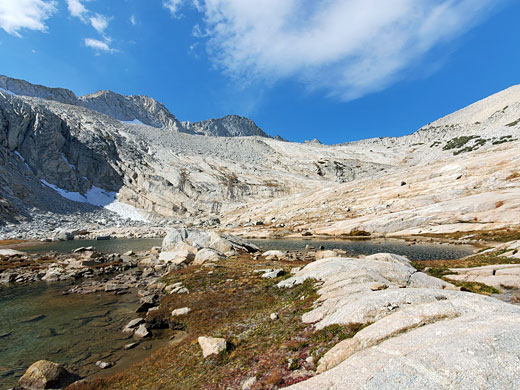
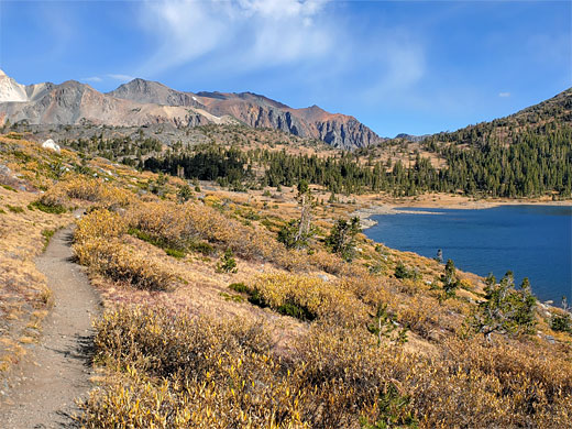
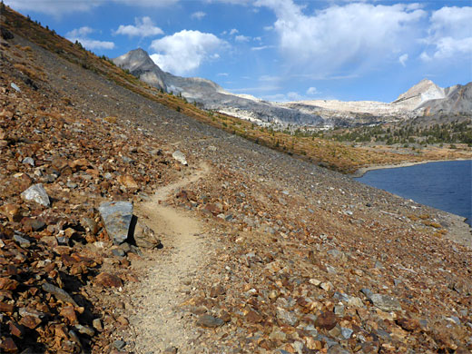
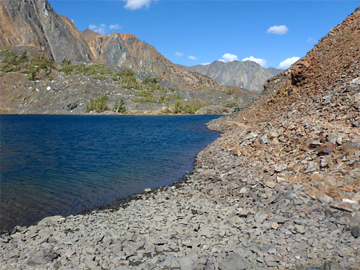
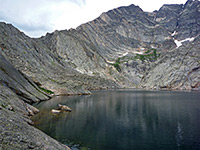
Conness Lakes
The path continues along the Greenstone Lake entry stream, the very upper end of Lee Vining Creek; it climbs a line of low cliffs, through a few meadows and patches of trees to the rim of the Conness basin, and the first of its lakes, continuing along the south shore and up a slope to the southernmost lake, a closely spaced pair, set beneath the permanent snowfield of Conness Glacier, one of 15 glaciers in the Sierra Nevada. A short off-trail walk north, over a white granite divide, leads to Upper Conness Lake, crossed at one corner by a natural rock causeway. A path drops down through scree and slickrock, back to Lower Conness Lake, from where the original trail is followed down to Greenstone Lake, and a junction, at which the left fork heads north into Twenty Lakes Basin.
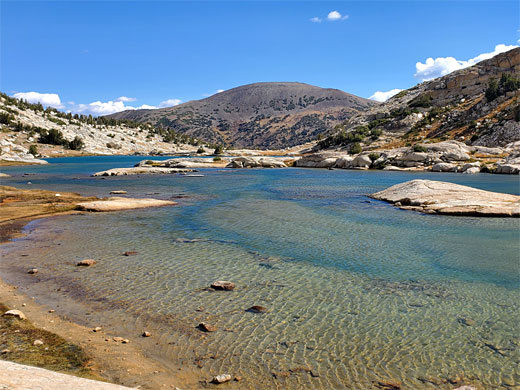
Wesco, Steelhead and Shamrock Lakes
This next path, wider than before, runs along the north shore of Greenstone Lake a short distance before turning away, gently switchbacking up a slope and becoming straight, alongside a reddish rock ridge, later turning left at a junction (right is to Z Lake and the Twin Lakes), down to the north end of the thin, shallow Wesco Lake. It resumes a northwards course, alongside a tiny stream in a shallow gully, to the much bigger Steelhead Lake, named of course for the steelhead trout which dwell here. The trail runs on a broad bench on the east side of the lake, past a junction with a minor path that climbs to the site of Hess Mine, where small amounts of tungsten ore were extracted between the 1940s and 1960s. The main path follows the lake's exit stream (Mill Creek), alongside ponds and a small, pretty, unnamed lake then down some more to the even more beautiful Shamrock Lake, lined by rock promontories and dotted with a few small islands. The surrounding land is crossed by many little streams and seeps, all very scenic, with long-distance views northeast.
Helen, Odell and Hummingbird Lake
From Shamrock Lake, the trail crosses a stream and descends a little more to Lake Helen, which looks deep, and is bordered by scree slopes on the far side. The trail divides at the north end of this lake; the left path starts a long descent of Mill Creek, towards Lundy Lake, while the right branch forms the return part of the Twenty Lakes Loop. This follows the shore of Lake Helen a little way, over the rocky slopes then climbs a steep, scree-filled ravine, and emerges to open, dry, somewhat less scenic surroundings, past Odell Lake, over a minor divide (Lundy Pass) and on to the final lake, Hummingbird, followed by a gentle descent to the north end of Saddlebag Lake, from where the shortest route back to the trailhead is along the west side, as before. The eastern route passes through sparse woodland at first, then the terrain is mostly open, the path cutting across a promontory at one point but otherwise staying close to the shore, and eventually reaching a fishing area at the far end of the lake access road.
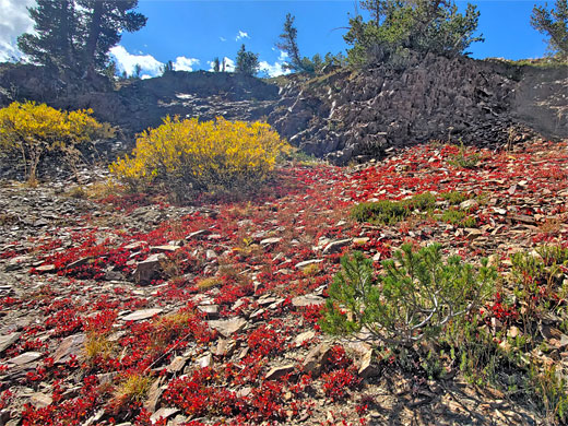
Twenty Lakes Basin Wildflowers
More flowers along the trail
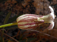 Sargent's catchfly |
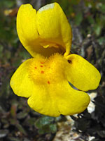 Subalpine monkey-flower |
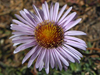 Sierra fleabane |
More flowers along the trail
Conness Lakes and Twenty Lakes Basin - Similar Hikes
All Contents © Copyright The American Southwest | Comments and Questions | Contribute | Affiliate Marketing Disclosure | Site Map