Skidoo
Old townsite, now completely empty, but near several fascinating mining relics, set in remote, deserted terrain on the west side of the Panamint Range, and reached by an 8 mile unpaved road. All major sites can be seen via several short hikes, of less than half a mile
Season: All year, though very hot in summer; temperatures only partly moderated by the 5,700 foot elevation. Access road may be covered by snow in winter
Location: End of a track branching off Wildrose Road
Rating (1-5): ★★★★★
Location: End of a track branching off Wildrose Road
Rating (1-5): ★★★★★

About half a dozen significant towns once existed in the Death Valley area, all thriving for only a short time until the nearby mines were exhausted. Some like Darwin and Rhyolite are still partly inhabited, but nothing remains of Skidoo, which was built in a remote valley at 5,700 feet elevation, on the west side of the Panamint Range near Emigrant Canyon and the Harrisburg Flats. The old street grid is faintly discernible in a few places, now covered by the ubiquitous sagebrush, and small fragments of glass and masonry may be found, though the last buildings in town disappeared decades ago.
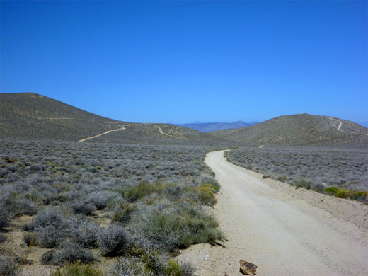
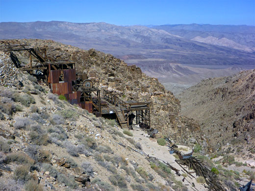
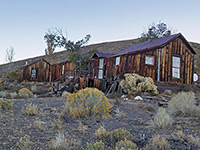
However, the surrounding hills contain over a thousand mine entrances and workings, plus dozens of associated structures - wooden cabins, headframes, iron machinery, old cars and, most visibly, the Skidoo Stamp Mill, situated high in a side canyon near the edge of a steep hillside, sloping down 3,000 feet towards Telephone Canyon. The townsite and mining district are reached by an 8 mile unpaved road, generally fine for regular vehicles, which forks off Wildrose Road 9.4 miles from CA 190; the area may be explored by short hikes, to the mine sites in the surrounding hills, which are all uniformly devoid of trees or bushes.
Map of Death Valley National Park.
24 views of Skidoo and surroundings.
Skidoo owed its brief existence to the 1906 discovery of gold by two miners en route to the nearby settlement of Harrisburg. The population grew quickly, peaking at around 700, but all had left within ten years once the ore was finished, and 75,000 ounces of gold had been extracted. The stamp mill, still largely intact, was notable for being the only one in the Death Valley region to be powered by water, using a supply piped with great difficulty from a spring on Telescope Peak, 15 miles south. Skidoo had such advanced facilities as a telephone exchange, post office, newspaper press, school and bank, but last buildings were gone by the 1980s.
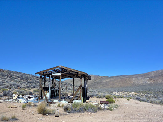
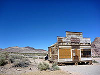
The first 4 miles of Skidoo Road are quite good, before the surface deteriorates as the road climbs a ravine and traverses a hillside to the townsite. The road starts across a flat desert plain then winds through a small range of hills, reaching the first two sites after 2.8 miles; a single room cabin on the north side, and a mine headframe on the south, at the end of a short track. A sturdy ladder leads down the shaft beneath, but like nearly all the mine entrances in the vicinity, the opening is securely closed, here by thick wire netting. As the road turns north, another evocative ruin comes into view, to the west; now just a wooden framework with remains of a sink and bench, this used to be a dwelling, built near several mines in the neighboring hills.
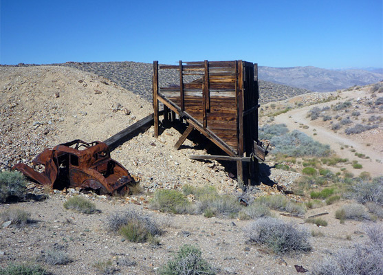
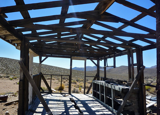
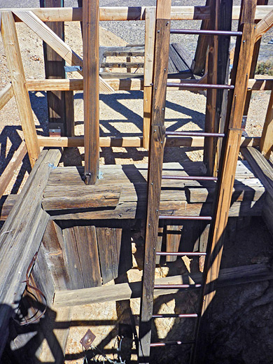
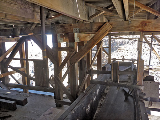
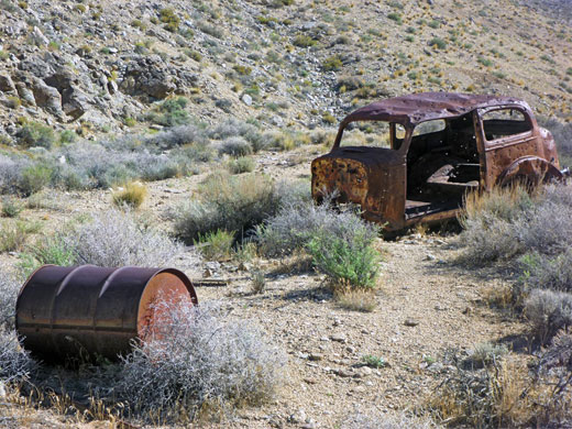
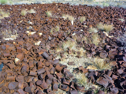
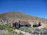
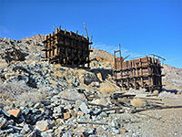
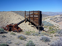
The road ascends the ravine, turns back west and enters a low valley, reaching Skidoo townsite after 7 miles, now marked only by an NPS noticeboard, as there are no signs of any buildings. The road continues a little way, splitting into rougher tracks along the valley floor and up into the hills on both sides. The ground falls away steeply not far ahead, down to Emigrant and Telephone canyons, and the hillsides give good, long distance views to the north and west. The main branch of the road passes a wooden hopper and a rusty car, then ends at Skidoo Stamp Mill, quite a well preserved structure guarded by several keep-out notices. Higher up are other wooden relics, shafts, adits, stone foundations and much debris including glass fragments, metal objects and great piles of rusty cans, many thousands in some places. All around stretch barren, featureless hills, bearing only straggly bushes; a most unforgiving landscape, very hot for most of the year.
However, the surrounding hills contain over a thousand mine entrances and workings, plus dozens of associated structures - wooden cabins, headframes, iron machinery, old cars and, most visibly, the Skidoo Stamp Mill, situated high in a side canyon near the edge of a steep hillside, sloping down 3,000 feet towards Telephone Canyon. The townsite and mining district are reached by an 8 mile unpaved road, generally fine for regular vehicles, which forks off Wildrose Road 9.4 miles from CA 190; the area may be explored by short hikes, to the mine sites in the surrounding hills, which are all uniformly devoid of trees or bushes.
Location
Map of Death Valley National Park.
Photographs
24 views of Skidoo and surroundings.
History of Skidoo
Skidoo owed its brief existence to the 1906 discovery of gold by two miners en route to the nearby settlement of Harrisburg. The population grew quickly, peaking at around 700, but all had left within ten years once the ore was finished, and 75,000 ounces of gold had been extracted. The stamp mill, still largely intact, was notable for being the only one in the Death Valley region to be powered by water, using a supply piped with great difficulty from a spring on Telescope Peak, 15 miles south. Skidoo had such advanced facilities as a telephone exchange, post office, newspaper press, school and bank, but last buildings were gone by the 1980s.
Road to Skidoo
The first 4 miles of Skidoo Road are quite good, before the surface deteriorates as the road climbs a ravine and traverses a hillside to the townsite. The road starts across a flat desert plain then winds through a small range of hills, reaching the first two sites after 2.8 miles; a single room cabin on the north side, and a mine headframe on the south, at the end of a short track. A sturdy ladder leads down the shaft beneath, but like nearly all the mine entrances in the vicinity, the opening is securely closed, here by thick wire netting. As the road turns north, another evocative ruin comes into view, to the west; now just a wooden framework with remains of a sink and bench, this used to be a dwelling, built near several mines in the neighboring hills.
Skidoo Townsite and Mining District
The road ascends the ravine, turns back west and enters a low valley, reaching Skidoo townsite after 7 miles, now marked only by an NPS noticeboard, as there are no signs of any buildings. The road continues a little way, splitting into rougher tracks along the valley floor and up into the hills on both sides. The ground falls away steeply not far ahead, down to Emigrant and Telephone canyons, and the hillsides give good, long distance views to the north and west. The main branch of the road passes a wooden hopper and a rusty car, then ends at Skidoo Stamp Mill, quite a well preserved structure guarded by several keep-out notices. Higher up are other wooden relics, shafts, adits, stone foundations and much debris including glass fragments, metal objects and great piles of rusty cans, many thousands in some places. All around stretch barren, featureless hills, bearing only straggly bushes; a most unforgiving landscape, very hot for most of the year.
Skidoo - Similar Hikes
All Contents © Copyright The American Southwest | Comments and Questions | Contribute | Affiliate Marketing Disclosure | Site Map