Rhyolite
Small but interesting ghost town near Beatty; the settlement flourished for a few years after discovery of gold in the surrounding hills. Today only around a dozen buildings remain, in various stages of disrepair, but the site is evocative and photogenic
Season: All year; summers are very hot but there is no hiking necessary to see the ruins
Location: End of a short paved road forking off NV 374, west of Beatty
Rating (1-5): ★★★★★
Location: End of a short paved road forking off NV 374, west of Beatty
Rating (1-5): ★★★★★

Like countless other Southwestern mining towns, Rhyolite flourished for just a few years, until the gold ores in the surrounding hills were exhausted, but at its peak in 1908 the place was a substantial settlement, home to over 5,000 residents and boasting such advanced facilities as a school, opera house, bank, railway station, swimming pool and stock exchange.
The town declined rapidly after the brief boom and was largely abandoned by the early 1920s; most of the buildings are now completely gone and just a few of the larger establishments remain, in various stages of dereliction, though Rhyolite was never completely deserted, and today has a population of 20 or so, who help maintain the surviving remnants.
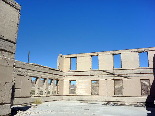
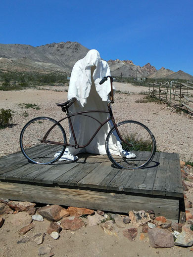
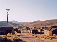
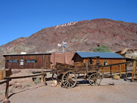
There are only around ten significant structures yet the site is very evocative, the crumbling remains set against a backdrop of stark desert hills, and the town includes what is said to be the most photographed ruin in Nevada, the Cook Bank. Many of the other buildings were either broken up to be used for new construction projects, or moved to nearby Beatty. Despite the relatively high visitation and easy access, being just off busy NV 375 between Beatty and Death Valley National Park, Rhyolite is free to enter, administered by the BLM and not commercialized; only a few fences around some of the more unstable buildings detract from the authenticity. The south edge of Rhyolite is also the location of Goldwell Open Air Museum, a collection of sculpture by various artists including Albert Szukalski from Belguim.
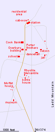
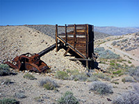
Rhyolite is well signposted from US 95 and NV 374 to Death Valley, and reached by a paved road, hence the regular stream of visitors. The side road climbs a little into a valley between the volcanic, mineralized peaks of the Bullfrog Hills, which show much evidence of the former mining operations, then passes a small (free) museum that also acts as an information center. The next half mile leads through the historic district, until the pavement ends, at the edge of the residential area, from where the road becomes rougher, curving back down to NV 374. Lesser buildings are found along side tracks to the east, and much of the ground is strewn with pieces of glass, iron and masonry, from the hundreds of other houses that once stood here. Signs warn against collecting artefacts, and other notices give information about the history of the main buildings.
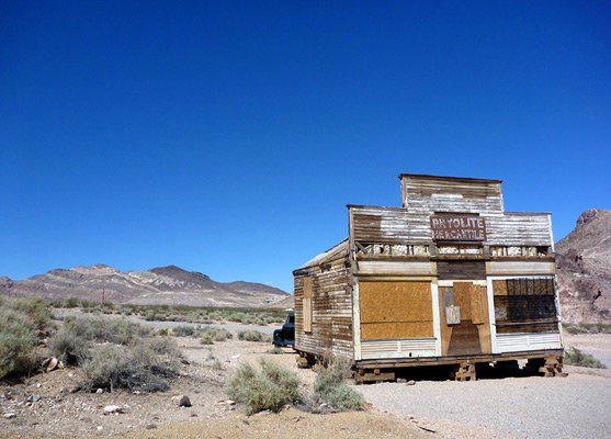
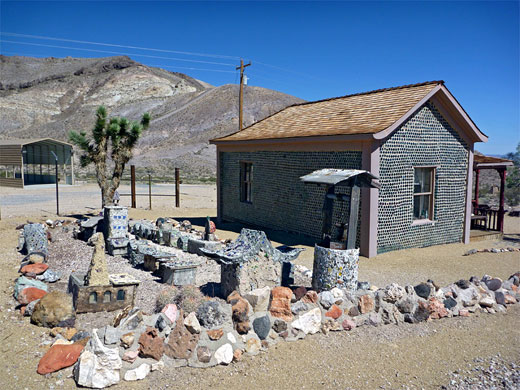
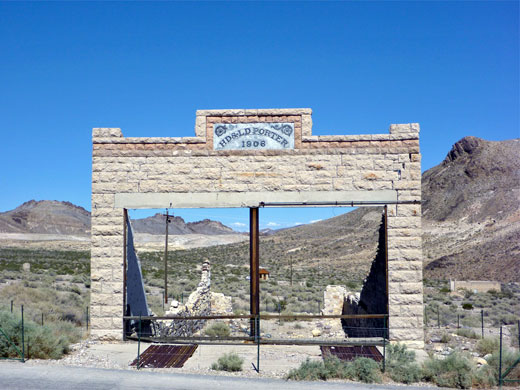
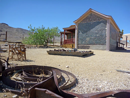
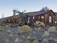
Just beyond the museum are a few ruined dwellings dating from the 1930s, including the Moffat house, but the first original site is a little further, on the east side of the road - the Rhyolite Mercantile store (severely damaged by a lightning-induced fire in September 2014), several outbuildings and a bottle house, which has a collection of glass-based artwork in the garden. The store started life as a jail, positioned right next to the road, and has been moved several times over the last century, gradually loosing parts of its exterior. The bottle house was built around 1905 by Tom Kelly - the largest of three such houses in town, using about 30,000 bottles - and has been kept in a good state of repair ever since, the most recent reconstruction being in 2005. Next, on the west side of the road, are the concrete walls of the 8 room schoolhouse, lacking the roof but lined by nearly complete exterior walls. This is followed by a smaller ruin (Overbury building), remains of what was a substantial, three floor structure used for offices. Opposite stands the front wall of the Porter Brothers store, signed 'HD & LD Porter, 1906'.
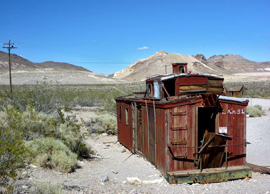
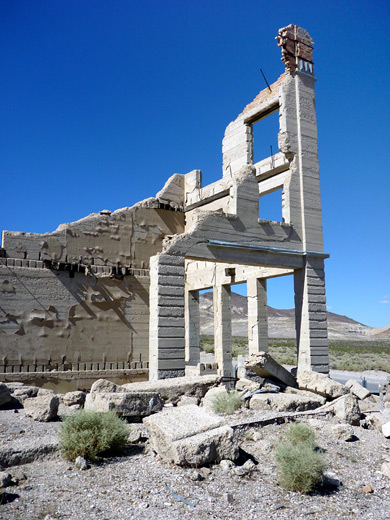
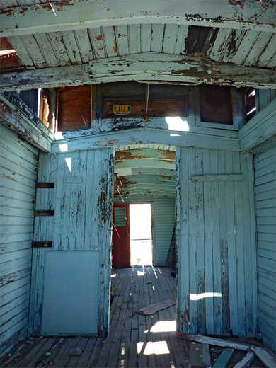
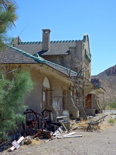
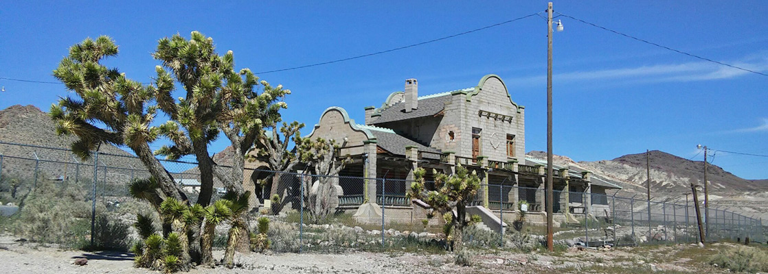
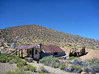
The three story Cook Bank building is just beyond, also concrete but more degraded than the school, with irregular walls, minus all the upper floors, and reaching near full height only at two corners, which are topped by fragments of more ornate brickwork. This stark, jagged ruin, once the largest and most expensive structure in town is certainly the most photogenic of the remaining ruins. The paved road ends not far beyond beside the fenced off railway station, of wood and stone construction and appearing largely intact. The station was built in 1908 for a branch line of the Las Vegas and Tonopah Railroad Company, and another rail relic stands nearby - an old Union Pacific caboose (subsequently used as a gas station), its interior covered by flaky blue paint - another good photographic subject. The railway line was removed in 1917, since when the station building has at various times been a guest house, bar, church and casino, hence the 'Rhyolite Ghost Casino' sign at the front.
The town declined rapidly after the brief boom and was largely abandoned by the early 1920s; most of the buildings are now completely gone and just a few of the larger establishments remain, in various stages of dereliction, though Rhyolite was never completely deserted, and today has a population of 20 or so, who help maintain the surviving remnants.
There are only around ten significant structures yet the site is very evocative, the crumbling remains set against a backdrop of stark desert hills, and the town includes what is said to be the most photographed ruin in Nevada, the Cook Bank. Many of the other buildings were either broken up to be used for new construction projects, or moved to nearby Beatty. Despite the relatively high visitation and easy access, being just off busy NV 375 between Beatty and Death Valley National Park, Rhyolite is free to enter, administered by the BLM and not commercialized; only a few fences around some of the more unstable buildings detract from the authenticity. The south edge of Rhyolite is also the location of Goldwell Open Air Museum, a collection of sculpture by various artists including Albert Szukalski from Belguim.
Orientation
Rhyolite is well signposted from US 95 and NV 374 to Death Valley, and reached by a paved road, hence the regular stream of visitors. The side road climbs a little into a valley between the volcanic, mineralized peaks of the Bullfrog Hills, which show much evidence of the former mining operations, then passes a small (free) museum that also acts as an information center. The next half mile leads through the historic district, until the pavement ends, at the edge of the residential area, from where the road becomes rougher, curving back down to NV 374. Lesser buildings are found along side tracks to the east, and much of the ground is strewn with pieces of glass, iron and masonry, from the hundreds of other houses that once stood here. Signs warn against collecting artefacts, and other notices give information about the history of the main buildings.
Map of Rhyolite
Ruins at Rhyolite
Just beyond the museum are a few ruined dwellings dating from the 1930s, including the Moffat house, but the first original site is a little further, on the east side of the road - the Rhyolite Mercantile store (severely damaged by a lightning-induced fire in September 2014), several outbuildings and a bottle house, which has a collection of glass-based artwork in the garden. The store started life as a jail, positioned right next to the road, and has been moved several times over the last century, gradually loosing parts of its exterior. The bottle house was built around 1905 by Tom Kelly - the largest of three such houses in town, using about 30,000 bottles - and has been kept in a good state of repair ever since, the most recent reconstruction being in 2005. Next, on the west side of the road, are the concrete walls of the 8 room schoolhouse, lacking the roof but lined by nearly complete exterior walls. This is followed by a smaller ruin (Overbury building), remains of what was a substantial, three floor structure used for offices. Opposite stands the front wall of the Porter Brothers store, signed 'HD & LD Porter, 1906'.
Cook Bank and the Railway Station
The three story Cook Bank building is just beyond, also concrete but more degraded than the school, with irregular walls, minus all the upper floors, and reaching near full height only at two corners, which are topped by fragments of more ornate brickwork. This stark, jagged ruin, once the largest and most expensive structure in town is certainly the most photogenic of the remaining ruins. The paved road ends not far beyond beside the fenced off railway station, of wood and stone construction and appearing largely intact. The station was built in 1908 for a branch line of the Las Vegas and Tonopah Railroad Company, and another rail relic stands nearby - an old Union Pacific caboose (subsequently used as a gas station), its interior covered by flaky blue paint - another good photographic subject. The railway line was removed in 1917, since when the station building has at various times been a guest house, bar, church and casino, hence the 'Rhyolite Ghost Casino' sign at the front.
Rhyolite Ghost Town - Similar Hikes
All Contents © Copyright The American Southwest | Comments and Questions | Contribute | Affiliate Marketing Disclosure | Site Map