Jubilee Mountain, Death Valley National Park
California > Death Valley National Park > The South > Jubilee Mountain
Jubilee Mountain
Off-trail hike to the summit of a peak in the Black Mountains, towards the south end of Death Valley, mostly along a stony ridge
Length: 1.1 miles
Elevation change: 1,252 feet
Difficulty: Moderate; steep in parts, and, loose stones underfoot
Type: One-way route
Usage: Low
Season: Fall, winter, spring
Trailhead: Jubilee Pass, along Hwy 178
Rating (1-5): ★★★★★
Elevation change: 1,252 feet
Difficulty: Moderate; steep in parts, and, loose stones underfoot
Type: One-way route
Usage: Low
Season: Fall, winter, spring
Trailhead: Jubilee Pass, along Hwy 178
Rating (1-5): ★★★★★

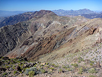
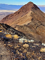
Jubilee Mountain is an 2,545 foot peak towards the south end of the Black Mountains, the somber, dark-colored range that borders the east side of Death Valley for over 50 miles, all formed of a complex mix of metamorphic rocks including gneiss, mica, schist, quartzite and migmatite.
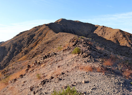
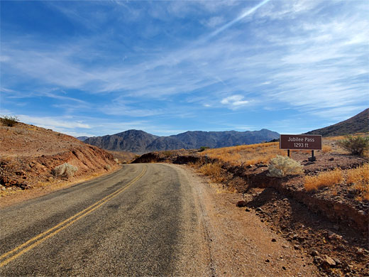
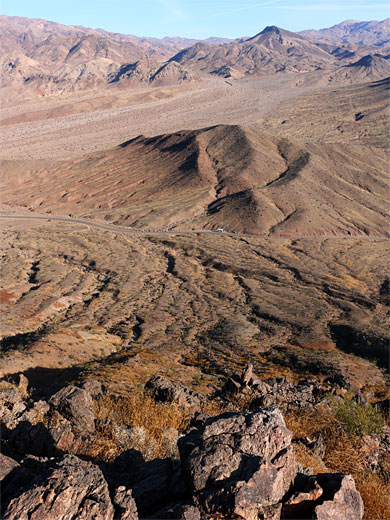
The peak sits just south of Jubilee Pass, 1,293 feet, the high point of the southern approach road to the valley, Hwy 178 from Shoshone; the summit therefore is 1,252 feet above the road, and 1.1 miles distant, and it may be reached by a relatively easy off-trail hike, steep in just a few places, the only potential difficulty being many loose stones on the slopes. The route is not marked, but obvious, all along a sloping ridgeline, over rocky, very lightly-vegetated terrain.
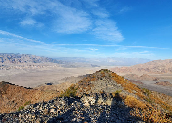
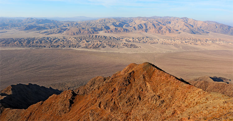
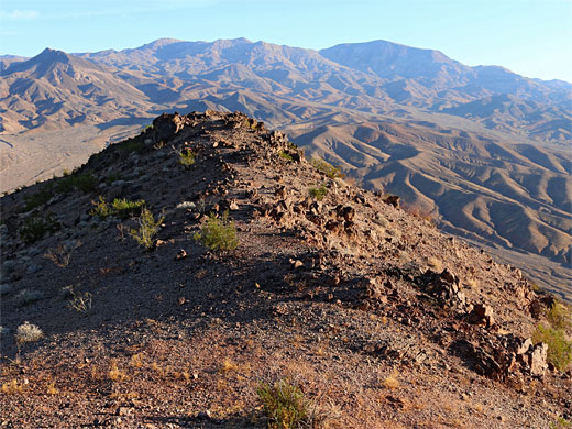
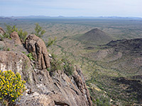
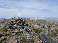
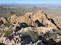
The summit of Jubilee Mountain is marked with a USGS plaque and is nearly flat for a few hundred feet, and since there are no higher peaks for some distance in all directions it gives fantastic views, of many other mountains to the east, and across Death Valley to the west, beyond which is a vast expanse of particularly remote, trailless land towards the south end of the park, centered on the Owlshead Mountains.
Jubilee Mountain is named after the pass, which was once known as Suicide Pass due to the death of a miner (Chester Pray) at this location in the early 1900s, whilst involved in the building of the road, though some think he was murdered. The name was changed to Jubilee, around 1913, simply to be less forbidding; the word seems to have no particular significance.
Map of Death Valley National Park and surroundings.
18 views of Jubilee Mountain.
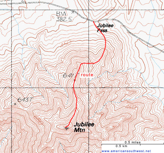
Primitive camping is possible in several places near Jubilee Pass, such as along a track (Virgin Spring Road) a short distance west. The wide gravelly verge at the pass provides a place to park, below the north face of Jubilee Mountain, which forms a ridge, extending northeastwards. The easiest route is to head towards the end of this ridge then simply follow it to the summit - starting across flattish ground then briefly rather steep, climbing about 300 feet, levelling out for a while and steep again up to a minor intermediate hill, Peak 2103, after 0.6 miles. The ridge continues with a mix of short climbs and more level sections, becoming gradually rockier, with more loose stones, up to the final, extended summit. Near the USGS marker is a trail register which on average records one name every couple of months. The best views of Death Valley are only right at the end, since most is hidden by the slopes on the climb. Vegetation all over the mountain is very limited, with desert trumpet perhaps the most widespread plant; there are no cacti or large shrubs.
The peak sits just south of Jubilee Pass, 1,293 feet, the high point of the southern approach road to the valley, Hwy 178 from Shoshone; the summit therefore is 1,252 feet above the road, and 1.1 miles distant, and it may be reached by a relatively easy off-trail hike, steep in just a few places, the only potential difficulty being many loose stones on the slopes. The route is not marked, but obvious, all along a sloping ridgeline, over rocky, very lightly-vegetated terrain.
The summit of Jubilee Mountain is marked with a USGS plaque and is nearly flat for a few hundred feet, and since there are no higher peaks for some distance in all directions it gives fantastic views, of many other mountains to the east, and across Death Valley to the west, beyond which is a vast expanse of particularly remote, trailless land towards the south end of the park, centered on the Owlshead Mountains.
Jubilee Mountain is named after the pass, which was once known as Suicide Pass due to the death of a miner (Chester Pray) at this location in the early 1900s, whilst involved in the building of the road, though some think he was murdered. The name was changed to Jubilee, around 1913, simply to be less forbidding; the word seems to have no particular significance.
Location
Map of Death Valley National Park and surroundings.
Photographs
18 views of Jubilee Mountain.
Jubilee Mountain Video
The Hike
Primitive camping is possible in several places near Jubilee Pass, such as along a track (Virgin Spring Road) a short distance west. The wide gravelly verge at the pass provides a place to park, below the north face of Jubilee Mountain, which forms a ridge, extending northeastwards. The easiest route is to head towards the end of this ridge then simply follow it to the summit - starting across flattish ground then briefly rather steep, climbing about 300 feet, levelling out for a while and steep again up to a minor intermediate hill, Peak 2103, after 0.6 miles. The ridge continues with a mix of short climbs and more level sections, becoming gradually rockier, with more loose stones, up to the final, extended summit. Near the USGS marker is a trail register which on average records one name every couple of months. The best views of Death Valley are only right at the end, since most is hidden by the slopes on the climb. Vegetation all over the mountain is very limited, with desert trumpet perhaps the most widespread plant; there are no cacti or large shrubs.
Jubilee Mountain Topographic Map
Jubilee Mountain - Similar Hikes
All Contents © Copyright The American Southwest | Comments and Questions | Contribute | Affiliate Marketing Disclosure | Site Map