Dead Wash Overlook Trail, Petrified Forest National Park
Arizona > Petrified Forest National Park > Hiking > Dead Wash Overlook Trail

Dead Wash Overlook Trail
Primitive route across badlands, past scattered rock formations, petrified wood and a few petroglyphs, into a valley then up to the rim of a mesa, overlooking a large area of flat land to the east
Length: 1.8 miles
Elevation change: 300 feet
Difficulty: Easy to moderate
Type: One way, semi-maintained trail
Usage: Low
Season: Spring, summer, fall
Trailhead: Gravel pullout on the east side of the park road, 0.8 miles south of I-40
Rating (1-5): ★★★★★
Elevation change: 300 feet
Difficulty: Easy to moderate
Type: One way, semi-maintained trail
Usage: Low
Season: Spring, summer, fall
Trailhead: Gravel pullout on the east side of the park road, 0.8 miles south of I-40
Rating (1-5): ★★★★★

Dead Wash is a usually dry drainage towards the north side of Petrified Forest National Park, a tributary of the Puerco River, and was so-named not for being barren and lifeless, although it is, instead because a miner was found dead here by his companion, in 1897.
The wash lies in an often overlooked section of the park, consisting mostly of flat grassland, between the scenic badlands north of I-40, and the main petrified wood area to the south, and so the 1.8 mile Dead Wash Overlook Trail sees very few visitors. This hike is a cross-country route rather than a marked path, one of the park's 'off the beaten track' routes, though unlike some others the way is not marked at all, so a topo map is necessary.
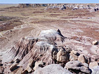
The final overlook, at the east edge of a low mesa, is impressive, though lacking any particularly distinctive features, and the hike to this point is also somewhat nondescript, passing just a few large petrified logs, not particularly colorful, plus scattered photogenic rock formations, and at least one petroglyph panel. The elevation change is small and the 3.6 mile round trip takes two hours at most.
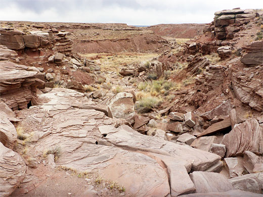
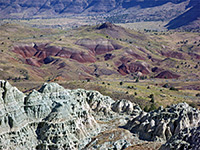
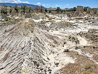
The Dead Wash Overlook hike starts at an unmarked parking area on the east side of the park road, with space for just three or four vehicles, 1.8 miles south of the I-40 crossing and 19 miles north of Rainbow Forest Museum. The surroundings are flat prairie, with no fossils or exposed rocks anywhere near. The route, barely evident even at the start, is due east across the grassy flat for a third of a mile to the rim of a low escarpment, below which the Petrified Forest Member of the Chinle Formation is exposed; undulating badlands, strewn with occasional petrified logs, some quite long. The route descends a little then turns northeast, now staying fairly level, following the band of mounds and little ravines for about half a mile, until a fence approaches ahead; this is a former park boundary, before lands to the north were added.
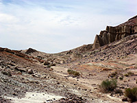
An A-shaped gate in the fence allows hikers to pass through, whereupon the route bends to the southeast and soon enters a minor drainage which initially is lined by low reddish slopes then drops down more steeply, through a band of rocks, becoming filled with boulders for a few hundred feet, until it reaches a wide basin, again with a few reddish mounds; one is quite distinctive, an isolated hill of maroon clay, just east of a streambed. Shortly before this, on a south-facing cliff along the lower edge of the rocky section, is a small petroglyph panel consisting of two well-drawn lizards, a horned lizard with round body and more common spiny lizard with elongated body.
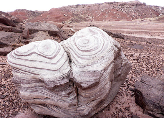
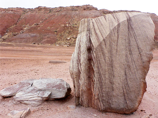
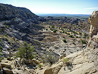
The route continues across the basin, past some photogenic stripy boulders, brown and white, apparently known as 'ice cream rocks'. The last section of the hike is across to the far side of the basin, up another bouldery slope to the top of a narrow mesa, and over to the far side, the final overlook. Ahead, most of the land is flat though Blue Mesa is in view to the south, and the ATSF railway line can just be discerned, close to the Puerco River.
The wash lies in an often overlooked section of the park, consisting mostly of flat grassland, between the scenic badlands north of I-40, and the main petrified wood area to the south, and so the 1.8 mile Dead Wash Overlook Trail sees very few visitors. This hike is a cross-country route rather than a marked path, one of the park's 'off the beaten track' routes, though unlike some others the way is not marked at all, so a topo map is necessary.
The final overlook, at the east edge of a low mesa, is impressive, though lacking any particularly distinctive features, and the hike to this point is also somewhat nondescript, passing just a few large petrified logs, not particularly colorful, plus scattered photogenic rock formations, and at least one petroglyph panel. The elevation change is small and the 3.6 mile round trip takes two hours at most.


Petrified Wood
The Dead Wash Overlook hike starts at an unmarked parking area on the east side of the park road, with space for just three or four vehicles, 1.8 miles south of the I-40 crossing and 19 miles north of Rainbow Forest Museum. The surroundings are flat prairie, with no fossils or exposed rocks anywhere near. The route, barely evident even at the start, is due east across the grassy flat for a third of a mile to the rim of a low escarpment, below which the Petrified Forest Member of the Chinle Formation is exposed; undulating badlands, strewn with occasional petrified logs, some quite long. The route descends a little then turns northeast, now staying fairly level, following the band of mounds and little ravines for about half a mile, until a fence approaches ahead; this is a former park boundary, before lands to the north were added.

Petroglyphs
An A-shaped gate in the fence allows hikers to pass through, whereupon the route bends to the southeast and soon enters a minor drainage which initially is lined by low reddish slopes then drops down more steeply, through a band of rocks, becoming filled with boulders for a few hundred feet, until it reaches a wide basin, again with a few reddish mounds; one is quite distinctive, an isolated hill of maroon clay, just east of a streambed. Shortly before this, on a south-facing cliff along the lower edge of the rocky section, is a small petroglyph panel consisting of two well-drawn lizards, a horned lizard with round body and more common spiny lizard with elongated body.
The Overlook
The route continues across the basin, past some photogenic stripy boulders, brown and white, apparently known as 'ice cream rocks'. The last section of the hike is across to the far side of the basin, up another bouldery slope to the top of a narrow mesa, and over to the far side, the final overlook. Ahead, most of the land is flat though Blue Mesa is in view to the south, and the ATSF railway line can just be discerned, close to the Puerco River.
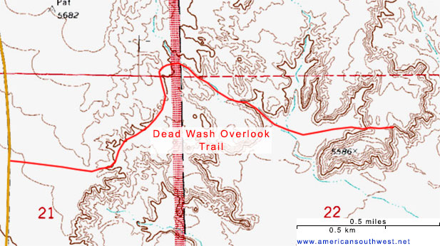
Topographic Map of the Trail
Dead Wash Overlook Trail - Similar Hikes
All Contents © Copyright The American Southwest | Comments and Questions | Contribute | Affiliate Marketing Disclosure | Site Map