Mystic Falls Trail, Yellowstone National Park
Wyoming > Yellowstone National Park > The Southwest > Hiking > Mystic Falls Trail
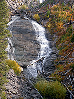
Mystic Falls
Popular loop hike, best in the clockwise direction; up a narrow ravine to a dramatic waterfall and some hidden hot springs, along a wooded plateau to a viewpoint of the Firehole River valley, then steeply down back to the trailhead
Length: 3 miles, round trip
Elevation change: 550 feet
Difficulty: Easy to moderate
Type: Loop. Two junctions en route, with the Summit Lake and Fairy Creek trails
Usage: Medium
Season: Summer, fall
Trailhead: Biscuit Basin
Rating (1-5): ★★★★★
Elevation change: 550 feet
Difficulty: Easy to moderate
Type: Loop. Two junctions en route, with the Summit Lake and Fairy Creek trails
Usage: Medium
Season: Summer, fall
Trailhead: Biscuit Basin
Rating (1-5): ★★★★★

Two little traveled, long distance paths start at Biscuit Basin, at the north edge of Upper Geyser Basin - the 13 mile Fairy Creek Trail and the Summit Lake Trail, which crosses the remote Madison Plateau and ends after 16 miles at Yellowstone's western boundary. But there is also one shorter and more popular hike, taking at most a couple of hours. The 3 mile loop to Mystic Falls and Biscuit Basin Overlook encounters varied river, forest and plateau scenery, and has a moderate elevation change of 550 feet.
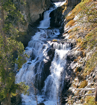
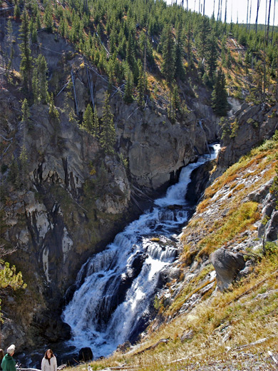
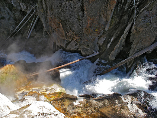
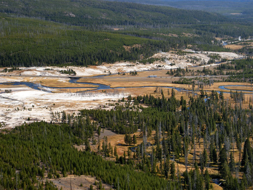
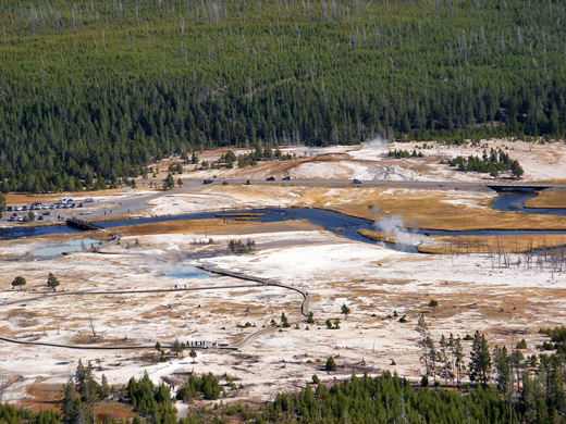
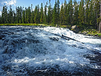
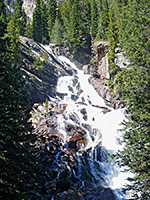
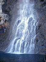
The falls are a spectacular cascade formed at a steep, narrow place in the canyon of the Little Firehole River, while the overlook has a fine view not only of the basin but also of several miles of the Firehole River valley, with Upper Geyser Basin in the distance. The loop hike is best done in the clockwise direction, visiting the falls first, since the elevation gain (up the river canyon) is more gentle, and the overlook appears suddenly and dramatically, rather than approaching gradually during the steep climb from the flat lands below.
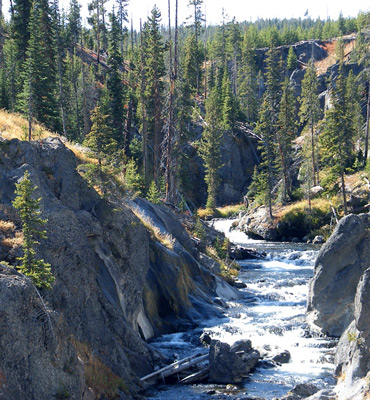
From the west side of the boardwalk loop across Biscuit Basin, the trail enters the pine forest, passes an information board and route map then climbs over a small, treeless ridge, completely burnt in the 1988 wildfires. The path forks at the start of the loop section; turning left, after a second junction (with the Summit Lake Trail), it enters the lower end of the Little Firehole River canyon and starts to climb the lightly forested slopes on the north side, looking down on the swift-flowing river below. This part is not too steep but the path is soon quite high above the river and it isn't long until Mystic Falls are first sighted. Notices warn of not straying from the trail for a closer look, but the views from the path are good, with just a few trees in the way. The 70 foot waterfall is a powerful whitewater cascade rather then a single drop, situated in a shady, sheer-walled, boulder-filled section of the canyon. There are two other good overlooks of the falls as the path continues to climb, now without any trees at all to block the scene.
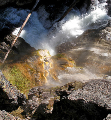
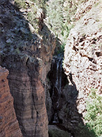
The route curves back slightly to a promontory near the top of the cascade, from where a short, hiker-made path winds down the steep slopes to the top of the cliffs immediately above the falls, revealing several small hot springs right on the river banks. They discharge boiling, sulfurous water, trickling down short but colorful channels edged by yellow algae. Above this point, the main path moves out of sight of the shallower upper canyon, which is still narrow, rocky and sheer-sided, before climbing to the top of the plateau that borders the river to the north. This is covered with bushes and small, new growth trees, all the original forest having been destroyed in 1988.
Another junction approaches, with the Fairy Creek Trail. The Mystic Falls loop turns right (east) and stays level for a while then descends gradually to the plateau edge, where the land drops away vertically by 200 feet. The rim offers far-reaching views of Biscuit Basin, of the nearby meanders of the Firehole River and of Upper Geyser Basin to the south. Steam plumes reveal various other hidden hot springs at the foot of the hills bordering the west side of the river. The final section of the path down the cliff face is steep and exposed, switchbacking across ashen slopes of loose soil and embedded boulders, though the descent is relatively short, and the path soon arrives back at the junction near the Biscuit Basin boardwalk.
The falls are a spectacular cascade formed at a steep, narrow place in the canyon of the Little Firehole River, while the overlook has a fine view not only of the basin but also of several miles of the Firehole River valley, with Upper Geyser Basin in the distance. The loop hike is best done in the clockwise direction, visiting the falls first, since the elevation gain (up the river canyon) is more gentle, and the overlook appears suddenly and dramatically, rather than approaching gradually during the steep climb from the flat lands below.
Mystic Falls
From the west side of the boardwalk loop across Biscuit Basin, the trail enters the pine forest, passes an information board and route map then climbs over a small, treeless ridge, completely burnt in the 1988 wildfires. The path forks at the start of the loop section; turning left, after a second junction (with the Summit Lake Trail), it enters the lower end of the Little Firehole River canyon and starts to climb the lightly forested slopes on the north side, looking down on the swift-flowing river below. This part is not too steep but the path is soon quite high above the river and it isn't long until Mystic Falls are first sighted. Notices warn of not straying from the trail for a closer look, but the views from the path are good, with just a few trees in the way. The 70 foot waterfall is a powerful whitewater cascade rather then a single drop, situated in a shady, sheer-walled, boulder-filled section of the canyon. There are two other good overlooks of the falls as the path continues to climb, now without any trees at all to block the scene.
Hot Springs
The route curves back slightly to a promontory near the top of the cascade, from where a short, hiker-made path winds down the steep slopes to the top of the cliffs immediately above the falls, revealing several small hot springs right on the river banks. They discharge boiling, sulfurous water, trickling down short but colorful channels edged by yellow algae. Above this point, the main path moves out of sight of the shallower upper canyon, which is still narrow, rocky and sheer-sided, before climbing to the top of the plateau that borders the river to the north. This is covered with bushes and small, new growth trees, all the original forest having been destroyed in 1988.
Biscuit Basin Overlook
Another junction approaches, with the Fairy Creek Trail. The Mystic Falls loop turns right (east) and stays level for a while then descends gradually to the plateau edge, where the land drops away vertically by 200 feet. The rim offers far-reaching views of Biscuit Basin, of the nearby meanders of the Firehole River and of Upper Geyser Basin to the south. Steam plumes reveal various other hidden hot springs at the foot of the hills bordering the west side of the river. The final section of the path down the cliff face is steep and exposed, switchbacking across ashen slopes of loose soil and embedded boulders, though the descent is relatively short, and the path soon arrives back at the junction near the Biscuit Basin boardwalk.
Mystic Falls Trail - Similar Hikes
All Contents © Copyright The American Southwest | Comments and Questions | Contribute | Affiliate Marketing Disclosure | Site Map