Hiking in Yellowstone National Park - the North
Wyoming > Yellowstone National Park > The North > Hiking
North Yellowstone Trails: Day Hikes near Mammoth | Day Hikes near Tower | Backcountry Hikes
The Yellowstone hiking map indicates the location of each trail.
All paths in Yellowstone: North, East, Southeast, Southwest, Northwest.

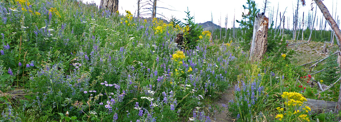
North Yellowstone National Park Trails - Day Hikes near Mammoth Hot Springs
Beaver Ponds Length 5.0 miles (8 km) (loop) Elevation change 450 feet (137 meters) Trailhead Beside Hymen Terrace Rating (1-5) ★★★★★ The pleasant trail to a group of beaver-inhabited ponds north of Mammoth village has two trailheads 1/4 mile apart, one near Liberty Cap, the other at the end of the old Gardiner High Road, next to Mammoth Hotel. The clockwise loop starts by a steepish climb through fir and spruce trees along Clematis Creek then forks north (straight on leads to the Sepulcher Mountain Loop Trail) across the foothills of Sepulcher Mountain, the route now mostly level, to the ponds. The return is at a lower elevation, through an area often frequented by elk, moose and deer. |
Blacktail Deer Creek Length 3.5 miles (5.6 km) Elevation change 1100 feet (335 meters) Trailhead Small pullout on the north side of the Grand Loop Road Rating (1-5) ★★★★★ Blacktail Deer Creek provides the main access into the Black Canyon of the Yellowstone River from the south. Most of the trail crosses relatively open ground with grassy meadows and patches of woodland though the last part is steep, down a narrow ravine as it approaches the river, which is crossed on a footbridge. On the far side the path joins the Yellowstone River Trail, close to Crevice Lake and 3 primitive campsites. The trailhead is 7 miles east of Mammoth. |
Bunsen Peak Length 4 miles (6.4 km) Elevation change 1380 feet (421 meters) Trailhead West end of the disused Bunsen Peak Road Rating (1-5) ★★★★★ Bunsen Peak, a circular, solitary, volcanic summit, affords excellent views of the Mammoth area and the surrounding mountains. Starting from the main road just south of its descent into Golden Gate Canyon, a 2 mile trail winds up the partially wooded west side to the summit, then continues 2 more miles down the east slope to the disused Bunsen Peak Road. From here the trailhead is 3 miles west. The full route over the peak could be combined with a trip to Osprey Falls for a 9 mile round trip. |
|
Clagett Butte Length 1 miles (1.6 km) Elevation change 240 feet (73 meters) Trailhead Grand Loop Road, near the Upper Terraces Rating (1-5) ★★★★★ The short Clagett Butte Trail links the busier paths to Snow Pass and Sepulcher Mountain, climbing from two wooded valleys to an open, grassy plateau, and is sometimes used as part of a loop hike to the mountain. |
| Tours of the Lamar Valley |
|
Lava Creek Length 3.5 miles (5.6 km) Elevation change 800 feet (244 meters) Trailhead Beside the Gardner River Rating (1-5) ★★★★★ Lava Creek is a tributary of the Gardner River, forming quite a steep, narrow canyon southeast of Mammoth. The Grand Loop Road follows close to the rim and offers some views, though much better is the moderately easy trail running by the creek. The southern trailhead is where Lava Creek is crossed by the loop road, while the north end is along a side road leading to the Gardner River near Mammoth school. En route are 50 foot Undine Falls, several springs and a few beaver ponds. |
Lower Terraces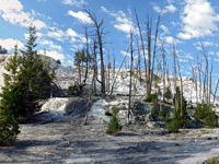 Length 1 miles (1.6 km) loop Elevation change 200 feet (61 meters) Trailhead Parking area along the main road (US 89) Rating (1-5) ★★★★★ The main attraction in the Mammoth area is the hot springs and their travertine terraces, the lower part of which are easily toured via several short loop paths, either paved or boardwalk. The upper terraces are crossed by a narrow, lightly-traveled, one-way road, also suitable for walking; the hike here involves an additional 1.8 miles. |
|
Osprey Falls Length 3.5 miles (5.6 km) Elevation change 900 feet (274 meters) Trailhead West end of the disused Bunsen Peak Road Rating (1-5) ★★★★★ Half way along the unpaved Bunsen Peak Road, this trail follows the rim of the deep, narrow Sheepeater Canyon southwards then descends by means of switchbacks to Osprey Falls, where the Gardner River tumbles 150 feet, creating quite a lot of mist and spray. The actual trail is only 1 mile, but as the road is now closed to traffic, the hike must begin on the main highway, at the southern junction as that involves the least elevation change. |
|
Rescue Creek Length 7.5 miles (12.1 km) Elevation change 1320 feet (402 meters) Trailhead 7 miles east of Mammoth Rating (1-5) ★★★★★ This path begins at the Blacktail trailhead along the loop road, 7 miles east of Mammoth. The first 1.5 miles is across meadows and bushy land, past 2 junctions - left is a fragment of the Howard Eaton Trail that links with the Lava Creek route, right is the Blacktail Deer Creek Trail. Next is a steady ascent up Rescue Creek, across a semi-open ridge then a long descent along Turkey Pen Creek towards the Yellowstone River. The final section curves to the southwest, crosses the Gardner River and meets the main road once more, close to the north entrance station. |
Sepulcher Mountain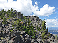 Length 7 miles (11.3 km) (loop) Elevation change 3360 feet (1024 meters) Trailhead Beside Hymen Terrace Rating (1-5) ★★★★★ Sepulcher is the highest peak in the Mammoth area, at 9,652 feet. The strenuous route to the top begins a mile along the path to Beaver Ponds - from here, the path continues its ascent up Clematis Creek then climbs to a ridge high above, following this northwards to the summit. The loop continues by descending the southern slopes into the valley of Glen Creek and on to the end of the Snow Pass Trail. Including the access trails, the full loop is 11 miles. |
Snow Pass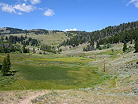 Length 2 miles (3.2 km) Elevation change 650 feet (198 meters) Trailhead Along the road through Mammoth's upper terrace Rating (1-5) ★★★★★ Beginning either along the one-way road through Mammoth's upper terrace, or a short distance south on the main road, the Snow Pass Trail climbs a steep, wooded hillside to the 7,450 foot pass, then down the far side a short distance to a junction with the Sepulcher Mountain and Fawn Pass trails. |
Wraith Falls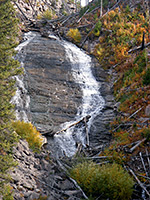 Length 0.3 miles (0.5 km) Elevation change 120 feet (37 meters) Trailhead Pullout on the south side of the Grand Loop Road Rating (1-5) ★★★★★ The very short route to 100 foot Wraith Falls starts a quarter mile east of the Lava Creek Picnic area, 5 miles from Mammoth. The drop is more of a cascade than a waterfall, as Lupine Creek flows over a steep cliff on its way to joining Lava Creek. The trail crosses a sagebrush meadow then runs alongside a small stream. |
North Yellowstone National Park Trails - Day Hikes near Tower and the Northeast
|
Garnet Hill Length 7.5 miles (12.1 km) (loop) Elevation change 300 feet (91 meters) Trailhead Tower Junction Rating (1-5) ★★★★★ The loop trail around Garnet Hill follows the eastern end of the Black Canyon of the Yellowstone River for 4 miles, with the return through woodland along Elk Creek and Lost Creek. The mouth of the canyon at the junction with the Lamar River is a good location to spot bison and elk. The two trailheads are 100 yards apart, just north of the crossroads at Tower Junction. |
Lost Lake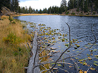 Length 4 miles (6.4 km) (loop) Elevation change 600 feet (183 meters) Trailhead Roosevelt Lodge Rating (1-5) ★★★★★ Starting right next to Roosevelt Lodge at Tower Junction, this loop trail climbs a wooded hillside and enters a hidden valley containing lily pad-covered Lost Lake, then follows Yancey Creek at the far side of the lake to a petrified redwood tree, which can also be reached by a short spur road branching off the main highway. From here, the return to the trailhead is due east, across a grassy hill. Near the start, a short side path leads to the 40 foot Lost Creek Falls. |
|
Roosevelt-Tower Length 2.5 miles (4 km) Elevation change 350 feet (107 meters) Trailhead Roosevelt Lodge Rating (1-5) ★★★★★ This trail provides an alternative route between Tower Junction and the campground at Tower Falls - from Roosevelt Lodge it climbs 300 feet quite steeply then traverses partially wooded hillsides above the main road, winding in and out of several small ravines. |
|
Tower Creek Length 4 miles (6.4 km) Elevation change 420 feet (128 meters) Trailhead Tower Creek campground Rating (1-5) ★★★★★ From Tower Creek campground, a straight, easy trail heads southwest along the north side of the creek for 4 miles, as far as the junction with Carnelian Creek. The stream is a good location for brook and rainbow trout, and the narrow canyon is quite scenic, though was quite badly affected by the fires of 1988. |
|
Tower Falls Length 0.4 miles (0.6 km) Elevation change 240 feet (73 meters) Trailhead Pull-out along the main road Rating (1-5) ★★★★★ The route to the base of 132 foot Tower Falls is short but steep and usually slippery. The lowest third is currently closed 'in the interest of public safety', according to the NPS, but the upper part still gives a good view of the top of the waterfall. |
|
Trout Lake Length 0.5 miles (0.8 km) Elevation change 100 feet (30 meters) Trailhead North side of the Grand Loop Road Rating (1-5) ★★★★★ Cutthroat trout are the main attraction of Trout Lake, appealing to bears as well as anglers. The lake has a scenic setting and is reached by an easy, unmarked trail through pine woodland starting a mile west of the Pebble Creek campsite. |
Yellowstone River Picnic Area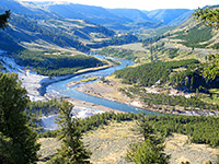 Length 2 miles (3.2 km) Elevation change 400 feet (122 meters) Trailhead Yellowstone River Picnic Area Rating (1-5) ★★★★★ This easy trail follows the east side of the cliffs at the downstream end of the Grand Canyon of the Yellowstone River, to a place known as The Narrows. Here the canyon is only 400 feet deep, much smaller than the 1,200 foot gorge witnessed from the more well known viewpoints at the upper end, but the views are still dramatic. After 2 miles the path reaches a 4-way junction - left and straight on is the Specimen Ridge Trail, while right is a one mile path that descends into the Grand Canyon to the site of the historic Bannock Indian Ford, opposite Tower Falls on the far side of the river. The path begins at the Yellowstone Picnic Area, 1.2 miles east of Tower Junction. |
North Yellowstone National Park Trails - Backcountry Hikes
|
Bighorn Pass Length 18 miles (29 km) Elevation change 1900 feet (579 meters) Trailhead Indian Creek campground Rating (1-5) ★★★★★ At 9,110 feet, Bighorn is one of the higher mountain passes in Yellowstone, and forms the half-way point of a lengthy cross-country trail linking Indian Creek campground, on the Grand Loop Road south of Mammoth, with US 191 west of the park boundary. From the east, the path starts by traversing several miles of forest and grassland beside Indian Creek before a steady climb up Panther Creek to the pass. Next is a steep but relatively short descent into the canyon of the upper Gallatin River, which soon levels out to a wide valley, lined with meadows, and usually containing much wildlife. Because of large numbers of bears around some parts of the trail, hiking may be subject to restrictions. |
|
Buffalo Plateau Length 16 miles (25.7 km) Elevation change 3100 feet (945 meters) Trailhead 2 miles along the Slough Creek Trail Rating (1-5) ★★★★★ The long path to and from the high country of Buffalo Plateau on the north edge of Yellowstone passes varied terrain of river valleys, open slopes, forest, meadows, marshland and rocky ridges. The western end is 2 miles down the path to Hellroaring Creek while the east trailhead is 2 miles along the Slough Creek Trail. The differing habitats harbor many kinds of wildlife. |
|
Cache Creek Length 14 miles (22.5 km) to Republic Pass Elevation change 3470 feet (1058 meters) Trailhead 3 miles down the Lamar River Trail Rating (1-5) ★★★★★ A long, remote valley in the northeast corner of Yellowstone, Cache Creek is a renowned backcountry fishing location, and also a likely place to see wolves. Most visitors just walk a few miles up the lower end, though the trail, which begins 3 miles down the Lamar River Trail, continues high into the mountains, exiting the park at 10,440 foot Republic Pass and meeting the highway 4 miles further at Cooke City. Half way along, the 3.5 mile Thunderer Cutoff Trail allows a shorter route back to the main road, across the north slopes of The Thunderer mountain. |
|
Coyote Creek Length 5 miles (8 km) to the park boundary Elevation change 1600 feet (488 meters) Trailhead 2 miles down the Hellroaring Creek Trail Rating (1-5) ★★★★★ Coyote Creek is a minor tributary of Hellroaring Creek, and provides an alternative route northwards into the Gallatin National Forest. The trail climbs steadily across open hillsides, follows the Coyote Creek valley for a while, and eventually reaches marshy land on Buffalo Plateau. |
|
Fan Creek Length 5.5 miles (8.8 km) Elevation change 750 feet (229 meters) Trailhead 1.8 miles east of US 191 Rating (1-5) ★★★★★ The Fan Creek trail is a connecting route between the Sportsman Lake and Fawn Pass routes, running through meadows and forest along the creek, which like most streams hereabouts is good for fishing. The path crosses the creek several times, is well used, and passes three backcountry campsites. |
|
Fawn Pass Length 17 miles (27.4 km) Elevation change 2000 feet (610 meters) Trailhead Along US 191 Rating (1-5) ★★★★★ One of three long cross-country routes in the northwest part of Yellowstone, the Fawn Pass Trail follows the valleys of Fan Creek, Fawn Creek and the upper Gardner River, and crosses several miles of mountainous terrain including around the 9,150 foot pass. The western trailhead is along US 191 just outside the park, while the east end is at a junction with the Snow Pass Trail, 2 miles from Mammoth village. The river valleys provide good habitat for grizzly bears, elk and moose. |
|
Hellroaring Creek Length 7.5 miles (12.1 km) to the park boundary Elevation change 650 feet (198 meters) Trailhead Short side track, 3.6 miles from Tower junction Rating (1-5) ★★★★★ The path along Hellroaring Creek is one of three starting near Tower Junction that exit the park and continue into the Gallatin National Forest. The trailhead for all is 3 miles north of Tower - the path descends to the Yellowstone River, crosses it on a bridge, passes a junction with the Buffalo Plateau/Coyote Creek trails (and another shortly after with the 17 mile Yellowstone River Trail) then follows the steep-sided, rocky, wooded valley of Hellroaring Creek northwards. Summer brings elk, bison and moose to the sagebrush meadows along the stream, though also quite hot conditions, as this is a relatively low elevation area. |
|
Pebble Creek Length 10.5 miles (16.9 km) Elevation change 1500 feet (457 meters) Trailhead Pebble Creek campground Rating (1-5) ★★★★★ The scenic, U-shaped valley of Pebble Creek has a typical mixture of wildflower meadows and pine/spruce forest, enclosed on both sides by mountains rising to over 10,000 feet. The path through the valley begins and ends at trailheads along the park road - west at the Pebble Creek Campground, east at a picnic area just over a mile from the northeast entrance station. Most of the route has only a gentle gradient, but the east section is quite steep, passing up and down a narrow ridge near the head of the valley. |
|
Slough Creek Length 9.5 miles (15.3 km) to the park boundary Elevation change 500 feet (152 meters) Trailhead Near the end of the road to Slough Creek campground Rating (1-5) ★★★★★ Slough Creek meanders through a wide, marshy valley in the far northwest of Yellowstone, joining the Lamar River a few miles east of Tower. The stream provides good fishing though other wildlife are not particularly common. An easy trail, formerly a wagon track, starts at the end of a spur road, cuts through woods for 2 miles then follows the east side of the valley all the way to the park boundary and beyond. On the way are two junctions; one with the Buffalo Plateau Trail, the other a route over Bliss Pass to Pebble Creek. |
|
Specimen Ridge Length 17 miles (27.4 km) Elevation change 3200 feet (975 meters) Trailhead Grand Loop Road, 2 miles east of Tower Junction Rating (1-5) ★★★★★ The strenuous and little-used trail along Specimen Ridge, starting 2 miles east of Tower Junction, climbs to the summit of 9,614 foot Amethyst Mountain which affords panoramic views over the Lamar Valley to the northeast, Grand Canyon of the Yellowstone to the west, and Mirror Plateau to the south. The path continues more steeply down the east side of the peak and meets the Lamar River Trail 1.5 miles from the highway. The ridge is not renowned for wildlife and has no thermal areas, so the main attractions are the views, the solitude and also various petrified trees that are found scattered over the slopes. |
|
Sportsman Lake Length 20 miles (32.2 km) Elevation change 3200 feet (975 meters) Trailhead Beside US 191 Rating (1-5) ★★★★★ Sportsman Lake is the longest of the various trails across the high country in Yellowstone's northwest; including the connecting paths at the east end, the distance from road to road is 23 miles. It starts, in the west, next to the Gallatin River on US 191, and follows Specimen Creek for a few miles, across various other streams then climbs up to a pass high on the southern slopes of Electric Peak. From here the route descends to the upper end of the Gardner River, crosses a ridge, and leads down Glen Creek to a junction with the Sepulcher Mountain Trail, from where the Grand Loop Road is 3 miles east, via Snow Pass. Various other trails branch off, and a typical trip along the trail lasts for 3 to 4 days. |
|
Yellowstone River Length 17 miles (27.4 km) Elevation change 1150 feet (351 meters) Trailhead East side of Garndiner Rating (1-5) ★★★★★ Most of the Black Canyon of the Yellowstone River can be viewed from a long but not difficult trail that starts at the Hellroaring Trailhead, 3 miles north of Tower Junction, and ends in Gardiner. The eastern part descends through woodland to the river, crosses it on a suspension bridge then veers away for a while, over Hellroaring Creek and through more forested land beyond, but the remaining 14 miles are close to the canyon floor. All of the trail has a low elevation so has a longer use season than most other routes in the park, though in spring, high water from snowmelt can cause hazardous conditions. Camping, fishing and wildlife watching are the main attractions, in addition to simply experiencing the beauty of the deep, dark-walled canyon. Half way along is the junction with the path down Blacktail Deer Creek, allowing either the upper or lower sections of the river trail to be hiked as a relatively easy day trip. |
All Contents © Copyright The American Southwest | Comments and Questions | Contribute | Affiliate Marketing Disclosure | Site Map