Bunsen Peak Trail, Yellowstone National Park
Wyoming > Yellowstone National Park > The North > Hiking > Bunsen Peak Trail
Bunsen Peak
The summit of Bunsen Peak, an ancient cinder cone, gives excellent views of the Mammoth area and the surrounding mountains, and is reached by a steep trail up the partly wooded western slopes
Length: 2 miles
Elevation change: 1,380 feet
Difficulty: Moderate
Type: One way. Path continues down the east face of the peak, and a 7 mile loop can be made, returning via Bunsen Peak Road
Usage: Low to medium
Season: Spring, summer, fall
Trailhead: West end of the disused Bunsen Peak Road
Rating (1-5): ★★★★★
Elevation change: 1,380 feet
Difficulty: Moderate
Type: One way. Path continues down the east face of the peak, and a 7 mile loop can be made, returning via Bunsen Peak Road
Usage: Low to medium
Season: Spring, summer, fall
Trailhead: West end of the disused Bunsen Peak Road
Rating (1-5): ★★★★★

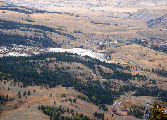
Several paths provide a good, elevated panorama over the Mammoth Hot Springs area near the north entrance to Yellowstone National Park, including the routes to Sepulcher Mountain and Snow Pass, but the shortest is the 2 mile trail to the top of Bunsen Peak - an isolated volcanic cone rising 1,400 feet above the surroundings, 3 miles south of Mammoth village.
The slopes are only lightly forested, and completely treeless in some parts, so the views are good from the start, initially of Golden Gate Canyon and lands to the west, becoming more panoramic near the 8,564 foot summit. The trail continues down the far (east) side of the peak and connects with another path to Osprey Falls; a loop back to the trailhead can be made by returning along the disused Bunsen Peak Road, which circles around three sides of the mountain.
Parking for the hike is by the side of the Grand Loop Road (Norris to Mammoth) at the junction with Bunsen Peak Road, just south of the start of the highway's descent into the upper end of Golden Gate Canyon. Space is quite limited, and the lot may fill up by lunchtime on busy summer days, as it is also used by hikers visiting Osprey Falls and Glen Creek/Snow Pass. Early visitors to Yellowstone National Park could drive along Bunsen Peak Road but it has been closed to private vehicles for many years as the route is too narrow for today's volume of traffic, so now the track is open for foot travel only, forming part of the 3.5 mile hike to Osprey Falls or the 9 mile loop across both sides of Bunsen Peak.
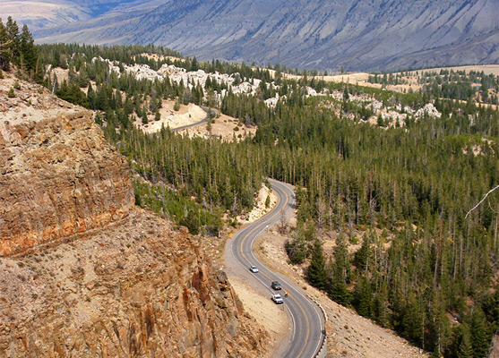
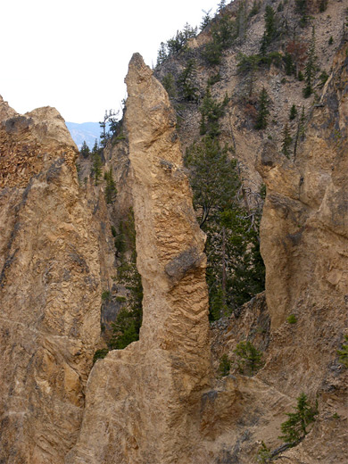
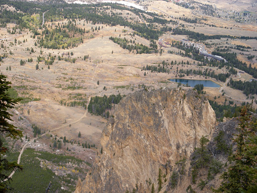
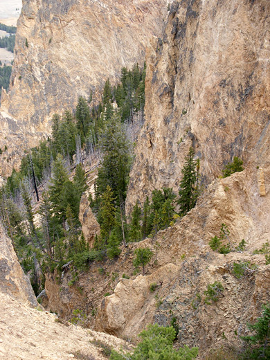
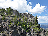
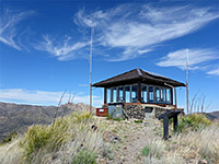
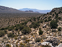
The two mile path to the summit of Bunsen Peak climbs a sagebrush-covered hillside and passes through a patch of post-1988 wildfire pine trees, gaining height steadily but not too steeply, then enters a flat basin filled with taller trees and some meadowland - the only level part of the journey. Not far beyond, the route approaches the edge of a cliff for a view of the highway as it curves through Kingman Pass at the narrow upper part of Golden Gate Canyon; beyond are the Gardner River valley and the long, straight west face of Mount Everts. The trail turns south into open sagebrush once more and ascends more steeply, swinging back north and passing some unusual, pointed, eroded travertine rock formations, and finally zig-zagging through increasingly stony surroundings to the summit, on which are built several NPS service buildings and communication masts.
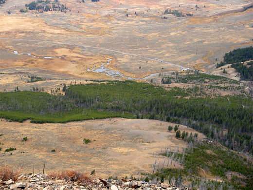
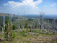
This exposed, windswept location still supports a few gnarled pine trees, but the views are essentially unobscured in all directions, and quite impressive even though some parts of the horizon (to the south) are distant and rather indistinct. Mammoth village is clearly visible to the north, with Gardiner several miles beyond, over the border in Montana, all framed by high mountains to the west, north and east, including the Absaroka, Gallatin, and Madison ranges. From the summit, the continuation path curves past a lesser peak just north then descends over land completely burnt in 1988 and still devoid of any trees, meeting the Bunsen Peak Road again after 2 miles.
The slopes are only lightly forested, and completely treeless in some parts, so the views are good from the start, initially of Golden Gate Canyon and lands to the west, becoming more panoramic near the 8,564 foot summit. The trail continues down the far (east) side of the peak and connects with another path to Osprey Falls; a loop back to the trailhead can be made by returning along the disused Bunsen Peak Road, which circles around three sides of the mountain.
Bunsen Peak Trailhead
Parking for the hike is by the side of the Grand Loop Road (Norris to Mammoth) at the junction with Bunsen Peak Road, just south of the start of the highway's descent into the upper end of Golden Gate Canyon. Space is quite limited, and the lot may fill up by lunchtime on busy summer days, as it is also used by hikers visiting Osprey Falls and Glen Creek/Snow Pass. Early visitors to Yellowstone National Park could drive along Bunsen Peak Road but it has been closed to private vehicles for many years as the route is too narrow for today's volume of traffic, so now the track is open for foot travel only, forming part of the 3.5 mile hike to Osprey Falls or the 9 mile loop across both sides of Bunsen Peak.
The Path
The two mile path to the summit of Bunsen Peak climbs a sagebrush-covered hillside and passes through a patch of post-1988 wildfire pine trees, gaining height steadily but not too steeply, then enters a flat basin filled with taller trees and some meadowland - the only level part of the journey. Not far beyond, the route approaches the edge of a cliff for a view of the highway as it curves through Kingman Pass at the narrow upper part of Golden Gate Canyon; beyond are the Gardner River valley and the long, straight west face of Mount Everts. The trail turns south into open sagebrush once more and ascends more steeply, swinging back north and passing some unusual, pointed, eroded travertine rock formations, and finally zig-zagging through increasingly stony surroundings to the summit, on which are built several NPS service buildings and communication masts.
Summit of Bunsen Peak
This exposed, windswept location still supports a few gnarled pine trees, but the views are essentially unobscured in all directions, and quite impressive even though some parts of the horizon (to the south) are distant and rather indistinct. Mammoth village is clearly visible to the north, with Gardiner several miles beyond, over the border in Montana, all framed by high mountains to the west, north and east, including the Absaroka, Gallatin, and Madison ranges. From the summit, the continuation path curves past a lesser peak just north then descends over land completely burnt in 1988 and still devoid of any trees, meeting the Bunsen Peak Road again after 2 miles.
Bunsen Peak Trail - Similar Hikes
All Contents © Copyright The American Southwest | Comments and Questions | Contribute | Affiliate Marketing Disclosure | Site Map