The American Southwest - Videos of Parks, Scenery and Wildlife
Videos are also available on Youtube.
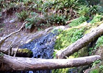
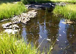
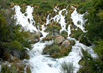
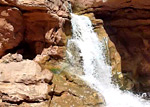
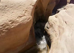
A brief view of one of the narrowest sections of Aravaipa Canyon, about 2.5 miles from the western trailhead, where the shallow, fast-flowing creek is bordered by vertical walls of reddish-grey Precambrian schist. Followed by a gila monster, walking beside the stream. (0:46 min)
Scenes along the Bright Angel Trail, from the Bright Angel trailhead to Plateau Point, including the 1.5 and 3 mile resthouses, Garden Creek, Indian Garden, the Tonto West trail junction and Plateau Point - a 12.6 mile round trip hike that took just less than 5 hours on a hot and sunny May day. (2:48 min; 42.7 mb)
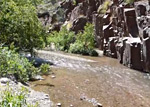
A few scenes in the granite narrows of Hance Creek, and of Sockdolager Rapids and the Colorado River, at the end of the canyon. Reached by a long hike starting with the Grandview Trail and a short section of the Tonto Trail. (1:04 min; 35 mb)
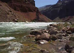
Hance Rapids on the Colorado River, at the end of the 8 mile New Hance Trail down Red Canyon - at river mile 77 in the Grand Canyon. (0:51 min; 6.8 mb)
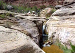
Three locations along the 8.5 mile Hermit Trail - a pool and waterfall in the lower narrows of Hermit Creek, Hermit Rapids on the Colorado River at the end of the trail, and a Grand Canyon rattlesnake on grassy slopes above the Tonto Bench. (1:07 min; 21 mb)
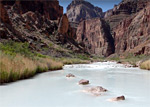
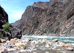
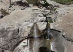
The Little Colorado River, a little way upstream and downstream of the end of Salt Trail Canyon, reached by the 3 mile Salt Trail. Also pools, cascades and an unusual travertine waterfall in the lower part of Big Canyon, which meets the river half a mile east. (2:22 min)
Eight scenes in the watery narrows of Pumphouse Wash, an upper tributary of Oak Creek - from the first pool near the trailhead, through the flooded slot canyon section, to the largest pool reached after nearly 3 miles, just past the junction with James Canyon. (0:54 min; 10.4 mb)
The largest pool along the 4.9 mile Woods Canyon Trail, south of Sedona; up to 300 feet long and 100 feet across, bordered by flat red slickrock of the Supai Formation. (1:12 min)
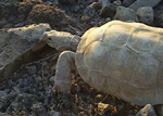
An aged desert tortoise at sunset in early summer, on the summit of Lost Horse Peak - a small hill near I-8 exit 140 in the Sonoran Desert National Monument of south central Arizona. (1:11 min; 9.4 mb)
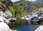
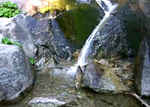
Pools and cascades near the East Fork confluence in Sabino Canyon - reached by a 3 mile hike along the Sabino Canyon Trail then a short walk cross-country to the creek. (0:44 min)
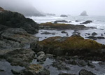
The rough, rocky, foggy coastline just south of Enderts Beach, at the edge of Del Norte Coast Redwoods State Park, in north California. South of this point, all of the shoreline is quite inaccessible, due to the very steep cliffs. (0:28 min; 5.6 mb)
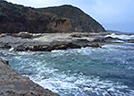
Six short scenes of waves breaking over jagged sandstone rocks along the Pacific coast in Harmony Headlands State Park, between Morro Bay and Cambria. The rocks range in color from black in the tidal zone to orange above the high water line, and many have the unusual weathering texture known as tafoni. (0:48 min; 33 mb)
Pools and cascades of Fern Falls, at the end of the 2.6 mile Boy Scout Tree Trail in Jedediah Smith Redwoods State Park. This location is just a quarter of a mile from the edge of the woods, so receives a little more sunlight hence the understory vegetation is denser and more varied than places deeper in the forest. (0:50 min)
Ella Falls is a small waterfall formed by Sequoia Creek as it flows down a steep granite hillside in the Grant Grove section of Kings Canyon National Park, reached by a 1.5 mile walk along the Sunset Trail starting from the Sunset Campground, or a slightly longer walk from the General Grant Tree. (0:31min; 6.1 mb)
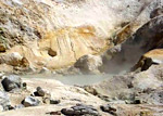
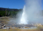
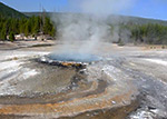
Some of the active geothermal features of Bumpass Hell in Lassen Volcanic National Park, including the largest hot spring in the basin (East Pyrite Pool), and the world's hottest fumarole (Big Boiler). (0:45 min; 9 mb)
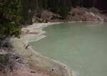
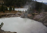
Boiling Springs Lake, in the Warner Valley section of Lassen Volcanic National Park: the lake itself, and several mud pots and vents around the edges. (0:56 min; 14 mb)
Reached by a 0.8 mile trail starting at the Kings Creek picnic area, Cold Boiling Lake is surrounded by trees and marshy grassland, with several small satellite pools, some of which bubble gently due to escaping carbon dioxide gas. (0:19 min; 3.6 mb)
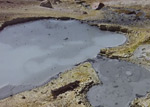
Devils Kitchen is a colorful group of hot springs, mud pots and fumaroles, along Hot Springs Creek in the Warner Valley section of Lassen Volcanic National Park. (1:15 min; 18 mb)
Eight short scenes of the cascades and falls along Kings Creek, reached by a 1.5 mile trail starting half way along the scenic drive (CA 89) through Lassen Volcanic National Park. (1:28 min; 17.4 mb)
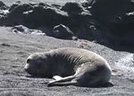
Several scenes of harbor seals on the black sand beach near Punta Gorda Lighthouse, along the Lost Coast of north California. This location is about 3 miles south of Mattole Beach, which is the start point for the 24 mile trail to Shelter Cove towards the south end of the coast. (mp4; 1:04 min; 12.2 mb).
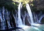
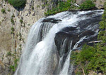
The segmented, 100 foot cascades of Burney Falls - the main attraction of McArthur-Burney Falls Memorial State Park in north California. Below the falls is a deep, blue pool, from where Burney Creek flows one more mile before joining Lake Britton (0:39 min; 7.6 mb).
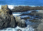
Three brief scenes showing waves breaking over eroded, thin-layered rocks in Montaña de Oro State Park, along the Pacific coast south of Morro Bay. This location is near Hazard Reef, the northernmost section of the rocky coast in the park; beyond this the shoreline is sandy (0:48 min; 22 mb).
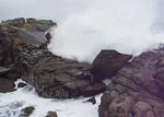
Fierce waves breaking over the eroded sandstone rocks in the northern part of Salt Point State Park, on the Pacific coast of Sonoma County, north California (1:26 min; 21.6 mb)
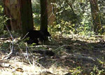
This short, shaky video shows a young black bear scratching against a tree, at the edge of a meadow alongside the Sunset Rock Trail, in the Giant Forest area of Sequoia National Park (0:18 min; 3.2 mb)
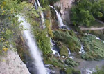
Scenes around Chilnualna Falls, southwest Yosemite National Park: pools and small cascades along Chilnualna Creek just above the cliff edge, the falls themselves seen from a small summit opposite, pools and narrow channels further upstream, and a larger pool at the base of granite cliffs. (1:53 min; 16.8 mb)
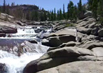
Seven scenes of the Tuolumne River, towards the west end of the Glen Aulin Trail from Tuolumne Meadows to the Glen Aulin campsite, Yosemite National Park: cascades leading to two large pools, the brink of Tuolumne Falls, cliffs around Tuolumne Falls, a pool beneath Tuolumne Falls, more cascades just downstream of Tuolumne Falls, and finally two views of White Cascade. (1:34 min; 18.2 mb)
This video shows the three main branches of the waterfall along East Rifle Creek, the main attraction of Rifle Falls State Park. The falls can be seen from below and above by a half mile loop trail, while another short path goes directly behind the largest of the cascades. (2:18 min; 18.5 mb)
Short video of Ice Lake and its grey-white inlet stream; reached by a 3 mile hike in the San Juan Mountains of southwest Colorado. (0:27 min; 13 mb)
Three units of Thousand Springs State Park in south Idaho: Niagara Springs, Earl M Hardy Box Canyon Springs and Malad Gorge. (0:36 min; 16 mb)
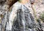
Cattail Falls, a secluded waterfall at the lower end of a deep, mostly inaccessible canyon on the west side of the Chisos Mountains in Big Bend National Park - reached by a 1.5 mile trail. (1:11 min)
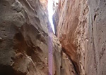
The upper end of the narrows of the Main Fork of Blue John Canyon - the view above and below a chokestone beneath the steep 200 foot long section that forms the start of the slot. (0:39 min; 5.4 mb)
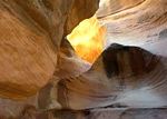
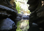
Passageways and pools in the Holeman Slot, a short, narrow ravine at the end of the Wilhite Trail in Canyonlands National Park, also reachable by the 4WD White Rim Road. (0:58 min; 18 mb)
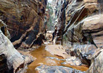
Waterfalls, pools and enclosed passageways in Sulphur Creek, which flows through a mile long narrows section, west of the visitor center in Capitol Reef National Park. The full hike is 5 miles, the rest of which is through a deep gorge that is still quite scenic. (1:05 min; 17 mb)
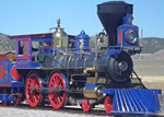
The replica Jupiter locomotive (Central Pacific no. 60), on the railroad tracks by the visitor center in Golden Spike National Historic Park. The train arrives from the nearby engine shed in reverse, then re-approaches from the west, matching the actual direction of the original during the Golden Spike ceremony on May 10th 1869. (0:47 min; 12 mb)
Five scenes in the lower (southern) end of the deep Navajo sandstone canyon of Death Hollow, an Escalante River tributary - in late summer, when the water levels are low. (0:50 min; 16 mb)
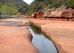
Permanent stream flowing through a pretty series of pools, cascades, chutes and narrow channels, enclosed by richly colored rocks. In a lightly visited recreation area north of St George. (0:49 min; 27 mb)
Pools, cascades and narrow water-carved channels through the Navajo sandstone, as Trachyte Creek flows along a shallow gorge a mile or two southeast of Highway 276. (1:32 min; 12.2 mb)
Pools, waterfalls and narrow channels in the middle of Water Canyon, on the south side of Canaan Mountain, ending with a view of the slickrock peaks around the upper end of the ravine. (1:05 min; 21 mb)

The narrows of Beartrap Canyon, an upper tributary of La Verkin Creek towards the north side of Zion National Park; reached by an 8.8 mile hike from the Lee Pass trailhead. The lower quarter of a mile forms a slot canyon, leading to a waterfall, above which the canyon is wider, though not accessible from below. (1:33 min)

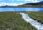
Four scenes along the shoreline of Jackson Lake, between Bearpaw Bay and Moran Bay, reached by a 6 mile hike starting at String Lake in Grand Teton National Park: a sandy beach, a shallow lagoon-like inlet, Moran Bay and Grassy Island. (0:57 min; 25 mb)
The Middle Fork of the Popo Agie River as it flows into a limestone cavern and disappears below ground into a network of narrow fissures (the sinks); it re-emerges 1/4 mile downstream in a shallow pool (the rise), then continues northeastwards towards Lander. The sinks, the rise, and 3.5 miles of the valley are contained within Sinks Canyon State Park. (0:52 min; 7 mb)
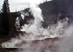
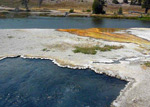
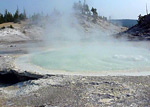
Thermal areas along the Solfatara Creek Trail: near the northern trailhead, the green-colored Lemonade Creek leads to Amphitheater Springs, a collection of fumaroles, small pubbling pools and sulphurous mudpots. Further south, Whiterock Springs has similar small-scale features, closer to the path. (1:35 min; 43 mb)
A few scenes along the loop path through Artists Paint Pots in Yellowstone National Park: two large mud pots, a wide view of the trail across the basin, the main geyser in the area (Blood Geyser), and steam plumes rising above other pools nearby. (1:27 min; 13 mb)
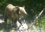
A medium sized grizzly bear walking from Eleanor Lake along a gully past the parking area for the Avalanche Peak Trail in Yellowstone National Park - on the East Entrance Road, half a mile west of Sylvian Pass. (0:20 min; 5 mb)
Scenes along the southernmost section of the Bechler River Trail in the Cascade Corner region of Yellowstone National Park: Cave Falls, the Falls River-Bechler River confluence, and Bechler Falls. (0:53 min; 24 mb)
Three scenes along the Blacktail Deer Creek Trail in Yellowstone National Park - a waterfall over the edge of a plateau formed by columnar lava, the trail bridge across the Yellowstone River, and a view downstream along the river from the bridge. (0:41 min; 10 mb)
Two waterfalls in Yellowstone's Cascade Corner, reached by an 8.5 mile hike mostly along the Boundary Creek Trail. Largest is Dunanda Falls, where Boundary Creek drops 150 feet over the edge of a plateau, while close by is the smaller but prettier Silver Scarf Falls, a cascade rather than a true waterfall, formed by a tributary creek flowing down a steeply sloping hillside. (1:02 min; 30 mb)
Three lesser-known features of Midway Geyser Basin in Yellowstone National Park: Fairy Falls, Spray Geyser and Imperial Geyser, reached by a 3 mile trail that starts alongside the Firehole River then turns west towards Fairy Creek. (0:41 min; 10 mb)
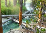
Four hot springs near the start of the Mallard Lake Trail in Yellowstone National Park: two right beside the Firehole River, south of the trail, and two in a wooded basin a little way north. (0:34 min; 15 mb)
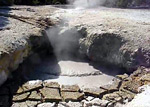
Hot springs, mud pots and warm pools of the Forest Springs Group, a backcountry thermal area in wooded land just south of the Grand Canyon of the Yellowstone - reached by the trail to Ribbon Lake. The only named feature is Surf Spring, a depressed, triangular vent filled by surging, steaming water. (2:18 min; 25 mb)
Thermal features of the Gibbon Hill and Geyser Creek groups, at the east side of Gibbon Geyser Basin, visited by a cross-country loop hike of 3.6 miles. Named features include Avalanche Geyser, Bat Pool, Big Bowl Geyser and Bulls Eye Spring. (1:29 min; 230 mb)
Selection of features in the top end of Heart Lake Geyer Basin: a mud pot and sulfurous vents near the path, a pair of large cloudy hot pools in the Upper Group, Deluge Geyser below Factory Hill, springs and vents in the Fissure Group either side of Witch Creek, and finally a few pools in the Middle Group, ending with a view of the trail as it continues southeast towards Heart Lake. (2:14 min; 18 mb)
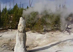
From the west side of Monument Geyser Basin in Yellowstone National Park, this video shows some of the hot springs, steam vents and geyser cones, of which the largest and most active is 8 foot tall Monument Geyser. The basin is reached by a steep, one mile trail starting at the north end of Gibbon Canyon, along the main road between Norris and Madison. (2:01 min; 17 mb)
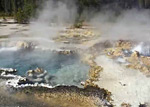
Four thermal features in and around the Morning Mist Springs in Yellowstone National Park's Lower Geyser Basin: Porcupine Hills Geyser, a mud pot, an elongated hot spring and a deep blue pool, these latter two being part of the nearby Quagmire Group. (0:33 min; 9 mb)
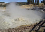
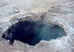
This 2 minute video shows six of the main thermal features in the Mud Volcano Group, in the center of Yellowstone National Park between Yellowstone Lake and the Grand Canyon: Turbulent Spring, Sulphur Cauldron, Dragons Mouth Spring, Mud Volcano, Churning Cauldron and Sour Lake. (2:11 min; 18 mb)
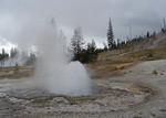
Rustic Geyser is the main attraction of Heart Lake Geyer Basin, and is situated right at the far (east) side of the active area - close to the lake and at the edge of the foothills of Mount Sheridan. This video starts with a general view of the geyser and the lake, then shows several other pools and springs in the area including Columbia Spring, and ends with an eruption of Rustic Geyser itself. (2:24 min; 19 mb)

Although the 2.2 mile, mostly level path to Sentinel Meadows in Yellowstone National Park's Lower Geyser Basin leads quite close to several large hot springs and geysers, rather more can be seen by careful walking off trail. Features include Red Terrace Spring (Queens Laundry), Steep Cone, Dumbbell Spring, The Bulgers and Mound Spring. (2:06 min; 18 mb)
Selection of pools and hot springs in Shoshone Geyser Basin, Yellowstone National Park - from the Minute Man, Orion, Island and Western groups, either side of Shoshone Creek. Features include Black Sulphur Spring, Soap Kettle, Minute Man Geyser, Impenetrable Spring, Union Geyser, Marble Cliff Spring, Boiling Cauldron and Great Crater. (3:58 min; 31 mb)
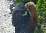
The Sulphur Springs, a backcountry thermal area in the Crater Hills, near Hayden Valley in Yellowstone National Park; bison on the mud flats to the south, then a selection of the pools and mud pots of the springs, including two of the named features, Turbid Blue Mud Spring and Crater Hills Geyser. This latter is the most active spring in the area, erupting constantly to heights of five feet or more. (2:08 min; 40 mb)
Thermal features of the Sylvan Springs Group, on the west side of Gibbon Geyser Basin in Yellowstone National Park, including Bridge Pool, Sylvan Spring, Evening Primrose Spring and Coffin Spring. (1:42 min; 46 mb)
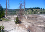
Small groups of mud pots and sulphurous pools along the southeast edge of Turbid Lake, reached by a 5 mile hike from the Pelican Valley trailhead, or a 3.5 mile hike from Lake Butte. Away from the springs, much of the lake is enclosed by mud flats and dead trees, and the surrounding hills are home to an active grizzly bear population. (0:41 min; 10 mb)
All Contents © Copyright The American Southwest | Comments and Questions | Contribute | Affiliate Marketing Disclosure | Site Map