Texas - Introduction
All of Texas belongs geographically to the Southwest of the USA but only part has the characteristic mountain and desert scenery. A little way west of San Antonio and San Angelo the land becomes empty and very sparsely settled, while from here eastwards the countryside is quite extensively farmed and inhabited - with woodland, meadows, meandering slow-moving rivers and some patches of swampland, a characteristic environment of states further east. The change in landscape occurs over quite a short range of 100 miles or so - this for example is the distance between the palm trees and swamps of Palmetto State Park, and the exposed granite and cacti of Enchanted Rock.
Texas finally ends near El Paso, where the Rio Grande having separated the US from Mexico for over 1,000 miles since the Gulf Coast turns due north and heads into New Mexico. The city is closer to Los Angeles than some places in east Texas and is distinctly Mexican in character.
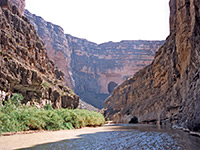
Towards the west edge of Texas, isolated mountains such as the Guadalupe, the Davis, the Chisos range in Big Bend National Park and several rugged ridges in Big Bend Ranch State Park rise above the desert, but most of the next 500 miles estwards is flat, featureless prairie. The Chisos and Guadalupe form the centerpiece of the only two national parks in Texas; neither receives many visitors compared with other Southwest parks, but Big Bend is becoming increasingly popular, and rightly so as it has a great variety of scenery and recreation opportunities.
Texas finally ends near El Paso, where the Rio Grande having separated the US from Mexico for over 1,000 miles since the Gulf Coast turns due north and heads into New Mexico. The city is closer to Los Angeles than some places in east Texas and is distinctly Mexican in character.
Towards the west edge of Texas, isolated mountains such as the Guadalupe, the Davis, the Chisos range in Big Bend National Park and several rugged ridges in Big Bend Ranch State Park rise above the desert, but most of the next 500 miles estwards is flat, featureless prairie. The Chisos and Guadalupe form the centerpiece of the only two national parks in Texas; neither receives many visitors compared with other Southwest parks, but Big Bend is becoming increasingly popular, and rightly so as it has a great variety of scenery and recreation opportunities.
The south and west of the state, about as far east as Del Rio, is part of the Chihuahuan Desert and has quite varied plant life but further north the land is more barren. In central Texas the plains eventually merge with the Edwards Plateau which rises gradually then breaks up into a series of steep-sided, wooded canyons and ridges, forming the Hill Country north and west of San Antonio. This area is famous for the displays of wildflowers during spring and has a number of interesting state parks, often based around rivers or lakes, including
Dinosaur Valley,
Lost Maples,
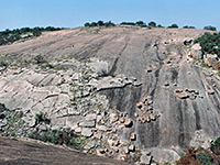
Enchanted Rock and
Pedernales Falls.
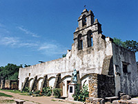
The center of San Antonio is distinctly European in atmosphere, with Spanish missions and the open-air cafes of the Paseo del Rio (The River Walk), and is also famous for The Alamo, symbol of Texan independence. South of the city, the Edwards Plateau is more gently undulating and slopes down gradually towards the Gulf Coast. The most notable natural feature in this area is Padre Island which has one of the largest stretches of undeveloped beach in the US, where deserted sand dunes stretch for 80 miles.
Far to the north, The Panhandle is a rather desolate region, part of the Great Plains of the American Midwest and is mostly quite flat, used for ranching and oil exploration, but with some scenic canyons such as those of the Red River and its tributaries southeast of Amarillo; Palo Duro Canyon and Caprock Canyons. It also has two lesser-known NPS units (Alibates Flint Quarries and Lake Meredith).
Texas is a vast state - over 800 miles in both length and breadth, and has many places worth visiting, although much driving is necessary between locations.
The center of San Antonio is distinctly European in atmosphere, with Spanish missions and the open-air cafes of the Paseo del Rio (The River Walk), and is also famous for The Alamo, symbol of Texan independence. South of the city, the Edwards Plateau is more gently undulating and slopes down gradually towards the Gulf Coast. The most notable natural feature in this area is Padre Island which has one of the largest stretches of undeveloped beach in the US, where deserted sand dunes stretch for 80 miles.
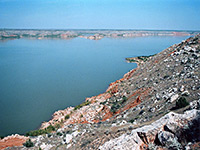
Far to the north, The Panhandle is a rather desolate region, part of the Great Plains of the American Midwest and is mostly quite flat, used for ranching and oil exploration, but with some scenic canyons such as those of the Red River and its tributaries southeast of Amarillo; Palo Duro Canyon and Caprock Canyons. It also has two lesser-known NPS units (Alibates Flint Quarries and Lake Meredith).
Texas is a vast state - over 800 miles in both length and breadth, and has many places worth visiting, although much driving is necessary between locations.
All Contents © Copyright The American Southwest | Comments and Questions | Contribute | Affiliate Marketing Disclosure | Site Map