Antelope Canyon
Beautiful but commercialized slot canyon, visited by hundreds of people on a typical day in summer. Two sections are open to visitors; the 600 foot long upper narrows, south of AZ 98, and the deeper lower narrows to the north
Length: 0.6 mile loop (upper canyon, to which visitors are driven in 4WD vehicles), 0.5 miles (lower canyon)
Difficulty: Easy. Ladders and railings are installed in the lower canyon
Management: Navajo Nation
Rocks: Navajo sandstone
Season: All year
Trailhead: Two parking areas south and north of AZ 98, 3 miles southeast of Page
Rating (1-5): ★★★★★
Difficulty: Easy. Ladders and railings are installed in the lower canyon
Management: Navajo Nation
Rocks: Navajo sandstone
Season: All year
Trailhead: Two parking areas south and north of AZ 98, 3 miles southeast of Page
Rating (1-5): ★★★★★

The world-famous slot of Antelope Canyon is located near Page on Navajo Nation land, just outside Glen Canyon National Recreation Area and close to Hwy 98 a few miles east of town, at milepost 299.
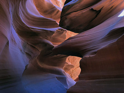
Antelope is the most visited slot canyon in the Southwest, partly because it is easily accessible and by far the most publicized, and also since it is extremely beautiful, with just the right combination of depth, width, length, rock color and ambient light; many other slot canyons are deeper, narrower or longer, and some have rock that is even more colorful and sculptured, but here conditions are ideal.
The canyon has two main sections, upper and lower, either side of the highway. All visitation is by guided tours, and it is recommended to book them in advance.
Tours are the only way to explore the canyon.
The seasonal stream of Antelope Creek flows into Lake Powell 3 miles east of Page in far north Arizona. Most of the watercourse is wide and sandy, but it forms two sections of accessible slot canyon near the lake (Upper and Lower Antelope Canyon), separated by several miles of flat desert terrain. Both may be approached from AZ 98; the upper canyon (also known as Corkscrew Canyon) is reached at the end of a very sandy 3 mile 4WD track south of the road beginning near milepost 299, and it is this part which is most often visited. Lower Antelope Canyon extends between AZ 98 and the lake, and is reached by a short track northwards leading to a parking area from where the escorted tours depart. This is slightly more demanding to visit, requiring climbing up and down several ladders.
To visit either part of Antelope Canyon is expensive. There is a fee of $8 for a standard permit required to enter Navajo territory, and an additional charge is due to the families who own the land around the canyons and regulate all access - the cheapest is currently (2024) around $100 for the shorter but more popular upper section and a little more for the longer lower canyon. Visits are only possible as part of organized tours, preferably booked in advance, though there may be availability on the day during less popular months. The price may be higher for peak time visits, departing 10 am to midday. The fees will doubtless increase as the Navajo continue to exploit the ever-growing popularity of the canyon.
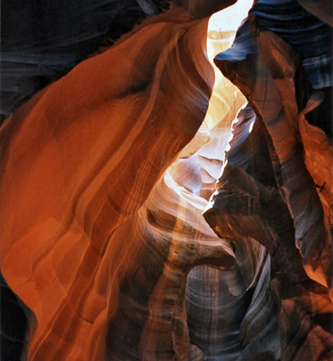
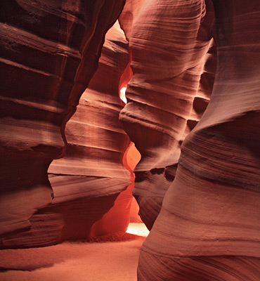
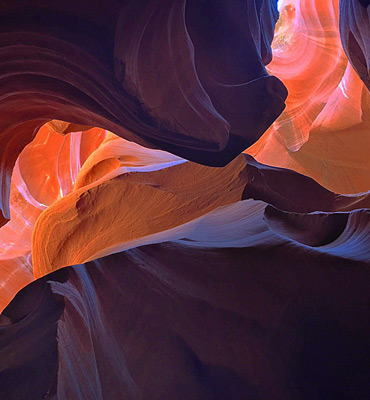
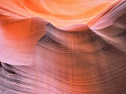
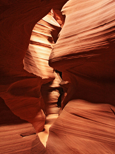
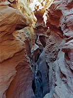
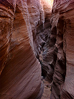
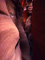
When approaching upper Antelope Canyon, there is no obvious clue as to its location. The trail seems to end at the base of a red sandstone plateau about 20 yards high, but the sight of an Indian jewelry stall soon indicates its position - the entrance is a narrow curved slit in the cliffs only a few feet wide. Once inside, the temperature drops as much as 20 degrees as the visitor enters one of the most beautiful of all natural formations. The sunlight filtering down the curved sandstone walls makes magical, constantly changing patterns and shadows in many subtle shades of color. Some sections of the canyon are wide and bright, while others are narrower and more cave-like, with no light reaching the sandy floor. After only 150 yards or so, the canyon becomes suddenly much shallower near the top of the plateau. It may take only 3 or 4 minutes to walk through, but the canyon is well worth the arduous trek or expensive journey required to get there. Pictures taken here adorn camera shops and photographic manuals throughout the world, and usually there will be many people trying to compose the perfect shot, perhaps grumbling when other people walk in front. At the end of the narrows, people no longer walk back the same way; instead they continue upstream a short distance, ascend the slope to the east, cross a sandy flat then return to the entrance via a flight of metal steps, to make a total loop of 0.6 miles.
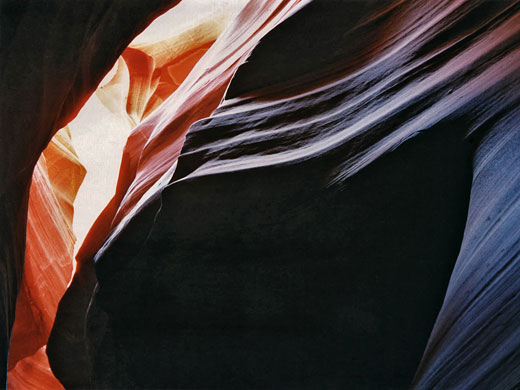
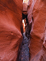
The lower canyon is longer and deeper than the upper section, but also slightly more challenging, requiring climbing down ladders in some places to descend several sheer drops. It was here that 11 people were drowned in a flash flood in August 1997, when water 50 feet deep from a thunderstorm 5 miles away swept through the canyon, eventually deepening it by 4 feet. Lower Antelope Canyon was closed for 9 months before reopening with improved safety features, and now all visitors must now be accompanied by a guide. Both parts of the canyon are still beautiful, but any sense of adventure or tranquility is long since gone - best to try one of the hundreds of other Southwest slot canyons for these qualities. The nearest non-Navajo alternatives, only requiring a $6 daily permit, are Buckskin Gulch and Wire Pass.
The short slot of Upper Antelope Canyon is six miles from Lake Powell but only about half way along the drainage, which to the south extends across empty desert land, initially as a sandy wash, then as a rocky gorge as the land gradually rises. Tributaries join from both sides, some also containing slot sections, while the upper end splits into two main forks, both deep and narrow. Several other segments of the drainage system have received semi-official names, and may be visited as part of specialized tours, charged in the range $80 to $250. Closest to Hwy 98 is Owl Canyon, which joins Antelope from the southwest, one mile from the road; this has a 900 foot-long slot near its lower end and much longer narrows 2.5 miles upstream, a section also known as Mountain Sheep Canyon. A little further, the uppermost stretch of the drainage is Ramshead Canyon, in which the walls partly overhang above the streambed. Another short slot known as Ligai Si Anii Canyon is also in this area, accessed from Copper Mine Road. The next major tributary south (0.7 miles before Upper Antelope) is Rattlesnake Canyon, the lower end of which forms a 500 foot slot, with two small arches. Wind Pebble Canyon is a longer tributary with several enclosed, photogenic sections, named for the stones embedded in the walls; it joins Antelope from the west, nearly 6 miles south of the highway. The two upper forks are Canyon X (east) and Cardiac Canyon (west) - both are cliff-lined for around one mile, containing slots alternating with more open passageways. The latter is rather more strenuous to explore. Two other, recently-introduced Antelope-area slots are Deer Canyon and Sand Dune Canyon.
Antelope is the most visited slot canyon in the Southwest, partly because it is easily accessible and by far the most publicized, and also since it is extremely beautiful, with just the right combination of depth, width, length, rock color and ambient light; many other slot canyons are deeper, narrower or longer, and some have rock that is even more colorful and sculptured, but here conditions are ideal.
The canyon has two main sections, upper and lower, either side of the highway. All visitation is by guided tours, and it is recommended to book them in advance.
Antelope Canyon FAQ
- Because of the easy access, along the main highway just outside Page, and because of the perfect combination of depth, width, rock color and orientation, giving ideal conditions for photography.
- Navajo sandstone, a Jurassic-era formation that occurs extensively across the Colorado Plateau, and is typically light red/orange in color.
- No, not since 1997; partly because of safety issues following a flash flood which killed 11 people, and partly because of the ever-increasing number of people, that now requires all visitation to be managed. Hence the canyon may only be seen as part of a guided tour.
- The upper canyon is shorter, narrower, with vertical walls and a flat floor (there is a flight of steps on the exit route, however) so is easier to explore, though also busier; nevertheless this is probably the best overall. The lower canyon is longer, deeper, with angled walls and several sheer drops requiring use of ladders, so is a little more testing to explore.
- Blue John Canyon, Happy Canyon, Moonshine Wash, Red Canyon (Peek-a-boo), Trachyte Point Canyon, Upper Chute Canyon and Water Holes Canyon, plus some others on the Navajo Reservation that are currently closed like Butterfly Canyon and East Fork Kaibito Creek.
- There are at least 15 different slots in the Antelope Canyon system, some longer, some shorter, and most of which are visitable on guided tours - other popular sections are Canyon X, Cardiac Canyon, Ligai Si Anii Canyon, Mountain Sheep Canyon, Owl Canyon, Ramshead Canyon, Rattlesnake Canyon and Wind Pebble Canyon.
- Yes, children of all ages should be able to navigate through both upper and lower Antelope.
- 100 minutes for the upper canyon (40 minutes driving there and back, around one hour in the narrows), and around 90 minutes for the lower canyon, all walking.
- The lower slot is right next to Hwy 98 (north side), and is entered directly from the parking lot, via a ladder, after a 0.2 mile walk. The upper slot is 3 miles south of the road, after a wide, sandy valley; visitors are transported here in Navajo vehicles.
- Also known as Horseshoe Bend Canyon, or just Secret Canyon, this is the Middle Fork of Upper Waterholes Canyon, so a completely different drainage, 6 miles west on the far side of US 89, and also only visitable on guided tours.

Tours of Antelope Canyon
Tours are the only way to explore the canyon.
Location
The seasonal stream of Antelope Creek flows into Lake Powell 3 miles east of Page in far north Arizona. Most of the watercourse is wide and sandy, but it forms two sections of accessible slot canyon near the lake (Upper and Lower Antelope Canyon), separated by several miles of flat desert terrain. Both may be approached from AZ 98; the upper canyon (also known as Corkscrew Canyon) is reached at the end of a very sandy 3 mile 4WD track south of the road beginning near milepost 299, and it is this part which is most often visited. Lower Antelope Canyon extends between AZ 98 and the lake, and is reached by a short track northwards leading to a parking area from where the escorted tours depart. This is slightly more demanding to visit, requiring climbing up and down several ladders.
Antelope Canyon Fees
To visit either part of Antelope Canyon is expensive. There is a fee of $8 for a standard permit required to enter Navajo territory, and an additional charge is due to the families who own the land around the canyons and regulate all access - the cheapest is currently (2024) around $100 for the shorter but more popular upper section and a little more for the longer lower canyon. Visits are only possible as part of organized tours, preferably booked in advance, though there may be availability on the day during less popular months. The price may be higher for peak time visits, departing 10 am to midday. The fees will doubtless increase as the Navajo continue to exploit the ever-growing popularity of the canyon.


Route Description
Upper Antelope Canyon
When approaching upper Antelope Canyon, there is no obvious clue as to its location. The trail seems to end at the base of a red sandstone plateau about 20 yards high, but the sight of an Indian jewelry stall soon indicates its position - the entrance is a narrow curved slit in the cliffs only a few feet wide. Once inside, the temperature drops as much as 20 degrees as the visitor enters one of the most beautiful of all natural formations. The sunlight filtering down the curved sandstone walls makes magical, constantly changing patterns and shadows in many subtle shades of color. Some sections of the canyon are wide and bright, while others are narrower and more cave-like, with no light reaching the sandy floor. After only 150 yards or so, the canyon becomes suddenly much shallower near the top of the plateau. It may take only 3 or 4 minutes to walk through, but the canyon is well worth the arduous trek or expensive journey required to get there. Pictures taken here adorn camera shops and photographic manuals throughout the world, and usually there will be many people trying to compose the perfect shot, perhaps grumbling when other people walk in front. At the end of the narrows, people no longer walk back the same way; instead they continue upstream a short distance, ascend the slope to the east, cross a sandy flat then return to the entrance via a flight of metal steps, to make a total loop of 0.6 miles.
Lower Antelope Canyon
The lower canyon is longer and deeper than the upper section, but also slightly more challenging, requiring climbing down ladders in some places to descend several sheer drops. It was here that 11 people were drowned in a flash flood in August 1997, when water 50 feet deep from a thunderstorm 5 miles away swept through the canyon, eventually deepening it by 4 feet. Lower Antelope Canyon was closed for 9 months before reopening with improved safety features, and now all visitors must now be accompanied by a guide. Both parts of the canyon are still beautiful, but any sense of adventure or tranquility is long since gone - best to try one of the hundreds of other Southwest slot canyons for these qualities. The nearest non-Navajo alternatives, only requiring a $6 daily permit, are Buckskin Gulch and Wire Pass.
Other Antelope Canyon Slots
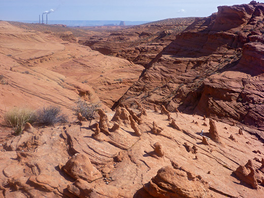
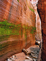
The short slot of Upper Antelope Canyon is six miles from Lake Powell but only about half way along the drainage, which to the south extends across empty desert land, initially as a sandy wash, then as a rocky gorge as the land gradually rises. Tributaries join from both sides, some also containing slot sections, while the upper end splits into two main forks, both deep and narrow. Several other segments of the drainage system have received semi-official names, and may be visited as part of specialized tours, charged in the range $80 to $250. Closest to Hwy 98 is Owl Canyon, which joins Antelope from the southwest, one mile from the road; this has a 900 foot-long slot near its lower end and much longer narrows 2.5 miles upstream, a section also known as Mountain Sheep Canyon. A little further, the uppermost stretch of the drainage is Ramshead Canyon, in which the walls partly overhang above the streambed. Another short slot known as Ligai Si Anii Canyon is also in this area, accessed from Copper Mine Road. The next major tributary south (0.7 miles before Upper Antelope) is Rattlesnake Canyon, the lower end of which forms a 500 foot slot, with two small arches. Wind Pebble Canyon is a longer tributary with several enclosed, photogenic sections, named for the stones embedded in the walls; it joins Antelope from the west, nearly 6 miles south of the highway. The two upper forks are Canyon X (east) and Cardiac Canyon (west) - both are cliff-lined for around one mile, containing slots alternating with more open passageways. The latter is rather more strenuous to explore. Two other, recently-introduced Antelope-area slots are Deer Canyon and Sand Dune Canyon.
Map of Slot Canyons of Antelope Creek
Nearby Slot Canyons
Antelope is one of the top 25 slot canyons
Antelope Canyon - Similar Hikes
All Contents © Copyright The American Southwest | Comments and Questions | Contribute | Affiliate Marketing Disclosure | Site Map