Upper Middle Fork
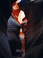
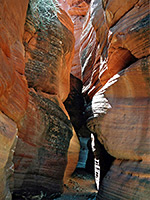
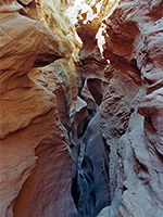
The middle fork of upper Water Holes Canyon forms a short, deep slot that rivals Antelope Canyon for nicely lit, swirling formations, while a little way further upstream are the darkest, narrowest passages of the whole system, though rather more effort is necessary to reach them
Length: 4.5 miles
Trailhead: Parking area on the east side of US 89
Rating (1-5): ★★★★★
Trailhead: Parking area on the east side of US 89
Rating (1-5): ★★★★★

Like all the narrow upper tributaries of Water Holes Canyon, the middle fork is much closer to IR 20 (Copper Mine Road, running due south from Page) than US 89 but access from here involves parking at roadside then crossing private property, both of which are not permitted, according to the staff at the Navajo parks and recreation office at nearby Leche. Instead, the canyon can, in theory, only be reached from US 89, by travelling east, up or alongside the main streamway for about 3 miles, a walk which is mostly over soft sand so can be quite tiring. However, as of 2010 this too is not allowed, and the narrows may only be visited as part of a guided tour.
The deepest section of narrows used to be known informally as Secret Canyon, and is now Horseshoe Bend Canyon, to take advantage of the greatly increased popularity of the nearby Horseshoe Bend Overlook
See the narrows on a Navajo guided tour - the only way to visit the canyon.
Topographic map of Water Holes Canyon.
14 views of the middle fork of upper Water Holes Canyon.
The best route is along the north rim until just after the powerlines that mark the end of the confined middle section of the canyon, then down to the wash, taking the left (main) fork once the narrows open out, walking 1.5 miles to the next fork, turning left here and following the wash around a big bend where it becomes very wide, as cliffs start to rise at either side and a second set of powerlines comes into view ahead. At the next junction, the main branch continues east towards the powerlines, while the right branch heads south, and this is the section that has the best narrows. All the streambeds and surrounding sandy hills are crossed by ATV tracks so instead of the long hike, driving all the way from US 89 might be possible.
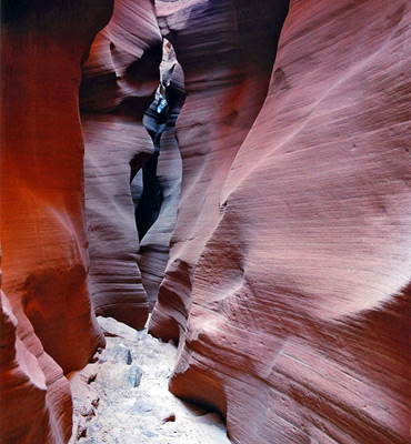
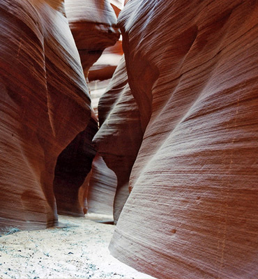
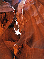
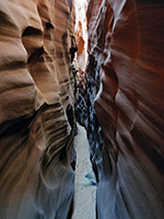
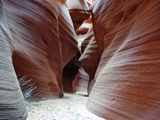
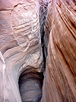
The streamway narrows after a while, bends to the left then finally turns into a slot and all the tedious walking becomes worthwhile. It starts with a straight sunlit section between vertical, angular rock walls then enters a series of dark passageways, very similar to upper Antelope Canyon, as curving, reddish rocks overhang above making some parts very dark, and others nicely illuminated - an ever changing mixture of patches of direct light, reflections and shadows. The canyon has a sandy floor, mostly level, with no obstructions, but doesn't last very long, opening out quite abruptly into another sandy wash.
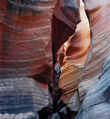
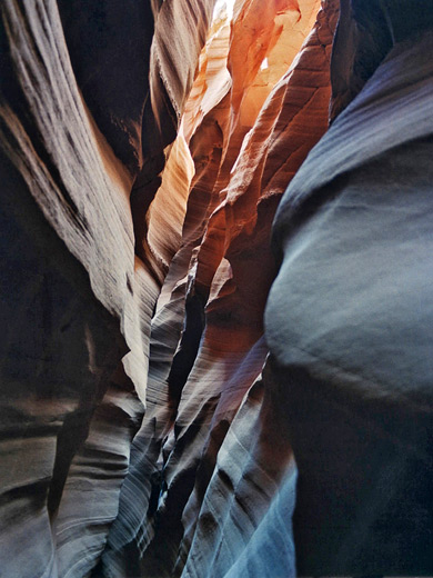
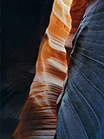
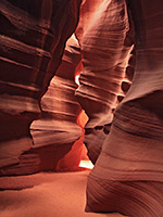
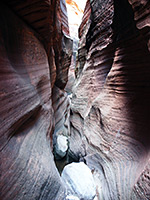
But this is not the end of the slot canyon, as in less than half a mile the wash constricts again beneath a 3 meter dryfall. This can be passed by climbing a small hill on the west side to reveal more shallow narrows; a small branch to the left soon ends at a higher fall but the main branch to the right continues a long way. This has more deep narrows, very tight - only 8 inches across in places, dark and very impressive, again with a flat sandy floor and many curves, fins, protruding rocks and beautifully colored red orange walls. Eventually progress is interrupted by an upwards jump of about 2 meters, which is difficult to climb up as the canyon is so narrow. The drainage can be followed further upstream from above by back-tracking quite a way then climbing up the cliffs, and seems to continue for some distance. The head of this branch of the canyon is just west of a small elevation marked 5343T on the topographic map. Overall, the middle fork of upper Water Holes is an excellent canyon - one of the best in the area.
The deepest section of narrows used to be known informally as Secret Canyon, and is now Horseshoe Bend Canyon, to take advantage of the greatly increased popularity of the nearby Horseshoe Bend Overlook
Tours of Secret Canyon
See the narrows on a Navajo guided tour - the only way to visit the canyon.
Map
Topographic map of Water Holes Canyon.
Photographs
14 views of the middle fork of upper Water Holes Canyon.
Route Description
The best route is along the north rim until just after the powerlines that mark the end of the confined middle section of the canyon, then down to the wash, taking the left (main) fork once the narrows open out, walking 1.5 miles to the next fork, turning left here and following the wash around a big bend where it becomes very wide, as cliffs start to rise at either side and a second set of powerlines comes into view ahead. At the next junction, the main branch continues east towards the powerlines, while the right branch heads south, and this is the section that has the best narrows. All the streambeds and surrounding sandy hills are crossed by ATV tracks so instead of the long hike, driving all the way from US 89 might be possible.
The Main Slot
The streamway narrows after a while, bends to the left then finally turns into a slot and all the tedious walking becomes worthwhile. It starts with a straight sunlit section between vertical, angular rock walls then enters a series of dark passageways, very similar to upper Antelope Canyon, as curving, reddish rocks overhang above making some parts very dark, and others nicely illuminated - an ever changing mixture of patches of direct light, reflections and shadows. The canyon has a sandy floor, mostly level, with no obstructions, but doesn't last very long, opening out quite abruptly into another sandy wash.
The Upper Narrows
But this is not the end of the slot canyon, as in less than half a mile the wash constricts again beneath a 3 meter dryfall. This can be passed by climbing a small hill on the west side to reveal more shallow narrows; a small branch to the left soon ends at a higher fall but the main branch to the right continues a long way. This has more deep narrows, very tight - only 8 inches across in places, dark and very impressive, again with a flat sandy floor and many curves, fins, protruding rocks and beautifully colored red orange walls. Eventually progress is interrupted by an upwards jump of about 2 meters, which is difficult to climb up as the canyon is so narrow. The drainage can be followed further upstream from above by back-tracking quite a way then climbing up the cliffs, and seems to continue for some distance. The head of this branch of the canyon is just west of a small elevation marked 5343T on the topographic map. Overall, the middle fork of upper Water Holes is an excellent canyon - one of the best in the area.
Middle Fork of Water Holes Canyon - Similar Hikes
All Contents © Copyright The American Southwest | Comments and Questions | Contribute | Affiliate Marketing Disclosure | Site Map