Sites in Arizona
NPS - Landscapes
Canyon de Chelly
Chiricahua
Grand Canyon
Lake Mead
Organ Pipe
Petrified Forest
Saguaro
Sunset Crater
NPS - Historic Sites
Casa Grande Ruins
Coronado
Montezuma Castle
Pipe Spring
Tonto
Tumacacori
Tuzigoot
Walnut Canyon
Wupatki
Other Places
Apache Trail
Ironwood Forest NM
Meteor Crater
Route 66
Sedona
Sonoran Desert NM
Tonto NF
Vermilion Cliffs NM
Arizona Site Map
Site Search

|
|
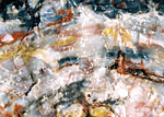
On first impression, the Petrified Forest may not sound very appealing as it comprises stone log fragments scattered over a rather remote and otherwise featureless section of Arizona desert. Apparently it comes as a disappointment to some who expect the trees to be still standing in thick rocky groves instead of lying flat in sections as they are. But the petrified logs are extremely beautiful with most unexpectedly bright colors, and the park is adjacent to the scenic Painted Desert so it is well worth a visit especially as it is quite easily reached, being close to the main east-west route interstate 40.

The North - the Painted Desert: A 27 mile road runs through the Petrified Forest National Park, from exit 311 of I-40 south to US 180. The surroundings are mostly empty grasslands, and the closest town is Holbrook, 25 miles to the west. The visitor center is at the north end and there is a small museum at the south entrance. In the north, the first few miles of this road winds along the rim of a mesa overlooking the Painted Desert, and has 8 viewpoints of the rolling multicolored landscape, with one short trail along the cliff edge. The patterns visible in the eroded soft sedimentary rocks are due mainly to hematite (red), limonite (yellow) and gypsum (white), and the colors are especially striking at sunset. The park boundaries have been extended twice, in 1932 and 1970, to include a large area of the desert to the north but there are no regognized trails into this region although off-trail hiking and back-country camping are allowed. Several other sections of northeast Arizona are also known as the Painted Desert, including a large region around US 89 north of Flagstaff, close to the Colorado River.
The South - Petrified Wood: After the final overlook of the Painted Desert (Lacey Point), the road turns due south, crosses the interstate and a branch of the Atchinson, Topeka & Santa Fe railway, then passes through the petrified region. The first feature of interest is an Indian ruin - Puerco Pueblo - which is toured by a 0.3 mile loop trail, and is just one of the over 500 archeological sites within the park. Another is found 1.5 miles south at Newspaper Rock, a sandstone outcrop bearing hundreds of petroglyphs dating from around 1000-1300 AD. There are more petroglyphs along a short side track close to the south edge of the park (starting from Giant Logs museum), but the main viewpoints along the southern section of the park are of the petrified wood. Unusually for a national park, there are no extended trails in the area, only short paths close to the road. Off trail hiking is permitted only in the Painted Desert wilderness north of I-70.
|
|
Petrified Forest - More Information
Viewpoints - trails and overlooks along the south section of the park road
Conservation - measures taken to prevent thefts of rock samples
Geology - how the stone logs were formed
Map - map of the national park
Petrified Forest - Photography
Photographs; 19 views of the park
QTVR Panorama - The Tepees; small | large
|
Camping: Partly to protect the natural resources, there are no campsites in Petrified Forest National Park; the only camping allowed within the park is for backpackers in the Painted Desert wilderness area, north of the interstate. The surrounding land also has patches of petrified wood, and is privately owned and fenced off, so there is no place for free camping nearby. Closest options for this seem to be one of several junctions of I-40, either side of the park turn-off - exits 303, 320 and 325, each of which has short tracks leading into the desert where overnight parking/camping should be possible.
Hotels: For hotels, nearby Holbrook has about 12 choices - one is the Holiday Inn Express Holbrook at 1308 E. Navajo Blvd, just north of I-40 (exit 286) and 25 miles from the northern entrance to the national park. The hotel has 59 rooms, was renovated as recently as 2006, and is within walking distance of the center of Holbrook, which is a small town but with a fair selection of restaurants and shops.
Check rates/make reservation at the Holiday Inn Express Holbrook
More Holbrook Hotels
 |
|
|
Selected Petrified Forest books, from amazon.com
|
|
Petrified Forest - Similar Places
Bisti Badlands, New Mexico - distant landscape of colorful mounds and fossils
Buckskin Gulch, Utah - here, petrified wood is scattered around the start of the Wire Pass side canyon | |
|