Lower White Canyon
The lowest part of the long drainage of White Canyon, from the Hwy 95 road bridge downstream to the end of the narrows; slots, dark passages, extravagantly eroded potholes, huge boulders, fluted falls and other formations
Length: 2.8 miles, to the canyon below the bridges
Difficulty: Moderate - wading pools, climbing over boulders
Management: NPS - part of Glen Canyon NRA
Rocks: Cedar Mesa sandstone
Season: All year, though not after heavy rainfall
Trailhead: Dirt track beside the lower canyon, or a little way back along the track
Rating (1-5): ★★★★★
Difficulty: Moderate - wading pools, climbing over boulders
Management: NPS - part of Glen Canyon NRA
Rocks: Cedar Mesa sandstone
Season: All year, though not after heavy rainfall
Trailhead: Dirt track beside the lower canyon, or a little way back along the track
Rating (1-5): ★★★★★

White Canyon, a tributary of the Colorado River at the upper end of Lake Powell, is a large drainage, winding for over 40 miles across a plateau of Cedar Mesa sandstone, and is most famous for the Black Hole, a narrow, enclosed, permanently flooded, 500 foot section where swimming is required to pass through. Much of the canyon though is relatively open, often quite shallow if not always easy to enter from the rim, but one other good section with easy access, suitable for a half day hike, is the lowest 2.5 miles, downstream from the vicinity of the Hwy 95 bridge, where the canyon is 250 feet deep.
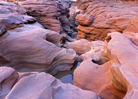
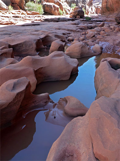
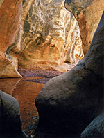
Within this stretch are flooded slots, dark passages, extravagantly eroded potholes, huge boulders, fluted falls and other formations, often quite colorful. Wading is necessary in many places, usually not swimming, plus clambering round, over or even under some of the boulders.
Access to a shallow part of the drainage, downstream of this enclosed stretch of the canyon, is via an unpaved track off the main road, little used though fine for most vehicles, and also passing good places for primitive camping.
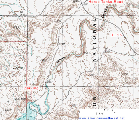
The unsigned track to the lower end of the White Canyon narrows forks southwest off UT 95 half a mile from the highway bridge, opposite the wider Horse Tanks Road (FR208A) which leads to various remote locations including Fortknocker Canyon and Dark Canyon. The track crosses a few minor washes where the surface is bare rock but mostly follows smooth, sandy ground at the edge of the reddish Moenkopi Formation, which overlies the Cedar Mesa sandstone around the canyon to the east. The track meets the streambed after 2.1 miles, crosses it, and, now rather rougher, follows the opposite side northeastwards, back to the highway.
The hike could begin from the crossing point, though upstream the drainage curves through a broad, U-shaped bend, staying shallow for a while, so a slightly shorter option is to park a quarter of a mile or so back and walk southeast over a wide sandy bench then look for a way down the low cliffs which line the west side of the drainage. This part of the streambed is flooded at the highest water levels of Lake Powell though has not been so for many years.
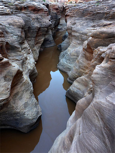
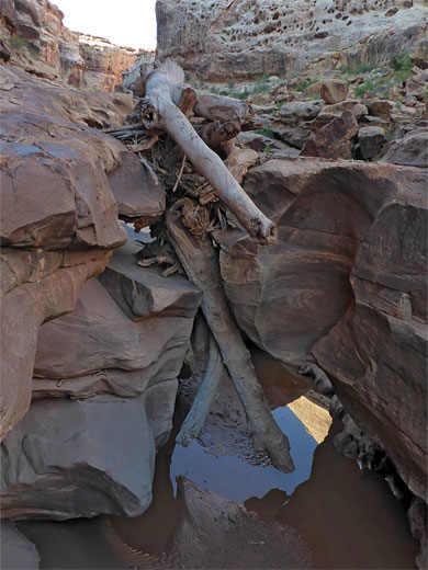
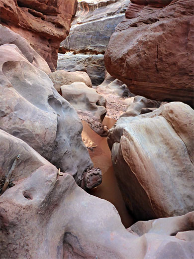
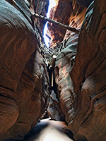
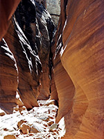
Around the wide bend, the canyon is up to 300 feet across and only about 40 feet deep, with a flat sandy floor and bushy sandbanks at one or both sides, but it soon narrows as it heads north, deepening slowly as the land at either side gradually slopes up. A straight section leads to the first few places where pools are likely, requiring wading, and then a shallow slot, passed by walking along a bench to the right. The canyon bends to the right then back left, and enters a more generally narrow stretch including a deeper slot, permanently flooded, with a pinch point above the far end, possibly holding a big log jam. These narrows are also bypassed, if desired, by a bench on the right side, perhaps crossing to the left at the logjam, just beyond which is a sequence of big boulders and then a brief, pretty section of fluted, water-carved rock.
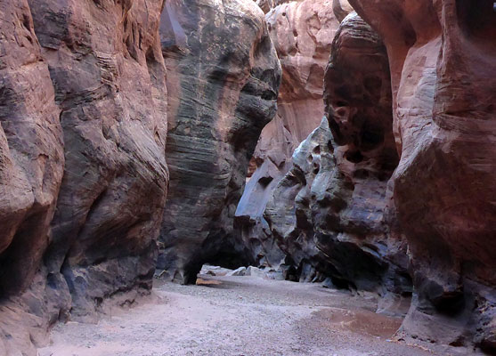
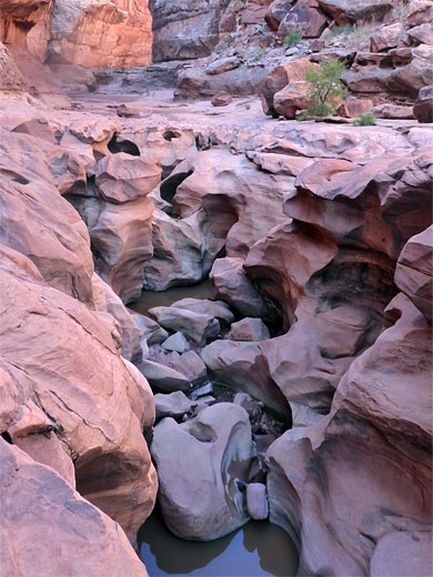
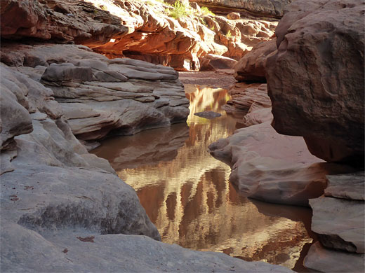
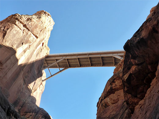
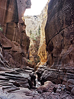
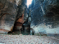
The gorge opens out somewhat, curves round a bend and enters a long, straight containing smaller boulders and shallow pools. Round the next bend is another fluted floor and some even bigger boulders, piled on top of each other, passed by climbing above or scrambling/wading underneath. The next section is the deepest, and narrowest, including a flooded inner slot with bench above, on the south side, and a rather gloomy, vertical-walled passage also containing muddy pools, and then some more big boulders as the highway bridge approaches, 250 feet above. Past the bridge the canyon stays quite narrow around stream level but is wider higher up, above a bench; it heads north for a while before curving round the next bend, out of sight. The Black Hole is 4 miles upstream, after many more bends and shallow narrows.
Within this stretch are flooded slots, dark passages, extravagantly eroded potholes, huge boulders, fluted falls and other formations, often quite colorful. Wading is necessary in many places, usually not swimming, plus clambering round, over or even under some of the boulders.
Access to a shallow part of the drainage, downstream of this enclosed stretch of the canyon, is via an unpaved track off the main road, little used though fine for most vehicles, and also passing good places for primitive camping.

Topographic Map of Lower White Canyon
White Canyon Location
The unsigned track to the lower end of the White Canyon narrows forks southwest off UT 95 half a mile from the highway bridge, opposite the wider Horse Tanks Road (FR208A) which leads to various remote locations including Fortknocker Canyon and Dark Canyon. The track crosses a few minor washes where the surface is bare rock but mostly follows smooth, sandy ground at the edge of the reddish Moenkopi Formation, which overlies the Cedar Mesa sandstone around the canyon to the east. The track meets the streambed after 2.1 miles, crosses it, and, now rather rougher, follows the opposite side northeastwards, back to the highway.
Start Point
The hike could begin from the crossing point, though upstream the drainage curves through a broad, U-shaped bend, staying shallow for a while, so a slightly shorter option is to park a quarter of a mile or so back and walk southeast over a wide sandy bench then look for a way down the low cliffs which line the west side of the drainage. This part of the streambed is flooded at the highest water levels of Lake Powell though has not been so for many years.
The Canyon
Around the wide bend, the canyon is up to 300 feet across and only about 40 feet deep, with a flat sandy floor and bushy sandbanks at one or both sides, but it soon narrows as it heads north, deepening slowly as the land at either side gradually slopes up. A straight section leads to the first few places where pools are likely, requiring wading, and then a shallow slot, passed by walking along a bench to the right. The canyon bends to the right then back left, and enters a more generally narrow stretch including a deeper slot, permanently flooded, with a pinch point above the far end, possibly holding a big log jam. These narrows are also bypassed, if desired, by a bench on the right side, perhaps crossing to the left at the logjam, just beyond which is a sequence of big boulders and then a brief, pretty section of fluted, water-carved rock.

Deeper Passageways
The gorge opens out somewhat, curves round a bend and enters a long, straight containing smaller boulders and shallow pools. Round the next bend is another fluted floor and some even bigger boulders, piled on top of each other, passed by climbing above or scrambling/wading underneath. The next section is the deepest, and narrowest, including a flooded inner slot with bench above, on the south side, and a rather gloomy, vertical-walled passage also containing muddy pools, and then some more big boulders as the highway bridge approaches, 250 feet above. Past the bridge the canyon stays quite narrow around stream level but is wider higher up, above a bench; it heads north for a while before curving round the next bend, out of sight. The Black Hole is 4 miles upstream, after many more bends and shallow narrows.
Nearby Slot Canyons
Bullfrog Bay Canyon
Butler Canyon
Cheesebox Canyon
Death Canyon
Fortknocker Canyon
Fry Canyon
Gravel Canyon
Long Canyon
Maidenwater Canyon
Maidenwater Canyon, North
North Trachyte Point Canyon
North Wash
Poison Spring Canyon
Rock Canyon
Smith Fork
Swett Creek
Trachyte Creek
Trachyte Point Canyon
Trail Canyon
White Canyon
Lower White Canyon - Similar Hikes
All Contents © Copyright The American Southwest | Comments and Questions | Contribute | Affiliate Marketing Disclosure | Site Map