Highlights:
Badlands, petrified wood, hoodoos and a huge range of other eroded formations near Ah-Shi-Sle-Pah Wash in the San Juan Basin, including the 'Alien Throne'. All rocks are from the Fruitland Formation, a mix of shale, sandstone, mudstone, siltstone, coal and clinker. Reached by a hike of 1.2 miles, but much time could be spent exploring
Nearby town:
Bloomfield, 55 miles
Management:
BLM, Navajo Nation
Location:
Along a short track off road 7870, 17 miles from Hwy 371
Seasons:
All year
Rating (1-5):
★★★★★

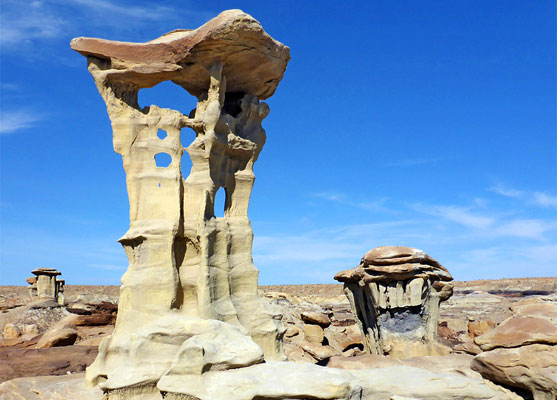
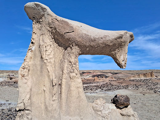
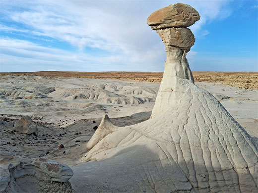
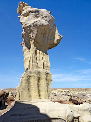
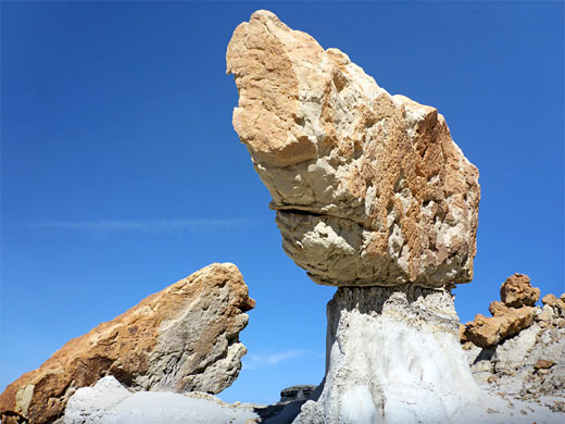
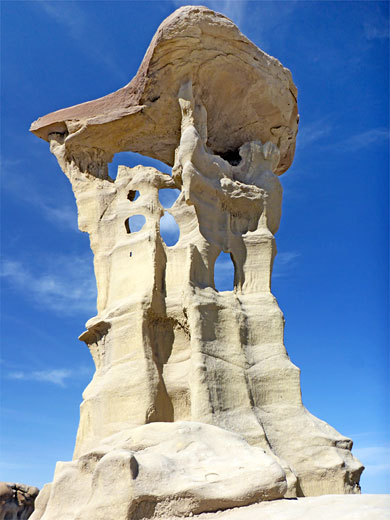
Valley of Dreams has in recent years become one of the more well-known locations in the San Juan Basin badlands of northwest New Mexico; a relatively small area of hoodoos and fantastically eroded rocks along the shallow valley of Ah-Shi-Sle-Pah Wash, on land of the Navajo Reservation. All rocks here are from the Fruitland Formation, a mix of shale, sandstone, siltstone and mudstone, generally white to brown in color, plus some black coal seams, red clinker and scattered pieces of reddish-brown petrified wood. The most famous feature is the Alien Throne, a sandstone boulder atop a tall, delicate pedestal - both it and the valley were so-named, unofficially, around 2010 or earlier by some of the first hikers and photographers to properly explore this region.
The valley is less than 2 miles from the western boundary of the Ah-Shi-Sle-Pa Wilderness, which has a broadly similar landscape though differing bedrock, the Kirtland Formation rather than the Fruitland. The place is quite easily reached, by a hike of 1.2 miles over level ground, starting from a trailhead which is at least 15 miles from a paved road though the drive is along good quality dirt tracks, generally suitable for all vehicles during dry conditions. The main area of formations is just a quarter of a mile across but there is enough to see here to spend a whole day.
The valley is less than 2 miles from the western boundary of the Ah-Shi-Sle-Pa Wilderness, which has a broadly similar landscape though differing bedrock, the Kirtland Formation rather than the Fruitland. The place is quite easily reached, by a hike of 1.2 miles over level ground, starting from a trailhead which is at least 15 miles from a paved road though the drive is along good quality dirt tracks, generally suitable for all vehicles during dry conditions. The main area of formations is just a quarter of a mile across but there is enough to see here to spend a whole day.
Valley of Dreams Table of Contents
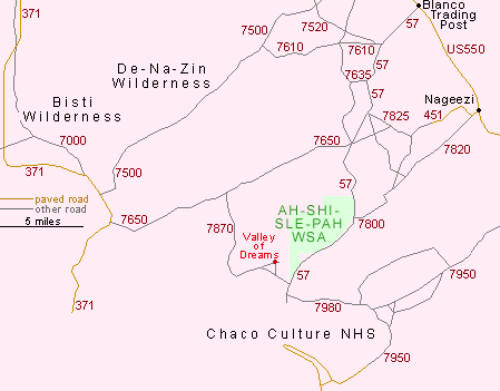
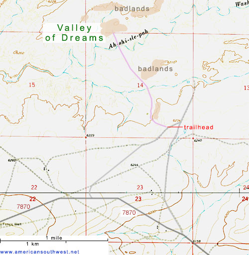
Location
Map of badlands in the San Juan Basin.
Photographs
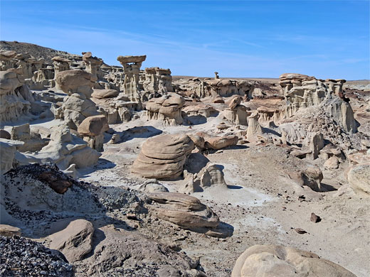
65 views of the Valley of Dreams.
Valley of Dreams Video
Access to the Valley of Dreams
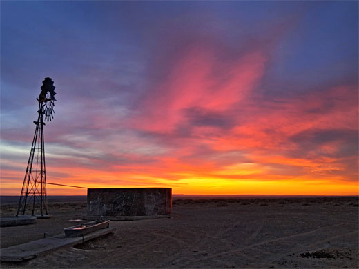
The Valley of Dreams can be reached from three directions, west, east and south. The western route starts from Hwy 371; east along road 7650 for 8 miles then 7 miles south along 7870 and finally northeast for 1.2 miles along one of two lesser tracks to the trailhead, a flat area on the rim of a low mesa. The other track, similar in length, leaves 7870 1.3 miles further. The eastern access is via Hwy 57, the same route to the Ah-Shi-Sle-Pah Wilderness, continuing a little way past here to the 7870 junction, and then to the two lesser tracks, while the southern route is off road 7950, the (relatively) busy though still unpaved road to Chaco Culture NHS - 2.8 miles north of the NHS, a narrower road (7980) forks off to the northwest, following Escavada Wash and in 6.3 miles meeting Hwy 57, less than a mile south of the 7870 junction. All the major tracks are generally in good condition, wide with a smooth surface, crossing empty, treeless landscapes with just a few scattered dwellings, some ruinous. There are plenty of potential camp places hereabouts, such as next to a watertower along road 7870, on public land 2 miles west of the trailhead.
Driving Routes to the Valley of Dreams
Geology of the Valley of Dreams
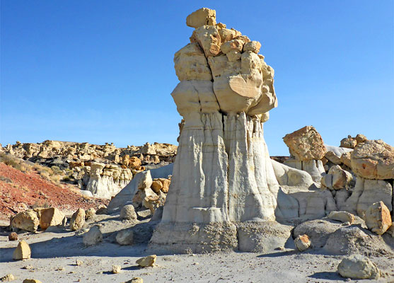
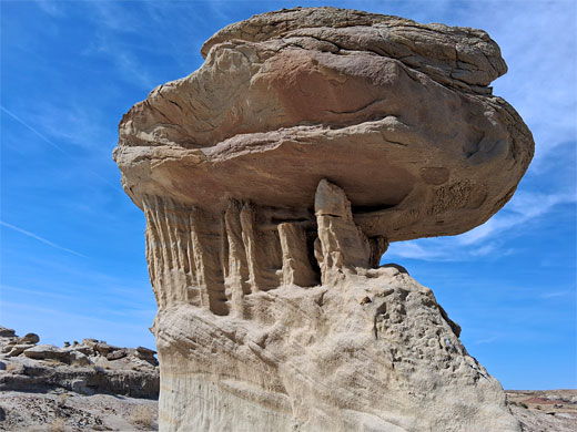
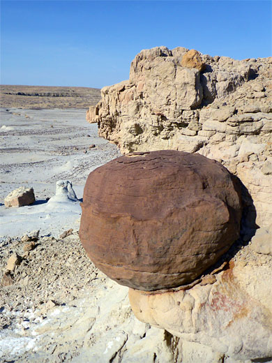
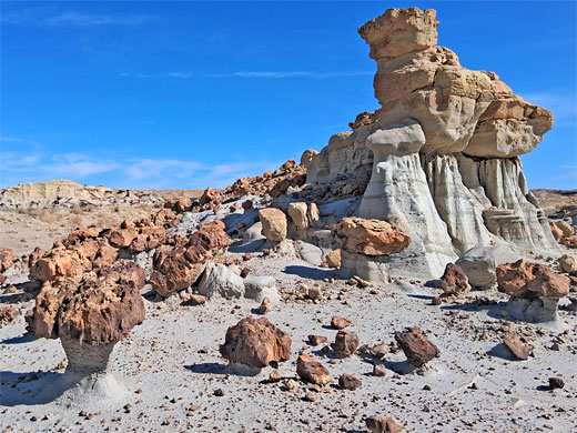
The Fruitland Formation, which makes up all of the exposed rocks in the Valley of Dreams, comprises a complex sequence of generally thin layers of coal, carboniferous shale, mudstone, siltstone and sandstone. The coal is in some places partly overlain by red clinker, this the result of partial combustion during ancient underground fires. The sandstone is light in color, white to yellow grey, the mudstone and siltstone are generally darker, brown to dark yellow, and the shale is darker grey. The sandstone contains occasional spherical concretions of dark brown ironstone, some over 3 feet in diameter.
Hiking Route
From the trailhead, a path descends the slope to the north and crosses the flats below, passing some minor badlands to the east, then over a dry streambed, a tributary of Ah-Shi-Sle-Pah Wash. The path may not always be evident, and in some places there are several parallel routes, but walking is always easy, heading for the more prominent line of badlands to the north. Soon after the tributary is an intermediate group of hoodoos, also to the east, and well worth exploring. Closest to the path are a few more isolated but quite large formations, including the 'Three Wise Men' while to the east the exposed rocks are more extensive, and the hoodoos closer together, separated by little ravines. Jagged reddish boulders are scattered over some of the slopes. The walking route continues northwards, across the main fork of the wash and onto the largest area of formations. Some people drive all the way here, cross-country, while others take vehicles down the tributary drainage, but this is not encouraged; all people should park at the trailhead.
The Formations
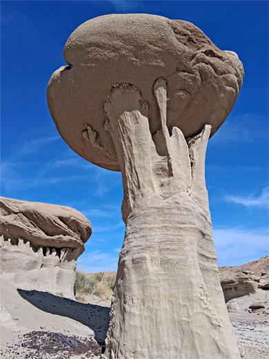
The main section of the Valley of Dreams extends along the north and south sides of a low, narrow ridge, orientated west to east. The strata include two layers of coal with quite extensive red clinker, and many lighter-colored bands. Again towards the west the formations are more spread out, the clinker more evident, and to the east are denser outcrops, the rocks mostly grey, brown or white. Petrified wood is found in just a few places. The single best area is on the north side of the ridge. including the famous Alien Throne, not necessarily easy to find but quite obvious when in the vicinity. There is a similar, smaller feature on the south side, the Mini Alien Throne. The whole place has relatively low relief; only 40 feet from the top of the ridge to the flat plains below.
Valley of Dreams - Nearby Places
- Ah-Shi-Sle-Pah Wilderness (5 miles) - remote region of hoodoos, badlands and other eroded rocks
- Chaco Culture National Historical Park (13 miles) - ruins of the largest and most advanced ancient villages in the Southwest
Valley of Dreams - Similar Places
- Bisti Wilderness, New Mexico - hoodoos, badlands and other eroded rocks
- Burnham Badlands, New Mexico - amazing badlands of the Kirtland Formation
All Contents © Copyright The American Southwest | Comments and Questions | Contribute | Affiliate Marketing Disclosure | Site Map