Johnson Lake and South Fork Baker Creek Trails, Great Basin National Park
Nevada > Great Basin National Park > Johnson Lake and South Fork Baker Creek Trails
Johnson Lake and South Fork Baker Creek Trails
Old mine relics and a high elevation lake, in a basin below Pyramid Peak, reached by a long trail up a sheltered valley, over a saddle and across wooded slopes. Continues to a pass, then descends towards Baker Lake
Length: 5.5 miles to Johnson Lake, 6 miles to the pass
Elevation change: 2,760 feet, 3,300 feet
Difficulty: Moderate to strenuous
Type: One-way, or part of a 12.5 mile loop back via Baker Creek
Usage: Low
Season: Summer and early fall
Trailhead: End of the unpaved Baker Creek Road
Rating (1-5): ★★★★★
Elevation change: 2,760 feet, 3,300 feet
Difficulty: Moderate to strenuous
Type: One-way, or part of a 12.5 mile loop back via Baker Creek
Usage: Low
Season: Summer and early fall
Trailhead: End of the unpaved Baker Creek Road
Rating (1-5): ★★★★★

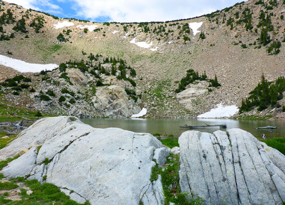
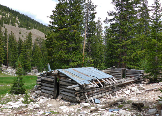
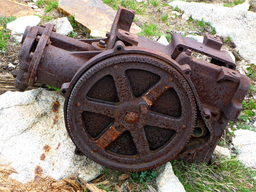
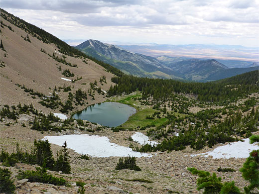
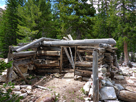
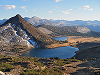
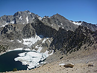
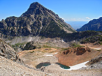
Spring-fed Johnson Lake, one of the six small lakes in Great Basin National Park, sits in a glacial cirque just east of the mountain crest, ringed by steep scree slopes on three sides, a little way above the timberline at an elevation of 10,750 feet. Early in the 20th century the hillsides above were mined in two locations for tungsten, an operation that continued until 1935 when many of the mine buildings were damaged by an avalanche, resulting in closure, though various artifacts remain including cabins, a mill, an aerial tramway and assorted iron machinery.
Johnson Lake and Johnson Mine may be reached by three routes - the shortest and steepest trail starts from the end of Snake Creek Road, climbing 2,400 feet over 3.7 miles, while the longest (5.5 miles) and most varied, described below, begins from the large parking area at the end of Baker Creek Road, first following the South Fork of Baker Creek through woodland and meadows then climbing over a saddle on the ridge that divides the drainage from Snake Creek to the south, traversing more wooded slopes and climbing steadily to the lake. The third option (4.9 miles) starts at the same location but follows the shorter Timber Creek drainage before ascending to a junction just below the saddle. For the latter two routes, a loop can be made, another 7 miles, by crossing the ridge above Johnson Lake and returning via Baker Lake and the main fork of Baker Creek.
Overview map of Great Basin National Park, topographic map of the trail.
30 views along the trail.
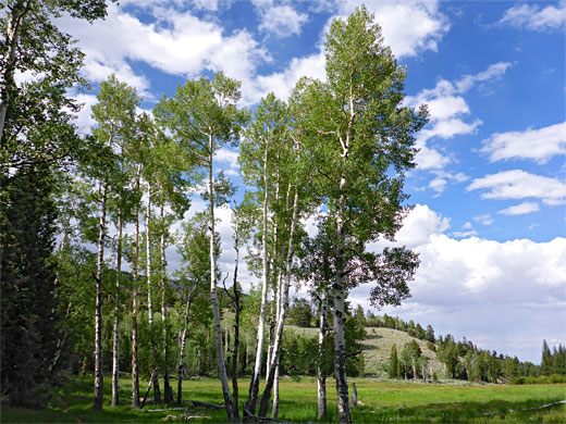
Baker Lake Road is a wide gravel road, suitable for all vehicles. The Johnson Lake hike starts from the southernmost of the two trailheads at the end of the road, the path first crossing the main fork of Baker Creek and soon reaching a junction; Timber Creek is left, South Fork Baker Creek right. This path stays fairly level for a short distance, across a moist meadow, passes over the south fork of the creek then starts a steep climb up the narrow, sloping ridge that separates this drainage from the main fork (audible though mostly out of sight), up through mixed woodland and past a connecting path to the Baker Creek Trail. The stream to the south is bordered by vertical, richly-colored reddish cliffs, though mostly hidden by trees. The gradient lessens quite abruptly as the path emerges from the woods to the edge of a wide meadow; it curves all around the west edge, and re-enters the forest whilst staying a little way west of the stream, winding through groves of large aspen trees interspersed with little sunny clearings.
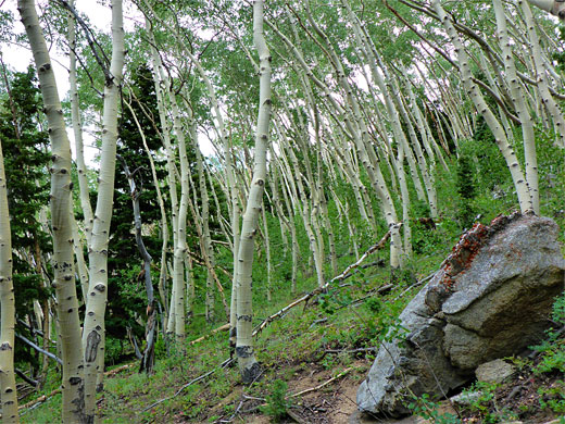
The trail moves closer to the creek for a while then further away again before crossing to the east side at the confluence with a tributary stream, which is followed through a band of wet trees and out to a widening meadow around the upper end of the creek, climbing over gradually drier ground to the junction with the Timber Creek Trail. The onwards route soon moves back into woodland - initially aspen then pine, crosses a tiny stream, one of the two forks of the tributary, and climbs through generally dark forest with little ground cover up to a saddle, on the ridge that divides the Baker Creek and Snake Creek drainages. A sign gives the distance to Johnson Lake as 2 miles.
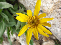
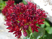
The mostly treeless ground on the saddle has a good mix of wildflowers, and affords fine views to the south; not so much to the north because of the trees. The trail then descends the exposed treeless slope below, enters a patch of aspen followed by a sizeable clearing, then more aspen trees, some uniformly bent downhill, presumably affected by past snow movements. The trail reaches a junction with the wider route from the Snake Creek Road, following the old vehicle track once used to reach the mine, and rises steeply, leveling out for a short distance, an area covered by many fallen trees, to a junction with a 0.6 mile path to Dead Lake, formed behind a terminal glacial moraine. This lake is also reached by a little-used path from Snake Creek Road.
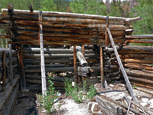
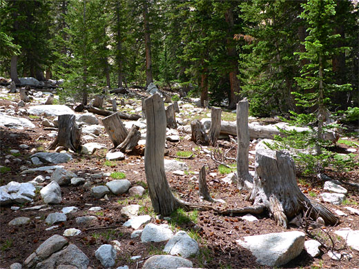
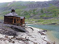
The path rises steeply again through aspen then pine, traversing slopes and eventually coming close to a broad valley to the south, and out to a sunny corner beside the photogenic remains of Johnston Mill, a timber building used to process the tungsten ore. The straight track continues to rise fairly gently, over two tiny creeks, to more buildings from the mine including the cookhouse, with metal roof still half intact, and several residential cabins. High-cut tree stumps tell of the deep snow during the construction of the buildings. An open, boulder-strewn corridor leads uphill to Johnson Lake, which is partly fed by a spring on the south side and partly by melting snow. Rusty iron relics are scattered around the muddy, grassy shoreline including a winch motor, a compression engine and a section of the aerial tramway.
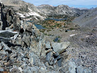
Several notices have information about my mine, the tunnels from which are about 400 feet above the lake to the southwest. The continuation path, not very well-defined, rises diagonally up the rocky slope, switchbacks south, coming close to one of the tunnels, and climbs again to a high point of 11,294 feet, on a broad, stony ridge, before descending toward Baker Lake. This hillside above Johnson Lake is covered by loose rocks and soft earth, often rather unstable, and as the route is not obvious in some parts, the traverse can be quite difficult.
Johnson Lake and Johnson Mine may be reached by three routes - the shortest and steepest trail starts from the end of Snake Creek Road, climbing 2,400 feet over 3.7 miles, while the longest (5.5 miles) and most varied, described below, begins from the large parking area at the end of Baker Creek Road, first following the South Fork of Baker Creek through woodland and meadows then climbing over a saddle on the ridge that divides the drainage from Snake Creek to the south, traversing more wooded slopes and climbing steadily to the lake. The third option (4.9 miles) starts at the same location but follows the shorter Timber Creek drainage before ascending to a junction just below the saddle. For the latter two routes, a loop can be made, another 7 miles, by crossing the ridge above Johnson Lake and returning via Baker Lake and the main fork of Baker Creek.
Maps
Overview map of Great Basin National Park, topographic map of the trail.
Photographs
30 views along the trail.
South Fork of Baker Creek
Baker Lake Road is a wide gravel road, suitable for all vehicles. The Johnson Lake hike starts from the southernmost of the two trailheads at the end of the road, the path first crossing the main fork of Baker Creek and soon reaching a junction; Timber Creek is left, South Fork Baker Creek right. This path stays fairly level for a short distance, across a moist meadow, passes over the south fork of the creek then starts a steep climb up the narrow, sloping ridge that separates this drainage from the main fork (audible though mostly out of sight), up through mixed woodland and past a connecting path to the Baker Creek Trail. The stream to the south is bordered by vertical, richly-colored reddish cliffs, though mostly hidden by trees. The gradient lessens quite abruptly as the path emerges from the woods to the edge of a wide meadow; it curves all around the west edge, and re-enters the forest whilst staying a little way west of the stream, winding through groves of large aspen trees interspersed with little sunny clearings.

Timber Creek Trail Junction
The trail moves closer to the creek for a while then further away again before crossing to the east side at the confluence with a tributary stream, which is followed through a band of wet trees and out to a widening meadow around the upper end of the creek, climbing over gradually drier ground to the junction with the Timber Creek Trail. The onwards route soon moves back into woodland - initially aspen then pine, crosses a tiny stream, one of the two forks of the tributary, and climbs through generally dark forest with little ground cover up to a saddle, on the ridge that divides the Baker Creek and Snake Creek drainages. A sign gives the distance to Johnson Lake as 2 miles.
Snake Creek Trail Junction
The mostly treeless ground on the saddle has a good mix of wildflowers, and affords fine views to the south; not so much to the north because of the trees. The trail then descends the exposed treeless slope below, enters a patch of aspen followed by a sizeable clearing, then more aspen trees, some uniformly bent downhill, presumably affected by past snow movements. The trail reaches a junction with the wider route from the Snake Creek Road, following the old vehicle track once used to reach the mine, and rises steeply, leveling out for a short distance, an area covered by many fallen trees, to a junction with a 0.6 mile path to Dead Lake, formed behind a terminal glacial moraine. This lake is also reached by a little-used path from Snake Creek Road.
Johnson Lake
The path rises steeply again through aspen then pine, traversing slopes and eventually coming close to a broad valley to the south, and out to a sunny corner beside the photogenic remains of Johnston Mill, a timber building used to process the tungsten ore. The straight track continues to rise fairly gently, over two tiny creeks, to more buildings from the mine including the cookhouse, with metal roof still half intact, and several residential cabins. High-cut tree stumps tell of the deep snow during the construction of the buildings. An open, boulder-strewn corridor leads uphill to Johnson Lake, which is partly fed by a spring on the south side and partly by melting snow. Rusty iron relics are scattered around the muddy, grassy shoreline including a winch motor, a compression engine and a section of the aerial tramway.
Pass above the Lake
Several notices have information about my mine, the tunnels from which are about 400 feet above the lake to the southwest. The continuation path, not very well-defined, rises diagonally up the rocky slope, switchbacks south, coming close to one of the tunnels, and climbs again to a high point of 11,294 feet, on a broad, stony ridge, before descending toward Baker Lake. This hillside above Johnson Lake is covered by loose rocks and soft earth, often rather unstable, and as the route is not obvious in some parts, the traverse can be quite difficult.
Johnson Lake and Baker Creek - Similar Hikes
All Contents © Copyright The American Southwest | Comments and Questions | Contribute | Affiliate Marketing Disclosure | Site Map