Arrastra Basin
High elevation basin containing a large lake (Silver Lake) lined with extensive old mine ruins; reached by a stony track, ending at another mine (Mayflower), and then a rough trail
Length: 3.8 miles if starting near Mayflower Mill, or 1.7 miles from near the end of the track
Elevation change: 2,750 feet, or 1,050 feet
Difficulty: Strenuous
Type: One way
Usage: Low; most people visit only Mayflower Mine, at the end of the track
Season: Summer and early fall
Trailhead: Along Hwy 2 near Mayflower Mill, or towards the end of Arrastra Gulch Road
Rating (1-5): ★★★★★
Elevation change: 2,750 feet, or 1,050 feet
Difficulty: Strenuous
Type: One way
Usage: Low; most people visit only Mayflower Mine, at the end of the track
Season: Summer and early fall
Trailhead: Along Hwy 2 near Mayflower Mill, or towards the end of Arrastra Gulch Road
Rating (1-5): ★★★★★

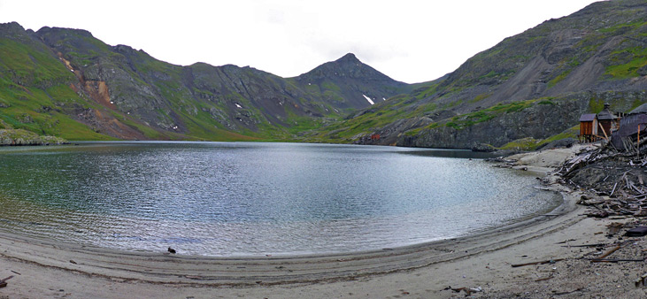
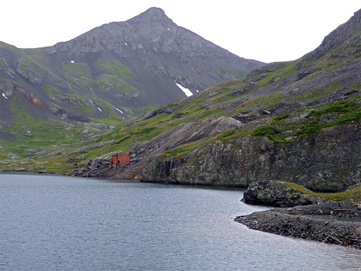
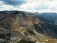
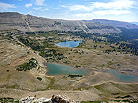
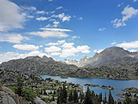
Arrastra Basin is one of dozens of high elevation valleys in the San Juan Mountains, surrounded by peaks and ridges on three sides, filled with Alpine wildflowers in summer, and made more unusual by containing a relatively large lake - Silver Lake - at an elevation of 12,186 feet. The basin is three miles southeast of Silverton, and like most of the mountains the surroundings are heavily mineralized and hence have been extensively mined, principally for gold and silver; there are four major mines around the lake, including dozens of shafts and adits, and many wooden or iron structures. All are long abandoned, but the aged, weather-beaten ruins add to the interest and photogenicity of the natural scenery. The easiest-reached and most extensive of the four is Silver Lake Mine, where the numerous relics are scattered over 600 feet of the northern shoreline.
The area is buried beneath deep snow for several months in winter and spring, and is subject to rough weather most of the year including frequent thunderstorms in summer, so the basin is not always easy to reach. The route to the lake starts at the end of the paved part of the road (Hwy 2) northeast of Silverton; one of three unpaved forks crosses the Animas River and climbs Arrastra Gulch to the south, gradually deteriorating and ending after 2.6 miles at the remains of the smaller Mayflower Mine, from where a trail climbs 1,050 feet over 1.2 miles to the basin.
Large vehicles like RVs have to be left at a verge along the paved road, while the final half mile of the track is only for ATVs or similar, however other vehicles will be able to drive at least part of the way. If starting from the paved road, the elevation gain is 2,750 feet.
San Juan Mountains area map, Arrastra Basin topographic map.
53 views along the track/trail to Arrastra Basin.
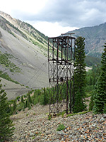
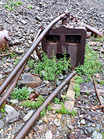
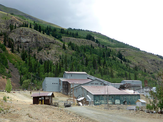
The road from Silverton (Hwy 2) becomes unpaved after 2 miles, just before a three-way junction where the left fork accesses the nearby Mayflower Mill. Now a National Historic Landmark, this imposing structure contains machinery used to extract gold and other metals from the nearby mines, and was in operation from 1930 to 1991; it is preserved as a museum, and open to the public each year from June to the start of September. The middle fork of the road, the most used, continues to other locations further up the Animas River valley, while the right branch (Arrastra Gulch Road, Hwy 21) is to Mayflower Mine and the trail to Arrastra Basin. This track descends to the river, where other routes (once part of the Silverton Northern Railroad) lead up and downstream, crosses on a bridge and rises along the narrow valley of Arrastra Creek, through thick forest of pine and aspen. A spur, signed 20A, leads to a house, while the track climbs more steeply, soon becoming quite high above the stream. A wooden dam can be seen along the creek below. The road passes a grassy flat on the left, marked with a 'Private' notice, then a second grassy clearing, sometimes used for primitive camping. The track steepens again, up to the junction with a private driveway on the right, and then with another track, also on the right, which descends to the valley floor, and is signed '52', ending in half a mile at another old mine. Keeping left (east) the most used route continues climbing and passes under a tramway line that was built in the 1920s to carry rocks from Mayflower Mine to the mill. All the towers and cables are still in situ, with a few ore buckets suspended at intervals.
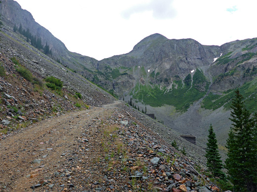
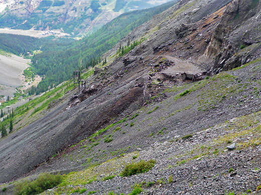
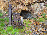
The road crosses a scree slope, past a junction on the left with a track into the adjacent valley northwards (Little Giant Basin), then re-enters the forest. It crosses three streams, one flowing through a rockslide corridor, then leaves the trees for the last time, now heading across more extensive scree slopes. The views open up dramatically, revealing the very steep cliffs all around the head of the valley, and many pieces of iron debris scattered over the lower slopes, plus a few standing structures, beside mineshafts. A long straight section extends to the foot of much steeper ground at the upper end of Arrastra Gulch, and a small parking area where most vehicles have to stop, since the last portion of the road is significantly steeper, and the surface partly formed of large, loose rocks. The track switchbacks north and finally back south, ending at Mayflower Mine, elevation 11,200 feet. Just below the mine are the uppermost two towers of the ore tramway, each just downhill of a diamond shaped structure made of stone, designed as protection from avalanches, while the actual mine site is marked by sizeable piles of rusting iron objects, wooden planks and other detritus; all heavily mangled by the combined effects of snow and rock falls. The main adit at the mine is sealed by concrete.
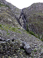
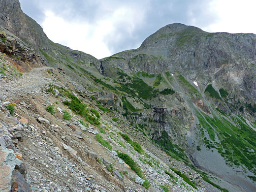
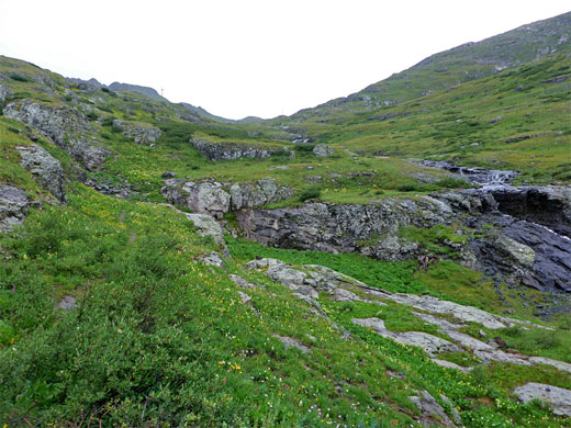
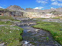
The Arrastra Basin continuation path, which seems to be unmaintained, is narrow and difficult to follow in some places. The trail climbs steeply right from the start, and is initially straight before switchbacking eastwards while ascending more loose scree, then moving back south and approaching the cliffs that form a dramatic backdrop to the lower part of the valley, where Arrastra Creek forms a tall, narrow waterfall. The path has partly eroded away beneath one rocky area, and just beyond is a little gulley where an old iron cable assists when climbing. Above here the path reaches the edge of Arrastra Basin, where the land flattens out abruptly, becoming predominantly grassy. The stream flows gently through pools and cascades, all lined by many species of wildflowers. At least one adit is passed on the left, not sealed. After a briefly steeper section, the path rises up the last minor slope and over a brow to the north edge of Silver Lake, a detached section that is separated from the main lake by a semi-submerged sand bar. Many small pieces of iron and wood are scattered along the exit stream, washed down from the surrounding mine ruins.
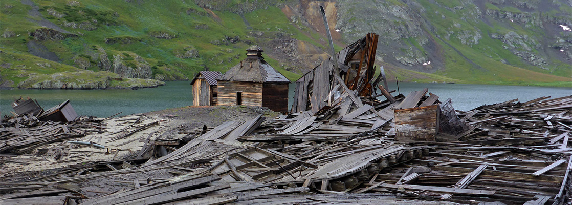
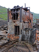
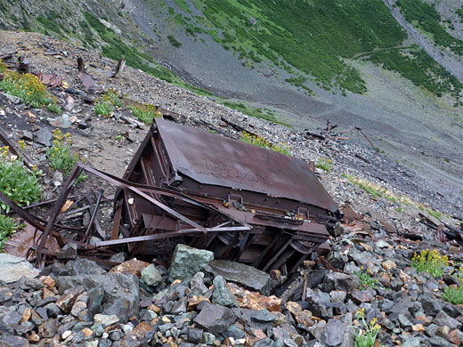
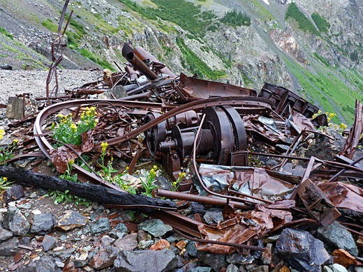
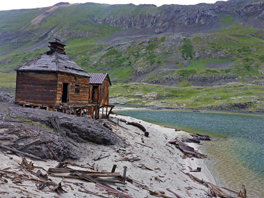
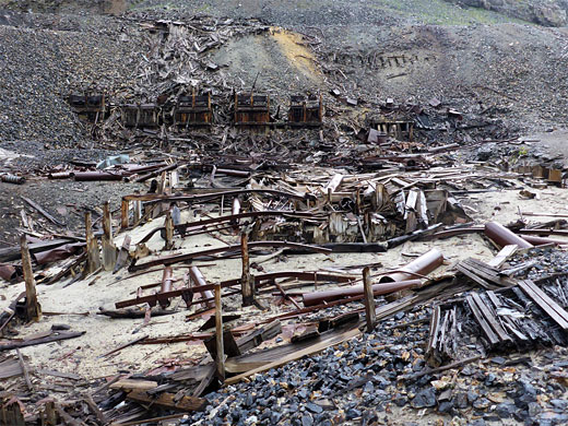
Silver Lake Mine is situated on the northwest edge of the main part of the lake, and it contains a few structures that are still standing, and others partially collapsed, but most are completely flattened, forming a great disorderly mass of timber, stone and metal, mixed with various smaller items including glass fragments (often colored), ceramics, tiles, shoes, tins and bones. Inside some of the intact buildings are furniture such as beds, tables, benches and cupboards, still containing objects. Two buildings, holding boilers, are built of brick and so seem destined to outlast all the others. There is much to see around the mine, and the ruined structures look quite different from various angles. The whole place is very bleak and eerie, especially when the weather is stormy. The next nearest mine (Iowa) is a thousand feet further south along the lakeshore, reached by a rather longer route that climbs to avoid low cliffs and loose scree.
The area is buried beneath deep snow for several months in winter and spring, and is subject to rough weather most of the year including frequent thunderstorms in summer, so the basin is not always easy to reach. The route to the lake starts at the end of the paved part of the road (Hwy 2) northeast of Silverton; one of three unpaved forks crosses the Animas River and climbs Arrastra Gulch to the south, gradually deteriorating and ending after 2.6 miles at the remains of the smaller Mayflower Mine, from where a trail climbs 1,050 feet over 1.2 miles to the basin.
Large vehicles like RVs have to be left at a verge along the paved road, while the final half mile of the track is only for ATVs or similar, however other vehicles will be able to drive at least part of the way. If starting from the paved road, the elevation gain is 2,750 feet.
Location
San Juan Mountains area map, Arrastra Basin topographic map.
Photographs
53 views along the track/trail to Arrastra Basin.
Road up Arrastra Creek
The road from Silverton (Hwy 2) becomes unpaved after 2 miles, just before a three-way junction where the left fork accesses the nearby Mayflower Mill. Now a National Historic Landmark, this imposing structure contains machinery used to extract gold and other metals from the nearby mines, and was in operation from 1930 to 1991; it is preserved as a museum, and open to the public each year from June to the start of September. The middle fork of the road, the most used, continues to other locations further up the Animas River valley, while the right branch (Arrastra Gulch Road, Hwy 21) is to Mayflower Mine and the trail to Arrastra Basin. This track descends to the river, where other routes (once part of the Silverton Northern Railroad) lead up and downstream, crosses on a bridge and rises along the narrow valley of Arrastra Creek, through thick forest of pine and aspen. A spur, signed 20A, leads to a house, while the track climbs more steeply, soon becoming quite high above the stream. A wooden dam can be seen along the creek below. The road passes a grassy flat on the left, marked with a 'Private' notice, then a second grassy clearing, sometimes used for primitive camping. The track steepens again, up to the junction with a private driveway on the right, and then with another track, also on the right, which descends to the valley floor, and is signed '52', ending in half a mile at another old mine. Keeping left (east) the most used route continues climbing and passes under a tramway line that was built in the 1920s to carry rocks from Mayflower Mine to the mill. All the towers and cables are still in situ, with a few ore buckets suspended at intervals.
Mayflower Mine
The road crosses a scree slope, past a junction on the left with a track into the adjacent valley northwards (Little Giant Basin), then re-enters the forest. It crosses three streams, one flowing through a rockslide corridor, then leaves the trees for the last time, now heading across more extensive scree slopes. The views open up dramatically, revealing the very steep cliffs all around the head of the valley, and many pieces of iron debris scattered over the lower slopes, plus a few standing structures, beside mineshafts. A long straight section extends to the foot of much steeper ground at the upper end of Arrastra Gulch, and a small parking area where most vehicles have to stop, since the last portion of the road is significantly steeper, and the surface partly formed of large, loose rocks. The track switchbacks north and finally back south, ending at Mayflower Mine, elevation 11,200 feet. Just below the mine are the uppermost two towers of the ore tramway, each just downhill of a diamond shaped structure made of stone, designed as protection from avalanches, while the actual mine site is marked by sizeable piles of rusting iron objects, wooden planks and other detritus; all heavily mangled by the combined effects of snow and rock falls. The main adit at the mine is sealed by concrete.
Trail to Arrastra Basin
The Arrastra Basin continuation path, which seems to be unmaintained, is narrow and difficult to follow in some places. The trail climbs steeply right from the start, and is initially straight before switchbacking eastwards while ascending more loose scree, then moving back south and approaching the cliffs that form a dramatic backdrop to the lower part of the valley, where Arrastra Creek forms a tall, narrow waterfall. The path has partly eroded away beneath one rocky area, and just beyond is a little gulley where an old iron cable assists when climbing. Above here the path reaches the edge of Arrastra Basin, where the land flattens out abruptly, becoming predominantly grassy. The stream flows gently through pools and cascades, all lined by many species of wildflowers. At least one adit is passed on the left, not sealed. After a briefly steeper section, the path rises up the last minor slope and over a brow to the north edge of Silver Lake, a detached section that is separated from the main lake by a semi-submerged sand bar. Many small pieces of iron and wood are scattered along the exit stream, washed down from the surrounding mine ruins.
Silver Lake Mine
Silver Lake Mine is situated on the northwest edge of the main part of the lake, and it contains a few structures that are still standing, and others partially collapsed, but most are completely flattened, forming a great disorderly mass of timber, stone and metal, mixed with various smaller items including glass fragments (often colored), ceramics, tiles, shoes, tins and bones. Inside some of the intact buildings are furniture such as beds, tables, benches and cupboards, still containing objects. Two buildings, holding boilers, are built of brick and so seem destined to outlast all the others. There is much to see around the mine, and the ruined structures look quite different from various angles. The whole place is very bleak and eerie, especially when the weather is stormy. The next nearest mine (Iowa) is a thousand feet further south along the lakeshore, reached by a rather longer route that climbs to avoid low cliffs and loose scree.
Arrastra Basin Wildflowers
More flowers along the trail
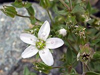 Spreading sandwort |
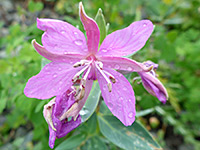 Dwarf fireweed |
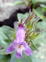 Harbour's beardtongue |
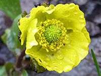 Rocky Mountain buttercup |
More flowers along the trail
Arrastra Basin - Similar Hikes
All Contents © Copyright The American Southwest | Comments and Questions | Contribute | Affiliate Marketing Disclosure | Site Map