Bristlecone and Glacier Trail, Great Basin National Park
Nevada > Great Basin National Park > Bristlecone and Glacier Trail
Bristlecone and Glacier Trail
Path through woodland, up a ravine, past a grove of bristlecone pines to the extensive moraine below the rock glacier at the foot of Wheeler Peak. Many wildflowers in summer, and good views along the upper reaches
Length: 1.4 miles to the pines, up to 2.5 miles for the glacier
Elevation change: 600 feet, 1,100 feet
Difficulty: Easy, moderate
Type: One-way
Usage: Medium
Season: Summer and early fall
Trailhead: Parking area near the end of the scenic drive
Rating (1-5): ★★★★★
Elevation change: 600 feet, 1,100 feet
Difficulty: Easy, moderate
Type: One-way
Usage: Medium
Season: Summer and early fall
Trailhead: Parking area near the end of the scenic drive
Rating (1-5): ★★★★★

Perhaps the best of the shorter hikes in Great Basin National Park, the Bristlecone and Glacier Trail climbs a wooded slope, moving above the regular tree line to an isolated group of bristlecone pines, surrounded by rocky slopes at the mouth of a broad ravine, then continues over boulders and scree to the base of Nevada's only glacier, in a cirque at the foot of Wheeler Peak, sheltered by steep cliffs to the west, south and east. In mid to late summer when the snowfield has retreated the hike can extend right to the cliffs, though the official trail ends about a quarter of a mile back.
Besides the pines, the glacier and the cliffs, the trail also passes a good variety of Alpine wildflowers, mostly in the open rocky areas, and has grand views to the north, towards the distant Snake Valley. The path starts near the campground at the far end of the Wheeler Peak Scenic Drive, sharing the first 0.6 miles with the Alpine Lakes Loop.
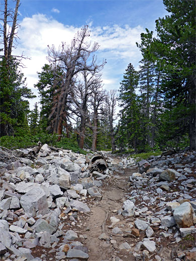
The Wheeler Peak Campground trailhead parking area has an elevation of 9,960 feet, and is usually accessible between June and October. The one path, the Alpine Loop Trail, enters the pine forest, crosses a stream and soon forks; the left branch zigzags up a wooded slope, over a second small stream at one point, and reaches another junction after 0.6 miles, at the start of the Bristlecone and Glacier Trail, signed 0.7 miles to the pines, 1.65 miles to the glacier. This route heads down a rocky gully, with a scree slope above to the south, then enters thicker woodland, traversing a hillside, round a corner and turning south, where gaps in the trees allow the first proper views of the wider landscape far below. A little way off trail to the east, though out of sight, is Brown Lake, a small pond with no outlet, fed by melting snow.
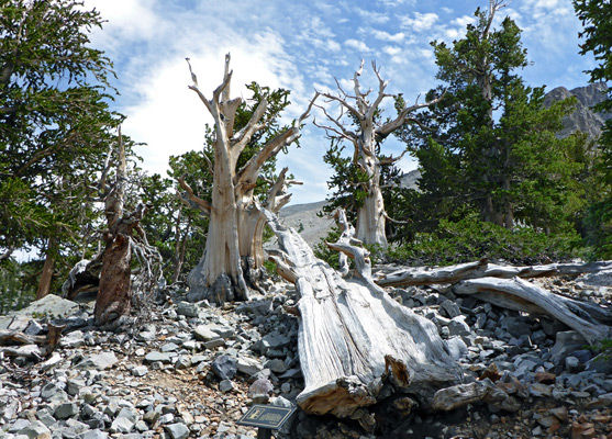
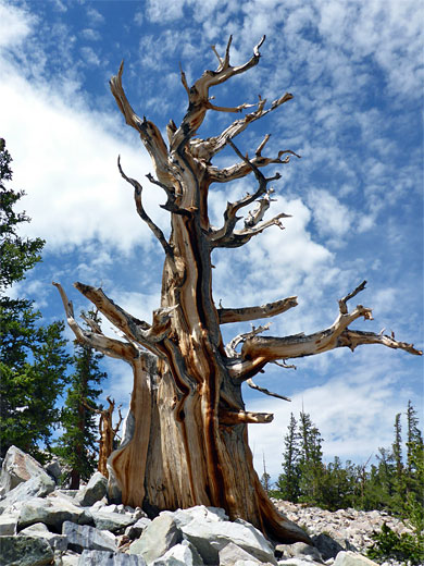
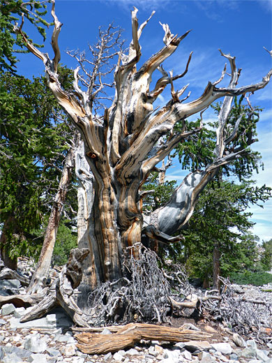
The trail continues through thinning trees, crosses an open, boulder-strewn streambed, climbing by one switchback up the far side to somewhat flatter ground, location of the bristlecone pine grove. A very short (0.1 mile) side path loops through some of the larger trees, many of which appear dead, barkless and leafless, though still very photogenic, with richly-colored, reddish-brown wood and angular outlines. Signs give information about some of the trees, the most ancient of which is 3,200 years old. Big, jumbled quartzite boulders lie all around. This is by far the most accessible of three groups of bristlecone pines in the national park; the other two are near the top of Mount Washington, a few miles south, and below the summit of Eagle Peak, between the Brown Creek and Snake Creek valleys.
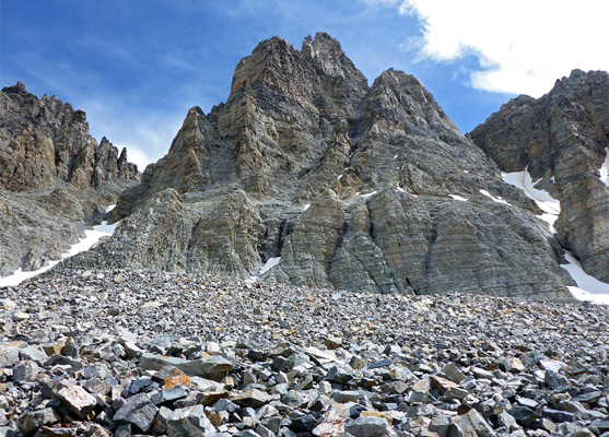
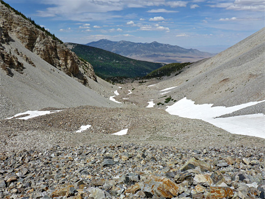
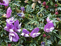
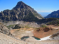
Past the pines, the Glacier Trail proceeds further south up the ravine, climbing steadily but not too steeply, past the last few straggly trees and into a stark landscape of boulders and snow, with occasional small patches of sandy soil that support many small-flowered plant species such as alpine avens, dwarf alpine indian paintbrush, dwarf phlox, little-leaf alumroot, rockslide daisy, sky pilot and spiny milkvetch, plus just a few larger blooms like alpine gold. The trail ascends progressively higher boulder piles, sometimes crossing areas of snow, gradually becoming less used and less well-defined. Dramatic, weathered, cracked, snowy cliffs rise up on three sides, topped by the summits of Wheeler Peak and Jeff Davis Peak. The permanent snowfield below Wheeler Peak is generally regarded as a rock glacier rather than a true glacier, since it has a high proportion of rock relative to ice, a characteristic only evident in late summer once the seasonal snow covering has melted.
Besides the pines, the glacier and the cliffs, the trail also passes a good variety of Alpine wildflowers, mostly in the open rocky areas, and has grand views to the north, towards the distant Snake Valley. The path starts near the campground at the far end of the Wheeler Peak Scenic Drive, sharing the first 0.6 miles with the Alpine Lakes Loop.
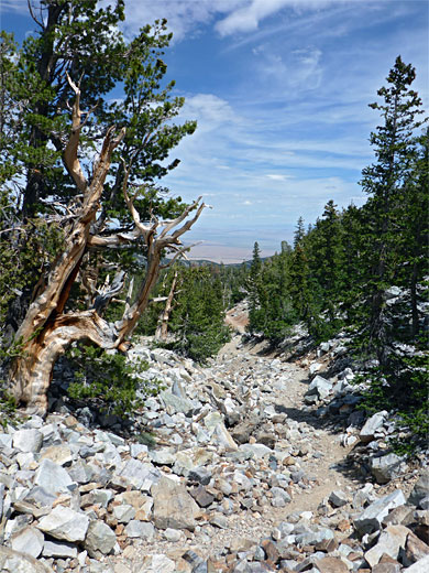
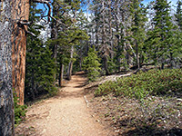
Start of the Bristlecone Trail
The Wheeler Peak Campground trailhead parking area has an elevation of 9,960 feet, and is usually accessible between June and October. The one path, the Alpine Loop Trail, enters the pine forest, crosses a stream and soon forks; the left branch zigzags up a wooded slope, over a second small stream at one point, and reaches another junction after 0.6 miles, at the start of the Bristlecone and Glacier Trail, signed 0.7 miles to the pines, 1.65 miles to the glacier. This route heads down a rocky gully, with a scree slope above to the south, then enters thicker woodland, traversing a hillside, round a corner and turning south, where gaps in the trees allow the first proper views of the wider landscape far below. A little way off trail to the east, though out of sight, is Brown Lake, a small pond with no outlet, fed by melting snow.
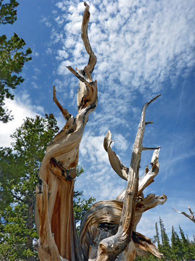
Bristlecone Pines
The trail continues through thinning trees, crosses an open, boulder-strewn streambed, climbing by one switchback up the far side to somewhat flatter ground, location of the bristlecone pine grove. A very short (0.1 mile) side path loops through some of the larger trees, many of which appear dead, barkless and leafless, though still very photogenic, with richly-colored, reddish-brown wood and angular outlines. Signs give information about some of the trees, the most ancient of which is 3,200 years old. Big, jumbled quartzite boulders lie all around. This is by far the most accessible of three groups of bristlecone pines in the national park; the other two are near the top of Mount Washington, a few miles south, and below the summit of Eagle Peak, between the Brown Creek and Snake Creek valleys.
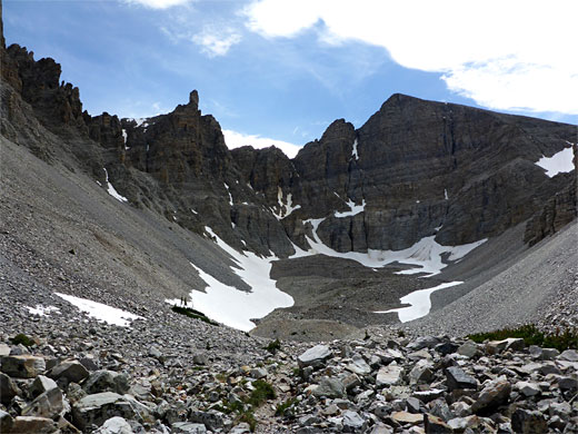
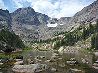
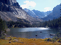
The Glacier
Past the pines, the Glacier Trail proceeds further south up the ravine, climbing steadily but not too steeply, past the last few straggly trees and into a stark landscape of boulders and snow, with occasional small patches of sandy soil that support many small-flowered plant species such as alpine avens, dwarf alpine indian paintbrush, dwarf phlox, little-leaf alumroot, rockslide daisy, sky pilot and spiny milkvetch, plus just a few larger blooms like alpine gold. The trail ascends progressively higher boulder piles, sometimes crossing areas of snow, gradually becoming less used and less well-defined. Dramatic, weathered, cracked, snowy cliffs rise up on three sides, topped by the summits of Wheeler Peak and Jeff Davis Peak. The permanent snowfield below Wheeler Peak is generally regarded as a rock glacier rather than a true glacier, since it has a high proportion of rock relative to ice, a characteristic only evident in late summer once the seasonal snow covering has melted.
Glacier Trail Wildflowers
More flowers along the trail
 Spiny milkvetch |
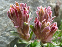 Dwarf alpine indian paintbrush |
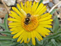 Alpine gold |
More flowers along the trail
Bristlecone and Glacier Trail - Similar Hikes
All Contents © Copyright The American Southwest | Comments and Questions | Contribute | Affiliate Marketing Disclosure | Site Map