Idaho - Introduction to the Parks and Landscapes
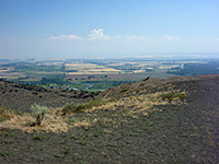
Idaho is primarily a mountainous state, containing the central part of the northern Rockies, which stretch from the southeast northwards to the Canadian border. Only the southwest is an exception as here the land is flat and lower in elevation (below 3,000 feet in some parts), and dominated by the Snake River Plain. This wide river corridor forms a great arc from Idaho Falls in the east to Boise in the west and is home to the majority of the state's inhabitants. Most of the northern two thirds of Idaho is lightly settled and not very accessible; the only other significant population center is in the far northwest, including such towns as Lewiston, Moscow and Coeur d'Alene.
Although the mountains of the north and center are very extensive, and high, the majority is densely wooded and there are few dramatic rocky summits or gorges so the region is not well traveled, and there are no National Park Service units here - instead all is part of national forests, and the majority is designated wilderness. The only national preserve in the north is Hells Canyon National Recreation Area, administered by the USFS and containing over 100 miles of the deepest canyon in the US, up to 7,000 feet. A few paved roads cross the NRA but the canyon itself is rather inaccessible, reachable for the most part only by long distance hiking.

Instead, most of Idaho's well-known scenic areas are in the south, on or near the Snake River Plain. In the far east, the state contains a small section of Yellowstone National Park, and the access road to Cascade Corner (Cave Falls Road). The mountains of neighboring Wyoming extend a little way west and include several smaller sites such as Big Springs (a first magnitude spring creating a full-size river), Island Park (flat land at the center of an ancient volcano), Mesa Falls (a pair of dramatic waterfalls in a deep canyon), Soda Springs (a collection of hot pools, along the Oregon Trail), and Bear Lake, this latter extending across the border into Utah.
The most visible geological component of the Snake River Plain is lava, as the valley lies above a lengthy rift zone and has seen numerous eruptions over a period of many millions of years, with the center of activity gradually moving northeast, currently positioned under Yellowstone National Park. The best place to view volcanic features close up is at Craters of the Moon National Monument and Preserve, along US 26 near Arco, where a scenic drive and several short trails lead to cinder clones, spatter cones, lava caves and tree moulds.
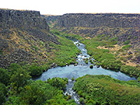
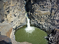
The Snake River cuts many dark-walled canyons through the basalt bedrock, seen for example in the various units of Thousand Springs State Park near Twin Falls; another characteristic of the river are the many springs that emerge at the base of individual lava layers, either alongside the river itself or at the head of short box canyon tributaries. Cinder cones and craters dot the landscape all across the valley; one other site of note is the Menan Buttes, a pair of symmetric summits near Idaho Falls. The northern butte is open to the public and has a trail to the top. The majority of the state's volcanic features are undesignated and undeveloped, but as nearly all lie on public lands they are open to off trail exploration.
The Thousands Springs are also close to an NPS preserve, the small Hagerman Fossil Beds National Monument in which are found outcrops of geologically important fossiliferous rocks, though apart from a couple of overlooks and a short trail, there is little to see for the casual visitor. Much more interesting is City of Rocks National Reserve in the far south, near the Utah stateline. This rather remote location features several square miles of fantastic, eroded granite formations - spires, narrow ridges, sheer-walled canyons and natural arches, and the place is quite popular, for camping, hiking and rock climbing. This lies at the northern border of the Great Basin Desert, which, to the east, extends northwards a little way towards Pocatello. In the other direction, the far southwest of Idaho is hilly, virtually uninhabited, and crossed by only one paved road, Hwy 51 from Elko, NV. This land of isolated mountains, branched canyons and high desert plains (the Owyhee Plateau), merges with the equally empty deserts of southeast Oregon; a 200 mile wide expanse that offers endless possibilities for backcountry exploration.
The Snake River cuts many dark-walled canyons through the basalt bedrock, seen for example in the various units of Thousand Springs State Park near Twin Falls; another characteristic of the river are the many springs that emerge at the base of individual lava layers, either alongside the river itself or at the head of short box canyon tributaries. Cinder cones and craters dot the landscape all across the valley; one other site of note is the Menan Buttes, a pair of symmetric summits near Idaho Falls. The northern butte is open to the public and has a trail to the top. The majority of the state's volcanic features are undesignated and undeveloped, but as nearly all lie on public lands they are open to off trail exploration.
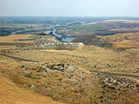
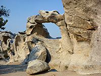
The Thousands Springs are also close to an NPS preserve, the small Hagerman Fossil Beds National Monument in which are found outcrops of geologically important fossiliferous rocks, though apart from a couple of overlooks and a short trail, there is little to see for the casual visitor. Much more interesting is City of Rocks National Reserve in the far south, near the Utah stateline. This rather remote location features several square miles of fantastic, eroded granite formations - spires, narrow ridges, sheer-walled canyons and natural arches, and the place is quite popular, for camping, hiking and rock climbing. This lies at the northern border of the Great Basin Desert, which, to the east, extends northwards a little way towards Pocatello. In the other direction, the far southwest of Idaho is hilly, virtually uninhabited, and crossed by only one paved road, Hwy 51 from Elko, NV. This land of isolated mountains, branched canyons and high desert plains (the Owyhee Plateau), merges with the equally empty deserts of southeast Oregon; a 200 mile wide expanse that offers endless possibilities for backcountry exploration.
All Contents © Copyright The American Southwest | Comments and Questions | Contribute | Affiliate Marketing Disclosure | Site Map