Cascade Corner, Yellowstone National Park
Wyoming > Yellowstone National Park > The Southwest > Cascade Corner
Highlights:
Meadows, creeks and waterfalls in the far southwest corner of Yellowstone National Park, south of the Madison Plateau and the Pitchstone Plateau, centered on the Bechler and Falls rivers. A relatively low elevation, little visited region

Cascade Corner is the name given to the far southwest section of Yellowstone National Park, beyond the edge of Pitchstone Plateau which occupies most of the area eastwards as far as Shoshone Lake and the Lewis River, and Madison Plateau to the north.
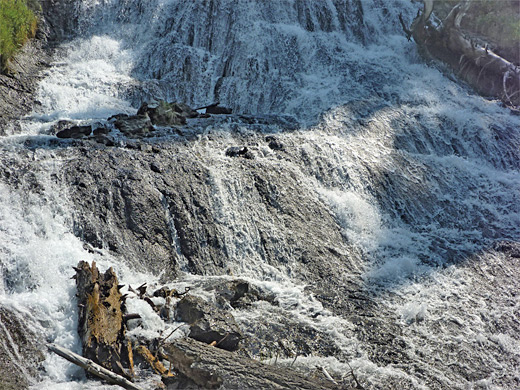
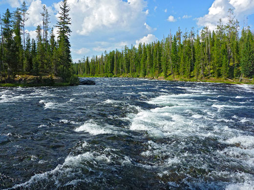
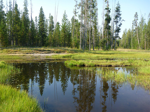
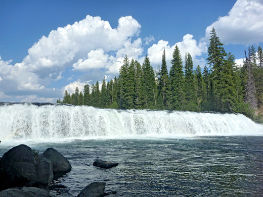
Also known generally as Bechler, the region is relatively low in elevation, around 6,400 feet, and most is flat, a varied mixture of meadows, creeks, sloughs, marshes and forest; there are few thermal features, and instead the main attractions are waterfalls - over 20 are found here, most along the Falls River and its tributaries, others along the Bechler River and Boundary Creek.
The majority need rather a long hike to reach, up to 15 miles, hence the region is popular with backpackers, and also notable because of the abundant wildlife (moose, beaver, wolves and black bears), the rather longer hiking season (approximately from May to November) and the general remoteness.
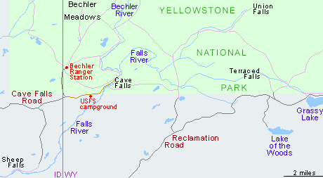
Cascade Corner is not accessible by road from the rest of the park, cut off by mountain ranges and river canyons, and instead access is via the 19 mile Cave Falls Road, crossing Targhee National Forest land, starting at a junction with Hwy 47. Facilities at Bechler are limited to a ranger station, a few trailheads and the nearby USFS campground, and a typical weekday in summer may see only a few dozen visitors.
Also known generally as Bechler, the region is relatively low in elevation, around 6,400 feet, and most is flat, a varied mixture of meadows, creeks, sloughs, marshes and forest; there are few thermal features, and instead the main attractions are waterfalls - over 20 are found here, most along the Falls River and its tributaries, others along the Bechler River and Boundary Creek.
The majority need rather a long hike to reach, up to 15 miles, hence the region is popular with backpackers, and also notable because of the abundant wildlife (moose, beaver, wolves and black bears), the rather longer hiking season (approximately from May to November) and the general remoteness.
Cascade Corner is not accessible by road from the rest of the park, cut off by mountain ranges and river canyons, and instead access is via the 19 mile Cave Falls Road, crossing Targhee National Forest land, starting at a junction with Hwy 47. Facilities at Bechler are limited to a ranger station, a few trailheads and the nearby USFS campground, and a typical weekday in summer may see only a few dozen visitors.
Cascade Corner Table of Contents
Photographs
Cave Falls and Bechler Falls, Dunanda Falls and Silver Scarf Falls
Videos
Cave Falls and Bechler Falls, Dunanda Falls and Silver Scarf Falls.
Cave Falls Road
The access road, which is not signposted to Yellowstone National Park, forks off Hwy 47 just east of Ashton, Idaho. The route is paved for a while, crossing peaceful farmland, then becomes unpaved at the national forest boundary, after which the surface is rather stony and ridged (and dusty when dry), though still fine for all vehicles. The wide track follows the open valleys of Porcupine Creek and Rock Creek then enters pine woodland, passing two turn-offs, one north to Horseshoe Lake, the other south to the trailhead for the 1.3 mile hike to Sheep Falls on the Falls River. 0.9 miles along this latter road is a good area for primitive camping, in a big, grassy clearing in the woods on the north side of Wyoming Creek. There are also several lesser tracks branching off the main road leading to other potential camp spots, while for official stays, the USFS manage Cave Falls campground, shortly before the end of the road.
Bechler Ranger Station
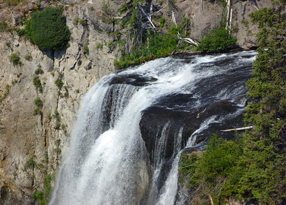
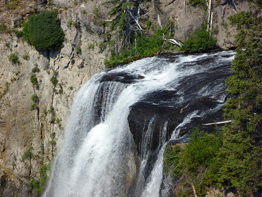
Cave Falls Road forks just after crossing from Idaho into Wyoming. The left turn soon reaches the Bechler Ranger Station, and the main Cascade Corner trailhead, where four paths begin, namely the West Boundary Trail, Bechler Meadows/Boundary Creek Trail to Dunanda Falls and beyond, and two connecting trails eastwards to different parts of the Bechler River Trail. From the junction, the other road (now paved, but narrow) continues east another 3 miles to a small parking area near Cave Falls, start point of the Bechler River Trail that heads north, passing Bechler Falls in 1.3 miles and continuing to many other locations including Colonnade Falls after ten miles.
Reclamation Road
There are four other trailheads in the Cascade Corner region, east of the Falls River and reached by an unconnected route, Reclamation Road, also known as Ashton-Flagg Ranch Road or Grassy Lake Road. This links US 89 between the Grand Teton and Yellowstone national parks (within the Newton B Drury Scenic Parkway), with Ashton. The road is well used and regularly maintained, though a little rough in places. The easternmost 9 miles is within the parkway and has about ten designated (free) camping sites, but the remainder crosses national forest land where camping is allowed anywhere. Trailheads are to Beula Lake (2.5 miles), the Mountain Ash Creek Trail (to Union Falls, and connecting with the Bechler River Trail), to Terraced Falls (1.2 miles), and the South Boundary Trail. All are infrequently used, less even than the two trailheads along Cave Falls Road. Most traffic along Reclamation Road is either campers, or people visiting Grassy Lake and nearby Lake of the Woods.
Tours of Yellowstone
Hiking in Cascade Corner
All trails in Yellowstone's southwest
Featured Trails
Boundary Creek
★★★★★
★★★★★
8.4 miles, 350 feet (to Dunanda Falls)
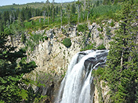
From the Bechler River ranger station, a trail passes through flat forest and meadowland for 8 miles to the edge of a plateau, where the creek enters a ravine and flows over 150 foot Dunanda Falls. A nearby side canyon contains the 250 foot Silver Scarf Falls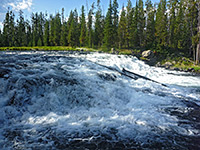
Bechler Falls
★★★★★
★★★★★
1.3 miles, 60 feet
This short hike follows the southernmost section of the Bechler River Trail starting at Cave Falls, past the Bechler River-Falls River confluence to Bechler Falls, a small waterfall but still quite powerfulAll Contents © Copyright The American Southwest | Comments and Questions | Contribute | Affiliate Marketing Disclosure | Site Map