Trails in Black Canyon of the Gunnison National Park
Colorado > Black Canyon of the Gunnison National Park > Hiking
The Black Canyon of the Gunnison National Park map indicates the location of all trails.

Black Canyon of the Gunnison Trails - Maintained Paths
|
Cedar Point Nature Trail Length 0.3 miles (0.5 km) Elevation change 50 feet (15 meters) Trailhead Parking area towards the west end of the park road Rating (1-5) ★★★★★ Cedar Point is an overlook near the far (west) end of the South Rim park road, with good views downstream, across Painted Wall and Dragon Point, westwards towards the less steep lower section of the canyon. The short path to the viewpoint descends slightly as it crosses to the edge of the wooded plateau. |
|
Chasm View Nature Trail Length 0.4 miles (0.6 km) (loop) Elevation change 20 feet (6 meters) Trailhead At the North Rim campground Rating (1-5) ★★★★★ The only short path on the North Rim starts at the entrance to the campground and loops across the plateau to the south, passing two railing-protected viewpoints and running right along the canyon edge for a short distance. This location is directly opposite Chasm View on the South Rim; both points overlook the narrowest section of the gorge. |
|
Deadhorse Trail Length 2.5 miles (4 km) Elevation change 300 feet (91 meters) Trailhead Kneeling Camel Overlook, along the North Rim Road Rating (1-5) ★★★★★ The Deadhorse Trail, the least used rim path in the park, follows an old forest track so the route is wide, easy and mostly level. It heads generally southeast along the North Rim, climbing gently, past several canyon viewpoints before ending at an overlook above a major tributary ravine (Deadhorse Gulch). |
North Vista Trail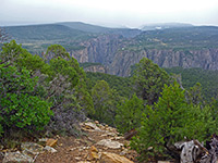 Length 3.5 miles (5.6 km) Elevation change 860 feet (262 meters) Trailhead At the North Rim ranger station Rating (1-5) ★★★★★ The longest trail in the national park explores the western section of the North Rim, starting at the ranger station near the end of the park road and climbing, gently at first then more steeply, via several long switchbacks, up to the summit of 8,563 foot Green Mountain. About half way along, a short spur leads to an overlook (Exclamation Point) right on the canyon rim, above one of the most sheer-walled sections of the whole gorge. |
|
Oak Flat Loop Length 2 miles (3.2 km) (loop) Elevation change 400 feet (122 meters) Trailhead At the visitor center Rating (1-5) ★★★★★ Starting near the South Rim visitor center, the Oak Flat Loop Trail descends just a little way below the canyon rim, winding through a mix of oak//fir/aspen woodland and open, rocky areas with views to the river far below, both upstream and downstream. The return part of the loop is through generally less wooded terrain close to the road. |
|
Rim Rock Nature Trail Length 0.5 miles (0.8 km) Elevation change level Trailhead Loop C of the campground Rating (1-5) ★★★★★ This level path starts at the South Rim campground and heads north along the canyon rim, ending at a projecting overlook (Tomichi Point, also reachable by road). Besides views of the canyon, the path is also good for inspecting the local plant life, assisted by interpretive notices at intervals. |
Warner Point Nature Trail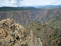 Length 0.7 miles (1.1 km) Elevation change 150 feet (46 meters) Trailhead West end of the park scenic drive (High Point) Rating (1-5) ★★★★★ Starting at the far end of the park road, this trail follows the rim a little way further west, first descending slightly to a saddle then rising a little more, to a flat-topped summit at 8,302 feet. The views are very extensive, both north to the canyon and south towards Montrose, and the path passes a good variety of vegetation. |
Black Canyon of the Gunnison Trails - Rim to River Routes
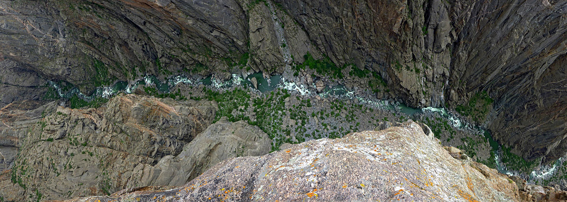
Gunnison Route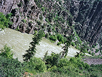 Length 1 miles (1.6 km) Elevation change 1800 feet (549 meters) Trailhead At the visitor center Rating (1-5) ★★★★★ Unmaintained route vertically down the precipitous cliffs of Black Canyon, all the way to the river - aided over one 80 meter stretch by a metal chain. Loose rocks underfoot. Considered the easiest of the six such trails, but still very strenuous. |
Long Draw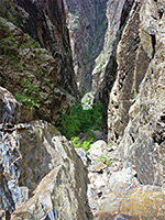 Length 1 miles (1.6 km) including the short road walk at the start Elevation change 1800 feet (549 meters) Trailhead Balanced Rock Overlook; trail begins 0.3 miles east along the road Rating (1-5) ★★★★★ The descent to the Gunnison River via Long Draw (also known as Devils Slide) on the North Rim is very steep, down a cool, narrow, sheer-walled tributary ravine that provides some shade most of the day. A few places require negotiation of vertical ledges several feet high. |
|
Slide Draw Length 1 miles (1.6 km) Elevation change 1620 feet (494 meters) Trailhead Kneeling Camel View; trail begins 0.1 miles east along the road Rating (1-5) ★★★★★ Perhaps the most potentially dangerous of the six rim to river routes in the national park, the rough path down Slide Draw encounters loose rocks for much of the 1,620 foot descent. The draw is deep and narrow, and the route is partially shaded both by the steep walls and trees along the streamway. |
|
SOB Draw Length 1.75 miles (2.8 km) Elevation change 1800 feet (549 meters) Trailhead North Rim Drive, near the campground Rating (1-5) ★★★★★ SOB Draw is a steep drainage containing abundant poison ivy, and it provides a course for one of the three rim to river routes on the north side of the canyon. For a third of mile the path (the first section of the North Vista Trail) is level, heading north to the upper end of the drainage, then the remainder drops down very steeply. |
|
Tomichi Route Length 1 miles (1.6 km) Elevation change 1960 feet (597 meters) Trailhead Tomichi Point, along the South Rim Road Rating (1-5) ★★★★★ Most difficult of the unmaintained South Rim river trails, the Tomichi Route is extremely steep, exposed for the whole length, and traverses a surface largely made up of loose rocks. The trail descends an east-west gully, aided at one point by an 80 foot chain. |
|
Warner Route Length 2.75 miles (4.4 km) Elevation change 2722 feet (830 meters) Trailhead High Point, at the west end of the South Rim Drive Rating (1-5) ★★★★★ The Warner Route has by some way the largest elevation change of the six unmaintained rim to river trails, albeit spread out over a rather longer distance. The first part of the route, starting at the end of the Warner Point Trail (at the west end of the South Rim road), is fairly gentle, contouring further west along the rim to the head of a steep drainage, which is then followed all the way to the Gunnison. |
All Contents © Copyright The American Southwest | Comments and Questions | Contribute | Affiliate Marketing Disclosure | Site Map